Fridtjof Wedel-Jarlsberg Nansen was a Norwegian polymath and Nobel Peace Prize laureate. He gained prominence at various points in his life as an explorer, scientist, diplomat, humanitarian and co-founded the Fatherland League.

The Kara Sea is a marginal sea, separated from the Barents Sea to the west by the Kara Strait and Novaya Zemlya, and from the Laptev Sea to the east by the Severnaya Zemlya archipelago. Ultimately the Kara, Barents and Laptev Seas are all extensions of the Arctic Ocean north of Siberia.
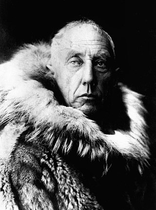
Roald Engelbregt Gravning Amundsen was a Norwegian explorer of polar regions. He was a key figure of the period known as the Heroic Age of Antarctic Exploration.

The Barents Sea is a marginal sea of the Arctic Ocean, located off the northern coasts of Norway and Russia and divided between Norwegian and Russian territorial waters. It was known earlier among Russians as the Northern Sea, Pomorsky Sea or Murman Sea ; the current name of the sea is after the historical Dutch navigator Willem Barentsz.

Fredrik Hjalmar Johansen was a Norwegian polar explorer. He participated on the first and third Fram expeditions. He shipped out with the Fridtjof Nansen expedition in 1893–1896, and accompanied Nansen to notch a new Farthest North record near the North Pole. Johansen also participated in the expedition of Roald Amundsen to the South Pole in 1910–1912.

Fram ("Forward") is a ship that was used in expeditions of the Arctic and Antarctic regions by the Norwegian explorers Fridtjof Nansen, Otto Sverdrup, Oscar Wisting, and Roald Amundsen between 1893 and 1912. It was designed and built by the Scottish-Norwegian shipwright Colin Archer for Fridtjof Nansen's 1893 Arctic expedition in which the plan was to freeze Fram into the Arctic ice sheet and float with it over the North Pole.

An abyssal plain is an underwater plain on the deep ocean floor, usually found at depths between 3,000 and 6,000 metres. Lying generally between the foot of a continental rise and a mid-ocean ridge, abyssal plains cover more than 50% of the Earth's surface. They are among the flattest, smoothest, and least explored regions on Earth. Abyssal plains are key geologic elements of oceanic basins.

Gjøa was the first vessel to transit the Northwest Passage. With a crew of six, Roald Amundsen traversed the passage in a three-year journey, finishing in 1906.

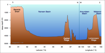
The Eurasian Basin, or Eurasia Basin, is one of the two major basins into which the Arctic Basin of the Arctic Ocean is split by the Lomonosov Ridge. The Eurasia Basin may be seen as an extension of the North Atlantic Basin through Fram Strait. It is further split by the mid-ocean Gakkel Ridge into the Nansen Basin and the Amundsen Basin. The latter basin is the deepest one of the Arctic Ocean and the geographic North Pole is located there.
The Amerasia Basin, or Amerasian Basin, is one of the two major basins from which the Arctic Ocean can be subdivided. The triangular-shaped Amerasia Basin broadly extends from the Canadian Arctic Islands to the East Siberian Sea, and from Alaska to the Lomonosov Ridge. The basin can be further subdivided based on bathymetric features; these include the Canada Basin, the Makarov Basin, the Podvodnikov Basin, the Alpha-Mendeleev Ridge, and the Chukchi Plateau.
The Molloy Deep is a bathymetric feature in the Fram Strait, within the Greenland Sea east of Greenland and about 160 km west of Svalbard. It is the location of the deepest point in the Arctic Ocean. The Molloy Deep, Molloy Hole, Molloy Fracture Zone, and Molloy Ridge were named after Arthur E. Molloy, a U.S. Navy research scientist who worked in the North Atlantic, North Pacific and Arctic Oceans in the 1950s-1970s.

The first ever expedition to reach the Geographic South Pole was led by the Norwegian explorer Roald Amundsen. He and four others arrived at the pole on 14 December 1911, five weeks ahead of a British party led by Robert Falcon Scott as part of the Terra Nova Expedition. Amundsen and his team returned safely to their base, and later heard that Scott and his four companions had died on their return journey.
The Arctic Basin is an oceanic basin in the Arctic Ocean, consisting of two main parts separated by the Lomonosov Ridge, a mid-ocean ridge between north Greenland and the New Siberian Islands. It is bordered by the continental shelves of Eurasia and North America.

The Arctic Ocean is the smallest and shallowest of the world's five major oceans. It spans an area of approximately 14,060,000 km2 (5,430,000 sq mi) and is known as one of the coldest of oceans. The International Hydrographic Organization (IHO) recognizes it as an ocean, although some oceanographers call it the Arctic Mediterranean Sea. It has also been described as an estuary of the Atlantic Ocean. It is also seen as the northernmost part of the all-encompassing World Ocean.

The Fram Strait is the passage between Greenland and Svalbard, located roughly between 77°N and 81°N latitudes and centered on the prime meridian. The Greenland and Norwegian Seas lie south of Fram Strait, while the Nansen Basin of the Arctic Ocean lies to the north. Fram Strait is noted for being the only deep connection between the Arctic Ocean and the World Oceans. The dominant oceanographic features of the region are the West Spitsbergen Current on the east side of the strait and the East Greenland Current on the west.

Nansen's Fram expedition of 1893–1896 was an attempt by the Norwegian explorer Fridtjof Nansen to reach the geographical North Pole by harnessing the natural east–west current of the Arctic Ocean. In the face of much discouragement from other polar explorers, Nansen took his ship Fram to the New Siberian Islands in the eastern Arctic Ocean, froze her into the pack ice, and waited for the drift to carry her towards the pole. Impatient with the slow speed and erratic character of the drift, after 18 months Nansen and a chosen companion, Hjalmar Johansen, left the ship with a team of Samoyed dogs and sledges and made for the pole. They did not reach it, but they achieved a record Farthest North latitude of 86°13.6′N before a long retreat over ice and water to reach safety in Franz Josef Land. Meanwhile, Fram continued to drift westward, finally emerging in the North Atlantic Ocean.
Fiona McLaughlin is a senior Oceanographer, employed by Canada's Department of Fisheries and Oceans. McLaughlin joined government service in 1972. Since 1994 she has concentrated on the ecology of the Arctic Ocean.

The West Spitsbergen Current (WSC) is a warm, salty current that runs poleward just west of Spitsbergen,, in the Arctic Ocean. The WSC branches off the Norwegian Atlantic Current in the Norwegian Sea. The WSC is of importance because it drives warm and salty Atlantic Water into the interior Arctic. The warm and salty WSC flows north through the eastern side of Fram Strait, while the East Greenland Current (EGC) flows south through the western side of Fram Strait. The EGC is characterized by being very cold and low in salinity, but above all else it is a major exporter of Arctic sea ice. Thus, the EGC combined with the warm WSC makes the Fram Strait the northernmost ocean area having ice-free conditions throughout the year in all of the global ocean.

The Amundsen Basin, with depths up to 4.4 km (2.7 mi), is the deepest abyssal plain in the Arctic Ocean, and contains the geographic North Pole. The Amundsen Basin is embraced by the Lomonosov Ridge and the Gakkel Ridge. It is named after the polar researcher Roald Amundsen. Together with the Nansen Basin, the Amundsen Basin is often summarized as Eurasian Basin.