Napasorsuaq | |
---|---|
Kirkespiret | |
Highest point | |
Elevation | 1,590 m (5,220 ft) |
Listing | List of mountains in Greenland |
Coordinates | 60°21′N44°44′W / 60.350°N 44.733°W Coordinates: 60°21′N44°44′W / 60.350°N 44.733°W |
Geography | |
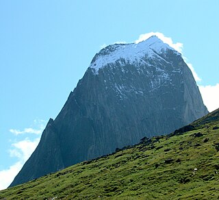
The Napasorsuaq (Danish : Kirkespiret) is a 1,590m–high mountain in southern Greenland, in the Kujalleq municipality. [1]
Danish is a North Germanic language spoken by around six million people, principally in Denmark and in the region of Southern Schleswig in northern Germany, where it has minority language status. Also, minor Danish-speaking communities are found in Norway, Sweden, Spain, the United States, Canada, Brazil, and Argentina. Due to immigration and language shift in urban areas, around 15–20% of the population of Greenland speak Danish as their first language.
A mountain is a large landform that rises above the surrounding land in a limited area, usually in the form of a peak. A mountain is generally steeper than a hill. Mountains are formed through tectonic forces or volcanism. These forces can locally raise the surface of the earth. Mountains erode slowly through the action of rivers, weather conditions, and glaciers. A few mountains are isolated summits, but most occur in huge mountain ranges.
Greenland is an autonomous constituent country of the Kingdom of Denmark between the Arctic and Atlantic oceans, east of the Canadian Arctic Archipelago. Though physiographically a part of the continent of North America, Greenland has been politically and culturally associated with Europe for more than a millennium. The majority of its residents are Inuit, whose ancestors began migrating from the Canadian mainland in the 13th century, gradually settling across the island.
The mountain rises in the mountainous peninsula of the mainland which forms the eastern side of the Southern Sermilik fjord. [2] It is the highest peak of a moderately glaciated mountain chain stretching in a SW/NE direction with summits reaching 1,400 m. The Kirkespirdalen Dal valley, named after the mountain, stretches westwards onto the Saqqa Fjord.
Southern Sermilik is a fjord in southwestern Greenland. Administratively it is part of the Kujalleq municipality.
The Napasorsuaq is a popular mountain among climbers because of its firm granite walls, similar to other peaks in the region such as Ketil and Ulamertorsuaq. [3]
Granite is a common type of felsic intrusive igneous rock that is granular and phaneritic in texture. Granites can be predominantly white, pink, or gray in color, depending on their mineralogy. The word "granite" comes from the Latin granum, a grain, in reference to the coarse-grained structure of such a holocrystalline rock. Strictly speaking, granite is an igneous rock with between 20% and 60% quartz by volume, and at least 35% of the total feldspar consisting of alkali feldspar, although commonly the term "granite" is used to refer to a wider range of coarse-grained igneous rocks containing quartz and feldspar.
The Ketil is a 2,010 m–high mountain in southern Greenland, in the Kujalleq municipality.
The Ulamertorsuaq is a 1,858 m–high mountain in southern Greenland, in the Kujalleq municipality.
![]() |
Mont Forel is a mountain in King Christian IX Land, Sermersooq Municipality, Greenland. It is part of the Schweizerland range, also known as 'Schweizerland Alps'.
The Watkins Range is Greenland's highest mountain range. It is located in King Christian IX Land, Sermersooq municipality.
Tasermiut Fjord is a 70-kilometre-long fjord in southwestern Greenland. Administratively it is part of the Kujalleq municipality. Nanortalik Island is located near the mouth of the fjord.
Napasorsuaq Fjord or Napasorsuup Kangerlua is a fjord of the King Frederick VI Coast in the Sermersooq municipality, southeastern Greenland.
Kangerlussuaq Fjord is a fjord in eastern Greenland. It is part of the Sermersooq municipality.
Midgard Glacier is a glacier on the east coast of the Greenland ice sheet.
Sermilik is a fjord in eastern Greenland. It is part of the Sermersooq municipality.
Azimuthbjerg is the highest mountain in Skjoldungen Island, SE Greenland.
Anorituup Kangerlua, also known as Anoritoq or Anortek Fjord, is a fjord in King Frederick VI Coast, southern Greenland.
The Nalumasortoq or Naluumasortoq is a 2,045 m–high mountain in southern Greenland, in the Kujalleq municipality.
Sam Ford Fiord is an isolated, elongated Arctic fjord on Baffin Island's northeastern coast in the Qikiqtaaluk Region of Nunavut, Canada. The Inuit settlement of Pond Inlet is 320 km (200 mi) to the northwest and Clyde River is 80 km (50 mi) to the east.
Tiningnertok is a mountain in King Frederick VI Coast, Kujalleq municipality, southern Greenland.
Ikersuaq, old spelling Ikerssuak, is a fjord in southwestern Greenland. Administratively it is part of the Kujalleq municipality.
Mount Paatusoq, also known as 'Mount Patuersoq', is the highest mountain in the Kujalleq municipality, SE Greenland.
Schweizerland, also known as Schweizerland Alps, is a mountain range in King Christian IX Land, eastern Greenland. Administratively this range is part of the Sermersooq Municipality. Its highest point is one of the highest peaks in Greenland.
![]() | This Greenland location article is a stub. You can help Wikipedia by expanding it. |