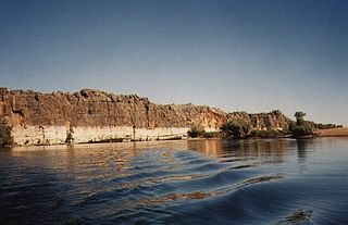
Danggu (Geikie) Gorge National Park is a national park in the Kimberley region of Western Australia, 1,837 kilometres (1,141 mi) northeast of Perth and approximately 420 km (261 mi) east of Broome by road. The gorge was originally named in honour of Sir Archibald Geikie, the Director General of Geological Survey for Great Britain and Ireland when it was given its European name in 1883. Sir Archibald never visited the gorge and the National Park is progressively being officially changed to the Bunuba traditional owners name of Danggu. It is part of the Balili Conservation Park.

Tunnel Creek National Park is a national park in the Kimberley region of Western Australia, 1,845 kilometres (1,146 mi) northeast of Perth and 390 km (240 mi) east of Broome. The natural cave through which Tunnel Creek flows is a major attraction of the park.

Windjana Gorge National Park is a national park in the Kimberley region of Western Australia, 1855 km northeast of Perth and 355 km east of Broome. It is open during the dry season only, usually April to November.

The Kimberley is the northernmost of the nine regions of Western Australia. It is bordered on the west by the Indian Ocean, on the north by the Timor Sea, on the south by the Great Sandy and Tanami deserts in the region of the Pilbara, and on the east by the Northern Territory.
The Canning Basin is a geological basin located in Western Australia.

The Gibb River Road is a road in the Kimberley region of Western Australia.

Fitzroy Crossing is a small town in the Kimberley region of Western Australia, 400 kilometres (250 mi) east of Broome and 300 kilometres (190 mi) west of Halls Creek. It is approximately 2,524 kilometres (1,568 mi) from the state capital of Perth. It is 114 metres (374 ft) above sea level and is situated on a low rise surrounded by the vast floodplains of the Fitzroy River and its tributary Margaret River.
Jandamarra or Tjandamurra, known to European settlers as Pigeon, was an Aboriginal Australian man of the Bunuba people who led one of many organised armed insurrections against the European colonisation of Australia. Initially utilised as a tracker for the police, he became a fugitive when he was forced to capture his own people. He led a three-year campaign against police and European settlers, achieving legendary status for his hit and run tactics and his abilities to hide and disappear. Jandamarra was eventually killed by another tracker at Tunnel Creek on 1 April 1897. His body was buried by his family at the Napier Range, where it was placed inside a boab tree. Jandamarra's life has been the subject of two novels, Ion Idriess's Outlaws of the Leopold (1952) and Mudrooroo's Long Live Sandawarra (1972), a non-fiction account based on oral tradition, Jandamurra and the Bunuba Resistance, and a stage play.

The Wunaamin Miliwundi Ranges, formerly known as the King Leopold Ranges between 1879 and 2020, are a range of hills in the western Kimberley region of Western Australia.

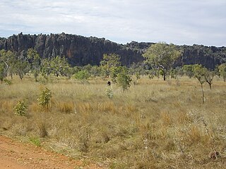
Tunnel Creek is a creek located within the grounds of Tunnel Creek National Park in the Kimberley region of Western Australia. Along with Geikie Gorge and Windjana Gorge, Tunnel Creek is part of an ancient barrier reef that developed during the Devonian Period. Tunnel Creek is located 63 kilometres from the Great Northern Highway, between Derby and Fitzroy Crossing, and was created by waters from a creek that cut a 750-metre tunnel through the reef. The tunnel is 15 metres wide and up to 12 metres high. Tunnel Creek was also the hideout for the Bunuba man Jandamarra, also known as Pigeon, who was killed there by police in 1897.
Windjana Gorge is a gorge in the Kimberley region of Western Australia. It is located within the Windjana Gorge National Park.

Lennard River is a river in the Kimberley region of Western Australia. The river was named on 8 June 1879 by the explorer Alexander Forrest, during an expedition in the Kimberley area, after Amy Eliza Barrett-Lennard (1852-1897), whom he was to marry on 15 January 1880.

Geikie Gorge is a feature of the Napier Range and is located within the grounds of Danggu Gorge National Park, 20 kilometres (12 mi) from Fitzroy Crossing, 1,831 km (1,138 mi) northeast of Perth and 420 km (260 mi) east of Broome in the Kimberley region of Western Australia. Believed to be one of the best-known and most easily accessed, the gorge is named in honour of Sir Archibald Geikie, the Director General of Geological Survey for Great Britain and Ireland when it was given its European name in 1883.
The Barker River is a river in the Kimberley region of Western Australia.
The Richenda River is a river in the Kimberley region of Western Australia.

Bunuba is an Australian Aboriginal language spoken by some 41 older Bunuba adults, most of whom live in Junjuwa, an Aboriginal community in Fitzroy Crossing in Western Australia. Bunuba is not related to the Pama-Nyungan language family that spans the majority of Australia; however, it is a relative of Guniyandi. Both are subgroups of the Bunuban language family. Bunuba consists of two dialects, 'light' and 'heavy' Bunuba.
Tourist Drives in Western Australia are routes through areas of scenic or historic significance, designated by route markers with white numbers on a brown shield. Tourist Drives were introduced into Western Australia while Eric Charlton was the state government Minister for Transport in the 1990s. The 28 numbered routes collectively traverse more than 2,000 kilometres (1,200 mi) across the state. In addition to the Tourist Drives, there are unnumbered routes such as the Golden Pipeline Heritage Trail, and local governments may designate and maintain local scenic drives, generally unnamed and unnumbered.
The Bunuba are a group of Indigenous Australians and are one of the traditional owners of the southern West Kimberley, in Western Australia. Many now live in and around the town of Fitzroy Crossing.
The Balili Conservation Park or Devonian Reef Conservation Park is an Australian protected area and is located in the Kimberley region of Western Australia, about 50km North-West of Fitzroy Crossing. It includes Geikie Gorge National Park, Tunnel Creek National Park and Windjana Gorge National Park.
Napier Downs Station, commonly referred to as Napier Downs, is a pastoral lease that operates as a cattle station in the Kimberley region in Western Australia.

