
Thane is a metropolitan city located on the northwestern side of the state of Maharashtra in India and on the northeastern side of Mumbai. It is an immediate neighbour of Mumbai city proper, and a part of the Mumbai Metropolitan Region. It is situated in the north-eastern portion of the Salsette Island.

Porbandar is a city and the headquarters of Porbandar district in the Indian state of Gujarat. It is the birthplace of Mahatma Gandhi and Sudama. It was the former capital of the Porbandar princely state. Porbandar and Chhaya are the twin cities of each other and both cities are jointly governed by Porbandar–Chhaya Municipal Corporation.

The Victorian government's Wimmera Southern Mallee subregion is part of the Grampians region in western Victoria. It includes most of what is considered the Wimmera, and part of the southern Mallee region. The subregion is based on the social catchment of Horsham, its main settlement.
Palghar is a prominent town in the Konkan division of Maharashtra state, India, and a municipal council. It is Strategically located within the Mumbai Metropolitan Region, and since 2014, it has been the administrative capital of the Palghar district. Palghar plays a crucial role in Western Line of the Mumbai Suburban Railway in the busy Mumbai-Ahmedabad rail corridor. The town is located approximately 87 kilometers north of Mumbai, about 35 kilometers north of Virar, and about 24 kilometers west of the Mumbai-Ahmedabad National Highway at Manor and Mumbai is approximately 50+ km from Palghar.
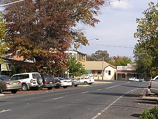
Tumbarumba is a town in New South Wales, Australia, about 480 kilometres (300 mi) southwest of the state capital, Sydney. Tumbarumba is located on the periphery of the Riverina and South West Slopes regions at the western edge of the Snowy Mountains. The 2016 census showed the population of the town and surrounding area to be 1,862 people. Locals refer to the town as 'Tumba'.

Vasai is a historical place and city located in Palghar district; which was partitioned out of the Thana district in 2014. It also forms a part of Vasai-Virar twin cities in the Konkan division, Maharashtra, India, and comes under the Police Jurisdiction of Mira-Bhayander, Vasai-Virar Police Commissionerate.
Nallasopara or Nala Sopara formerly known as Sopara or Supara, is a town within the Mumbai Metropolitan Region. The town lies in the Palghar district of Maharashtra, India, and is governed by Vasai-Virar Municipal Corporation (VVMC). Nallasopara railway station is part of the Western Railway Zone and comes under the Police Jurisdiction of Mira-Bhayander, Vasai-Virar Police Commissionerate.
Karratha is a city in the Pilbara region of Western Australia, adjoining the port of Dampier. It is located in the traditional lands and waters of the Ngarluma people, for whom it has been Ngurra (home/Country) for tens of thousands of years. It was established in 1968 to accommodate the processing and exportation workforce of the Hamersley Iron mining company and, in the 1980s, the petroleum and liquefied natural gas operations of the Woodside-operated North West Shelf Venture located on Murujuga. As of the 2021 census, Karratha had an urban population of 17,013. The city's name comes from the cattle station of the same name, which derives from a word in a local Aboriginal language meaning "good country" or "soft earth". More recently, Ngarluma people have indicated the name may actually relate to an early interpretation of "Gardarra", stemming from the sacred site for the whale, located in the Karratha area, called "Gardarrabuga". The city is the seat of government of the City of Karratha, a local government area covering the surrounding region.

Paraburdoo is a mining town in the Pilbara region of Western Australia. The region is served by Paraburdoo Airport, which is situated 9 kilometres (5.6 mi) from the town.

Thiruvalla, also spelled Tiruvalla, is a municipality in Pathanamthitta district, Kerala, India. It is also the headquarters of the Thiruvalla Taluk & Thiruvalla Revenue Division The town is spread over an area of 27.15 km2 (10.48 sq mi) and has a population of 52,883, down from 56,837 in 2001. It lies on the northern banks of the Manimala River, in a land-locked region surrounded by irrigating canals and rivers. It is the largest town in the district, and is a major financial, educational, healthcare, cultural, and commercial centre in central Travancore.It is also Called The Healthcare City Of Kerala.Thiruvalla Taluk has a land area Of 154 Sq.Km.

Haldia is an industrial port city in Purba Medinipur district in the Indian state of West Bengal. It has a major river port and industrial belt located approximately 124 km (77 mi) southwest of Kolkata near the mouth of the Hooghly River, one of the distributaries of the Ganges. The Haldia Township is bordered by the Haldi River, an offshoot of the Ganges River. Haldia is a centre for petrochemical businesses, and is a major trade port for Kolkata.

Quercus coccifera, the kermes oak or holly oak, is an oak shrub or tree in section Ilex of the genus. It has many synonyms, including Quercus calliprinos. It is native to the Mediterranean region and Northern African Maghreb, south to north from Morocco to France and west to east from Portugal to Cyprus and Turkey, crossing Spain, Italy, Libya, the Balkans, and Greece, including Crete. The Kermes oak was historically important as the food plant of Kermes scale insects, from which a red dye called crimson was obtained. The etymology of the specific name coccifera is related to the production of red cochineal (crimson) dye and derived from Latin coccum which was from Greek κόκκος, the kermes insect. The Latin -fera means 'bearer'.

Dahanu is a coastal town and a municipal council in Palghar district of Maharashtra state in Konkan division. It is located 110 km from Mumbai city and hosts Adani Power’s thermal power station. It is the site of the approved Vadhawan Deep Water Port.
Bhayandar also spells as Bhaindar or Bhayander is a suburb located in the western suburbs of Mumbai and the northern most suburb of the island on the western side, near the Vasai Creek. It has a large Marathi, Aagri, Koli and other mixed populations as well. It falls under the North Central ward of the Municipal Corporation and comes under Police Jurisdiction of Mira-Bhayander, Vasai-Virar Police Commissionerate
Nandarkha is a village situated in the Navsari district of the Indian state of Gujarat. It is positioned in the southwestern region of the Navsari district, lying between the towns of Bilimora and Chikhli.
The Marathi—Konkani languages are the mainland Southern Indo-Aryan languages, spoken in Maharashtra and the Konkan region of India. The other branch of Southern Indo-Aryan languages is called Insular Indic languages, which are spoken in Insular South Asia.

Vasai-Virar is an agglomeration of four previously governed municipal councils: Vasai (Bassein), Virar, Nallasopara and Navghar-Manikpur, as well as a few towns to the east and west of the urban area. It lies in the Konkan division of Maharashtra, India.The twin city of Vasai-Virar is a part of the Mumbai Metropolitan Region (MMR) and Mira-Bhayander, Vasai-Virar Police Commissionerate.
Tandlianwala is a city and Tehsil in Punjab, Pakistan. It is located 40 km from the city of Faisalabad and 44 km from city of Okara. It is a sub-division of Faisalabad District and has a Tehsil Municipal Administration (TMA).
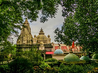
Vasai-Virar City Municipal Corporation (VVCMC) is the civic body that governs areas and villages in Vasai-Virar taluka in Maharashtra, India comprising the most populated part of Palghar district. According to the 2011 census, it is the fifth largest city in Maharashtra with a population of more than 1.3 million. The city is located 50 km north of Mumbai, on the north bank of Vasai Creek, part of the estuary of the Ulhas River. It was formed on 3 July 2010 by combining four municipal councils and 53 gram panchayats.
Jhow Island is a continental island located at the mouth of Vasai Creek of the Vaitarna River in the Arabian Sea, near the Palghar district in Maharashtra, India. It has villages such as Chikhaldongri and Naringi.

