
The Dagaaba people are an ethnic group located north of the convergence of Ghana, Burkina Faso and Côte d'Ivoire. They speak the Dagaare language, a Gur language made up of the related Northern Dagaare dialects, Southern Dagaare dialects and a number of sub dialects. In northern dialects, both the language and the people are referred to as Dagara. They are related to the Birifor people and the Dagaare Diola. The language is collectively known as Dagaare, and historically some non-natives have taken this as the name of the people. One historian, describing the former usage of "Dagarti" to refer to this community by colonials, writes: "The name 'Dagarti' appears to have been coined by the first Europeans to visit the region, from the vernacular root dagaa. Correctly 'Dagari' is the name of the language, 'Dagaaba' or 'Dagara' that of the people, and 'Dagaw' or 'Dagawie' that of the land."

The Songhai people are an ethnolinguistic group in West Africa who speak the various Songhai languages. Their history and lingua franca is linked to the Songhai Empire which dominated the western Sahel in the 15th and 16th century. Predominantly adherents of Islam, the Songhai are primarily located in Niger and Mali. Historically, the term "Songhai" did not denote an ethnic or linguistic identity but referred to the ruling caste of the Songhay Empire known as the Songhaiborai. However, the correct term used to refer to this group of people collectively by the natives is "Ayneha". Although some speakers in Mali have also adopted the name Songhay as an ethnic designation, other Songhay-speaking groups identify themselves by other ethnic terms such as Zarma or Isawaghen. The dialect of Koyraboro Senni spoken in Gao is unintelligible to speakers of the Zarma dialect of Niger, according to at least one report. The Songhay languages are commonly taken to be Nilo-Saharan but this classification remains controversial: Dimmendaal (2008) believes that for now it is best considered an independent language family.

Sekondi-Takoradi is a city in Ghana comprising the twin cities of Sekondi and Takoradi. It is the capital of Sekondi-Takoradi Metropolitan District and the Western Region of Ghana. Sekondi-Takoradi is the region's largest city as well as an industrial and commercial center with a population of 104,847 people, according to the 2021 census.

Elmina, also known as Edina by the local Fante, is a town and the capital of the Komenda/Edina/Eguafo/Abirem District on the south coast of Ghana in the Central Region, situated on a bay on the Atlantic Ocean, 12 kilometres west of Cape Coast. Elmina was the first European settlement in West Africa and it has a population of 33,576 people.
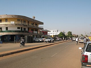
Wa is a town and the capital of the Wa Municipal District and the Upper West Region of Ghana. It has a population of 200,672 people according to the 2021 census.
Lawra is a small town and is the capital of Lawra district, a district in the Upper West Region of Ghana.

The Upper West Region of Ghana is located in the north-western corner of Ghana and is bordered by Upper East Region to the east, Northern Region to the south, and Burkina Faso to the west and north. The Upper West regional capital and largest settlement is Wa. The Upper West was created by the then Head of State, Jerry Rawlings in 1983 under the Provisional National Defence Council (PNDC) military regime. The area was carved out of the former Upper Region, which is now the Upper East Region. For about thirty-five years, it remained the youngest region of Ghana until 2018 when six more regions were created by the Nana Addo Dankwa Akufo-Addo government; hence increasing the total number of administrative regions in the country to sixteen.

The Northern Region is one of the sixteen regions of Ghana. It is situated in the northern part of the country and ranks as the second largest of the sixteen regions. Before its division, it covered an area of 25,000 square kilometres, representing 10 percent of Ghana's area. In December 2018, the Savannah Region and North East Region were created from it. The Northern Region is divided into 16 districts. The region's capital is Tamale, Ghana's third largest city.
Goaso is a town and the capital of the Asunafo North Municipal District and the Ahafo Region of Ghana. It has population of 21,146 according to the 2010 census. The town is run by a traditional council, with Nana Akwasi Bosompra I having the title of Omanhene.

Bolgatanga Municipal District is one of the fifteen districts in Upper East Region, Ghana. Originally created as an ordinary district assembly in 1988 when it was known as Bolgatanga District; which was established by Legislative Instrument (L.I.) 1438, until the southeast part of the district was split off by a decree of president John Agyekum Kufuor in August 2004 to create Talensi-Nabdam District; thus the remaining part was elevated to municipal district assembly status on the same year to become Bolgatanga Municipal District, which was established by Legislative Instrument (L.I.) 1797. However, on 15 March 2018, the eastern part of the district was later split off to create Bolgatanga East District, which was established by Legislative Instrument (L.I.) 2321; thus the remaining part has been retained as Bolgatanga Municipal District. The municipality is located in the central part of Upper East Region and has Bolgatanga as its capital town, which also serves as the capital of the Upper East Region.
The Wala or Waala live in Upper West Region of Ghana. They are a predominantly Muslim people who are the founders of the city of Wa and the Kingdom of Wala. They speak the Wali language, which belongs to the Gur group. There are 84,800 speakers of the language as of 2013. Their neighbors are the Birifor, Dagaaba, and Vagla peoples.

Builsa North is one of the constituencies represented in the Parliament of Ghana. It elects one Member of Parliament (MP) by the first past the post system of election. Builsa North is located in the Builsa district of the Upper East Region of Ghana.

The Kassena people are an ethnic group located along the northern Ghana and Burkina Faso border. They speak the Kasem language. Their king lives in the town of Tiébélé. The Kasenna are closely related to the people of Nankanni and were brought together to form the Kassena-Nankana administrative district in 1936. As of 2008 the (Kassena-Nankana) area comprises two districts: Kassena Nankana West and Kassena Nankana East.

Kasoa, formerly known as Odupongkpehe, is a peri-urban town in the Awutu Senya East Municipal District of the Greater Accra region of Ghana.
Funsi is the district capital of the Wa East District in the Upper West Region of north Ghana.

The Ahmadiyya Muslim Community is the second largest group of Islam in Ghana after Sunni Islam. The early rise of the Community in Ghana can be traced through a sequence of events beginning roughly at the same time as the birth of the Ahmadiyya movement in 1889 in British India. It was during the early period of the Second Caliphate that the first missionary, Abdul Rahim Nayyar was sent to what was then the Gold Coast in 1921 upon invitation from Sunni Muslims in Saltpond. Having established the movement in the country, Nayyar left and was replaced by the first permanent missionary, Al Hajj Fadl-ul-Rahman Hakim in 1922.
The Zabarma Emirate was an Islamic state that existed from the 1860s to 1897 in what is today parts of Ghana and Burkina Faso.
Babatu or Baba Ato, was the Zarma military leader and jihadi warlord over the Zabarma Emirate in the late 19th century. Babatu originated in Indougou (N'Dougou) in what is today the nation of Niger. Babatu became the ruler of the Zabarima emirate in 1878 after the death of the former ruler, Gazari. He was a slaver and fought against Sandema warriors.
Kulmasa is a town in the Sawla-Tuna-Kalba District, Savannah Region, Ghana. In the 1890s, it marked the southern frontier of the Kingdom of Wala.
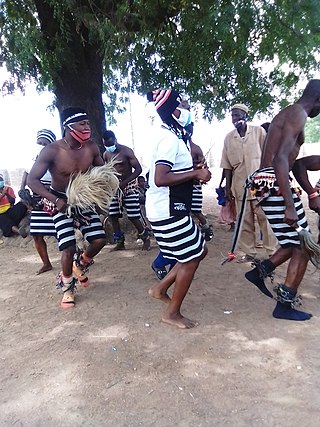
The Battle of Sandema was a battle in Africa that was fought between Babatu and the people of Sandema. The battle is said to have taken place at a place called Akumcham, where the Builsa united and defeated the leader of the Zabarma warriors.