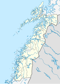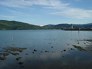
Mo i Rana is a town and the administrative centre of the municipality of Rana in Nordland county, Norway. It is located in the Helgeland region of Nordland, just south of the Arctic Circle. Some of the outlying areas of the town include the suburbs of Båsmoen and Ytteren in the north and Selfors in the east and Åga/Hauknes/Dalsgrenda in the south.
Rana is a municipality in Nordland county, Norway. It is part of the Helgeland traditional region. The administrative centre of the municipality is the town of Mo i Rana, which houses the National Library of Norway. Other population centers in Rana include Alterneset, Båsmoen, Dunderland, Eiteråga, Flostrand, Hauknes, Mæla, Myklebustad, Nevernes, Røssvoll, Selfors, Skonseng, Storforshei, Utskarpen, and Ytteren.

Saltfjellet–Svartisen National Park is a national park in Nordland county in Norway. It is located within the municipalities of Beiarn, Meløy, Rana, Rødøy, Saltdal, and Bodø. European route E06 and the Nordland Line both follow the southern and eastern borders around the park. The park's eastern border is the Norway-Sweden border and a portion of this border is shared with the Vindelfjällen Nature Reserve which lies in Sweden.

Bjørnefossvatnet or Flatisvatnet is a lake in the northwestern part of the municipality of Rana in Nordland county, Norway. The lake is located inside the Saltfjellet–Svartisen National Park, about 30 kilometres (19 mi) north of the town of Mo i Rana. The glacial lake is also the headwaters of the Glomåga river which flows south into the lake Langvatnet.
Blerekvatnet is a lake in the municipality of Rana in Nordland county, Norway. It lies at the northern base of the mountain Junkerfjellet, about 40 kilometres (25 mi) straight east of the town of Mo i Rana.
Bogvatnet (Norwegian) or Tjoamodisjávrre (Lule Sami) is a lake in the municipality of Rana in Nordland county, Norway. The lake is located inside the Saltfjellet–Svartisen National Park, about 40 kilometres (25 mi) north of the town of Mo i Rana. The glacial lake is also the headwaters of the Blakkåga river, a tributary to the main river Ranelva.
Tjårdavatnet or Kjårdavatnet (Norwegian) or Čoađgejávri (Northern Sami) is a lake that is located on the border of Norway and Sweden, about 15 kilometres (9.3 mi) south of the village of Elvegård in Norway. The Norwegian side lies in Narvik Municipality in Nordland county and the Swedish side lies in Gällivare Municipality in Norrbotten County. The lake has an area of about 3.63 square kilometres (1.40 sq mi), with 3.5 square kilometres (1.4 sq mi) being in Norway, the tiny remainder is in Sweden.
Langvatnet (Norwegian) or Tjoaddnejávrre (Lule Sami) is a lake that lies on the border between Norway and Sweden. Almost all of the lake is located in Tysfjord Municipality in Nordland county, Norway with a very small part of the lake in Jokkmokk Municipality in Norrbotten County, Sweden. The 5.46-square-kilometre (2.11 sq mi) lake is located about 20 kilometres (12 mi) southeast of the village of Kjøpsvik in Tysfjord.
Leirvatnet is a lake located on the border between Norway and Sweden. The majority of the 2.57-square-kilometre (0.99 sq mi) lake lies in Sørfold Municipality in Nordland county, Norway, and the remaining 0.06 square kilometres of the lake are located in Jokkmokk Municipality in Norrbotten County, Sweden. The lake lies at one end of the large Blåmannsisen glacier.
Litlumvatnet (Norwegian), Lill-Uman (Swedish), or Jovsjaevrie (Southern Sami) is a lake on the border of Norway and Sweden. The Norwegian side lies in Rana Municipality in Nordland county and the Swedish side lies in Storuman Municipality in Västerbotten County. The lake lies about 40 kilometres (25 mi) southeast of the town of Mo i Rana. The lake is 5.24 square kilometres (2.02 sq mi) and about 1.8 square kilometres (0.69 sq mi) lies inside Norway and the rest lies in Sweden.

Raudvatnet is a lake in the municipality of Rana in Nordland county, Norway. The European route E12 highway passes along the northern and eastern shores of the lake between the town of Mo i Rana and the border with Sweden. A Red cross hut (Rauvasshytta) is located east of the lake Raudvatnet. Water flows into the lake Raudvatnet primarily from the nearby lake Tverrvatnet to the south. From Raudvatnet, the water flows into the river Tverråga, a tributary to the main river Ranelva.

Siiddašjávri (Northern Sami) or Sijdasjávrre (Lule Sami) or Sitasjaure (Swedish) is a lake on the border between Norway and Sweden. Only 0.96 square kilometres (0.37 sq mi) of the 71.91-square-kilometre (27.76 sq mi) lake lies in Norway and the vast majority of the lake lies in Sweden. The Norwegian side is located in Ballangen Municipality in Nordland county. The Swedish side is located in Gällivare Municipality in Norrbotten County. The name of the lake comes from the Sami languages, with the ending -jávri or -jávrre being the word for "lake".
Virvatnet (Norwegian) or Viresjávrre (Lule Sami) is a lake in the municipality of Rana in Nordland county, Norway. It is located in the southeastern corner of the municipality, about 20 kilometres (12 mi) south of the mountain Bolna and less than 2 kilometres (1.2 mi) west of the border with Sweden.
Unna Guovdelisjávri or Vuolip Čoarvejávri is a lake that is located on the border of Norway and Sweden. The Norwegian side lies in Narvik Municipality in Nordland county and the Swedish side lies in Kiruna Municipality in Norrbotten County. The lake lies just east of the lake Gautelisvatnet, about 35 kilometres (22 mi) southeast of the village of Elvegård in Norway. The ending -jávri is the word for "lake" in the Northern Sami language.
Överuman or Uman is a lake on the border between Norway and Sweden. Most of the 52.49-square-kilometre (20.27 sq mi) lake is located in Storuman Municipality in Västerbotten County in Sweden. A small 3.17-square-kilometre (1.22 sq mi) part of the lake, known as Umbukta, is located in Rana Municipality in Nordland County in Norway. The European route E12 highway runs along the eastern side of the lake. The lake lies just southeast of the large lake Storakersvatnet.

Jetnamsklumpen (Norwegian) or Jitnemensnuhkie (Southern Sami) is the highest point of Jetnamfjellet, a mountain on the border of the municipalities of Røyrvik and Hattfjelldal in Norway. The 1,513-metre (4,964 ft) tall mountain is located in the Børgefjell National Park, and it is the highest point in Trøndelag county.

Okstindan is a mountain range which lies in the inner Helgeland district in Nordland county, Norway. It is located within the municipality of Hemnes. The mountain Oksskolten is part of the Okstindan range, and it is the highest mountain in North Norway. Other mountains in the range include Okstinden, Okshornet, Vesttinden, and Bessedørtinden. Between these mountains lies the large glacier Okstindbreen. The Swedish border lies just to the east of the mountains.
Bolna (Norwegian) or Bållná (Lule Sami) is a mountain in the Saltfjellet mountain range in the municipality of Rana in Nordland county, Norway. The mountain peak reaches 1,460 metres (4,790 ft) above sea level, and is located just north of the Arctic Circle inside Saltfjellet–Svartisen National Park. The mountain peak is located less than 2 kilometres (1.2 mi) west of the municipal border with Saltdal and about 15 kilometres (9.3 mi) west of the border with Sweden.
Utskarpen is a village in the municipality of Rana in Nordland county, Norway, about 37 kilometres (23 mi) west of the town of Mo i Rana. The village is located at the end of the Utskarpen fjord, an arm of the main Ranfjorden. On the western side of Utskarpen is the intersection with Norwegian County Road 17 and Norwegian County Road 12. The neighboring villages are Mæla to the north and Myklebustad to the west.

Bolna Station is a train station on the Nordland Line at Bolna in Rana Municipality in Nordland county, Norway. It is located in the upper Dunderland Valley, along the Ranelva river, between the mountains Bolna and Nasafjellet in the eastern part of the municipality, just 6 kilometres (3.7 mi) west of the border with Sweden. The station is located along the European route E06 highway about 28 kilometres (17 mi) northeast of Dunderland Station. The station opened in 1947, but it is now closed to regular traffic.