
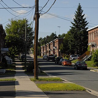
Nashwaak Village
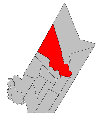
Location of Nashwaak Village in New Brunswick
Nashwaak Village is a settlement located in York County in New Brunswick on the Nashwaak River.
Nashwaak Village is a settlement located in York County in New Brunswick on the Nashwaak River.

The Nashwaak River, located in west-central New Brunswick, Canada, is a tributary of the Saint John River. It is 113 kilometres long. The river rises from Nashwaak Lake and flows south and east through uninhabited land and rapids to the village of Stanley. From Stanley, the Nashwaak flows southeast to Nashwaak Bridge and Taymouth, then south the through several rural communities such as Durham Bridge, the historic town of Nashwaak Village and Penniac before it reaches the town of Marysville. It flows into the Saint John River opposite downtown Fredericton.

Fredericton-Fort Nashwaak was a provincial electoral district for the Legislative Assembly of New Brunswick, Canada. It was first created in the 2006 redrawing of electoral districts and was first used in the general election later that year. Its last MLA was Pam Lynch of the Progressive Conservative Party of New Brunswick.

York North is a provincial electoral district for the Legislative Assembly of New Brunswick, Canada. It was first created in the 1973 out of the old two member district of York by taking those parts of York County outside the city of Fredericton and north of the Saint John River. The districts boundaries were significantly altered in 1994 — losing the villages of Nackawic, Millville and surrounding communities — and its name was changed to Mactaquac as a result. In 2006, its boundaries were restored to nearly its original configuration and though the Electoral Boundaries Commission did not recommend a name change, the legislature later took the decision to revert it to its original name as well.
Marysville is a suburb of Fredericton, New Brunswick, Canada. It is northeast of the city on the Nashwaak River about 5 kilometres (3.1
Route 107 is a highway in New Brunswick, Canada; running from an intersection with Route 8 at Nashwaak Bridge to an intersection with Route 105 at Bristol; a distance of 100.1 kilometres.
Nashwaaksis is a neighbourhood and former village in the city of Fredericton, New Brunswick; it is located on the north bank of the Saint John River and at the mouth of the Nashwaaksis Stream, which should not be confused with the larger Nashwaak River nearby. The word Nashwaaksis is corrupted from the Maliseet word for the area, Nesuwahkik, with the "-sis" appendage meaning "little Nashwaak".

The Fredericton Railway Bridge is a former railway bridge in Fredericton, New Brunswick, Canada now used to carry pedestrians and cyclists.
Penniac is a small rural community in the Canadian province of New Brunswick, located about 10 kilometres northeast of Fredericton. The name Penniac may mean "fork in the river".
Douglas is a civil parish in York County, New Brunswick, Canada.

Saint Marys is a civil parish in York County, New Brunswick, Canada.

Stanley is a civil parish in York County, New Brunswick, Canada.
Durham Bridge is a rural settlement in York County, New Brunswick, Canada. It is located approximately 25 kilometres (16 mi) north of the provincial capital of Fredericton on New Brunswick Route 8, where its eponymous bridge crosses the Nashwaak River. Locally, there is often a distinction made between Upper and Lower Durham, differentiating the settlement north of the bridge from that south of the bridge.
McGivney is a settlement in New Brunswick, located 14.78 km SW of Boiestown, on the Canadian National Railway line, in Stanley Parish, York County.

The Naval battle off St. John took place on July 14, 1696, between France and England toward the end of King William's War in the Bay of Fundy off present-day Saint John, New Brunswick. The English ships were sent from Boston to interrupt the supplies being taken by French officer Pierre Le Moyne d'Iberville from Quebec to the capital of Acadia, Fort Nashwaak on the Saint John River. The French ships of war Envieux and Profond captured the English frigate Newport, while the English frigate Sorlings and a provincial tender escaped.
Carleton is a former community in New Brunswick.
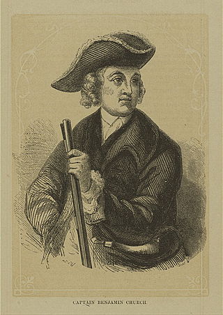
The siege of Fort Nashwaak occurred during King William's War when New England forces from Boston attacked the capital of Acadia, Fort Nashwaak, at present-day Fredericton, New Brunswick. The siege was in retaliation for the French and Indian Siege of Pemaquid (1696) at present day Bristol, Maine. In the English Province of Massachusetts Bay. Colonel John Hathorne and Major Benjamin Church were the leaders of the New England force of 400 men. The siege lasted two days, between October 18–20, 1696, and formed part of a larger expedition by Church against a number of other Acadian communities.
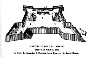
Fort Nashwaak was the capital of Acadia and is now a National Historic Site of Canada in present-day Fredericton, New Brunswick, Canada. It was located strategically up the Saint John River and close to the native village Fort Meductic for military purposes.
Route 620 is a 42.5-kilometre (26.4 mi) long mostly north–south secondary highway in the eastern portion of New Brunswick, Canada.
Route 628 is a 21.9-kilometre (13.6 mi) long mostly north–south secondary highway in the eastern portion of New Brunswick, Canada.
The Becaguimec Stream is a minor tributary of the Saint John River in the Canadian Province of New Brunswick. It rises in the hilly woods along the county line dividing Carleton County, Canada from York County, Canada in the western region of the province. Its watershed is adjacent to the South Branch of the Southwest Miramichi River, the Nashwaak River, the Keswick River and the Nackawic Stream.
Coordinates: 46°05′46″N66°36′42″W / 46.096031°N 66.611695°W
| | This New Brunswick location article is a stub. You can help Wikipedia by expanding it. |