
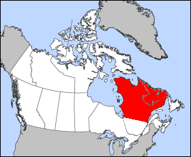
Labrador is a geographic and cultural region within the Canadian province of Newfoundland and Labrador. It is the primarily continental portion of the province and constitutes 71% of the province's area but is home to only 6% of its population. It is separated from the island of Newfoundland by the Strait of Belle Isle. It is the largest and northernmost geographical region in the four Atlantic provinces.
The Labrador Peninsula, or Quebec-Labrador Peninsula, is a large peninsula in eastern Canada. It is bounded by Hudson Bay to the west, the Hudson Strait to the north, the Labrador Sea to the east, and the Gulf of Saint Lawrence to the southeast. The peninsula includes the region of Labrador, which is part of the province of Newfoundland and Labrador, and the regions of Saguenay–Lac-Saint-Jean, Côte-Nord, and Nord-du-Québec, which are in the province of Quebec. It has an area of 1,400,000 km2 (541,000 sq mi).

A drainage basin is an area of land where all flowing surface water converges to a single point, such as a river mouth, or flows into another body of water, such as a lake or ocean. A basin is separated from adjacent basins by a perimeter, the drainage divide, made up of a succession of elevated features, such as ridges and hills. A basin may consist of smaller basins that merge at river confluences, forming a hierarchical pattern.
Churchill River may refer to:

Lake Melville is an estuary of Hamilton Inlet on the Labrador coast of the Canadian province of Newfoundland and Labrador. Comprising 3,069 km2 (1,185 sq mi) and stretching 140 km (87 mi) inland to Happy Valley-Goose Bay, it forms part of the largest estuary in the province, primarily draining the Churchill River and Naskaupi River watersheds. Both Lake Melville and Hamilton Inlet are encircled by mountains, with primary settlements at Happy Valley-Goose Bay, North West River, and Sheshatshiu. It is the 46th largest lake globally.
Hamilton Inlet is a fjord-like inlet of Groswater Bay on the Labrador coast of the Canadian province of Newfoundland and Labrador. Together with Lake Melville, it forms its province's largest estuary, extending over 140 km (87 mi) inland to Happy Valley-Goose Bay and primarily draining the Churchill River and Naskaupi River watersheds. Lake Melville is generally considered a part of Hamilton Inlet and extends west of the deep, narrow passage at the community of Rigolet.

The Churchill River, formerly known by other names, is a river in Newfoundland and Labrador, Canada. It flows east from the Smallwood Reservoir into the Atlantic Ocean via Lake Melville. The river is 856 km (532 mi) long and drains an area of 79,800 km2 (30,800 sq mi), making it the longest river in Atlantic Canada.
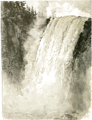
Churchill Falls is a 245 ft (74.7 m) high waterfall on the Churchill River in Labrador, Canada. Formerly counted among the most impressive natural features of Canada, the diversion of the river for the Churchill Falls Generating Station has cut off almost all of the falls' former flow, leaving a small stream winding through its old bed and trickling down the rocks.
Twin Falls is the site of a hydroelectric power station developed by the British Newfoundland Development Corporation (Brinco) to deliver power to mining operations in Labrador City and Wabush.
The Smallwood Reservoir is the reservoir created for the Churchill Falls Generating Station in the western part of Labrador, Canada. Unlike other reservoirs, water is contained not by a single large dam, but by a series of 88 dikes that total 64 km (40 mi) in length in the drainage area of the Churchill River. It is named in honour of Joey Smallwood, the first premier of Newfoundland.
Thomas William Kierans, FCSCE, P. Eng. was an engineer. He was the originator and principal proponent of the Great Recycling and Northern Development Canal or GRAND Canal.

North West River is a small town located in central Labrador. Established in 1743 as a trading post by French Fur Trader Louis Fornel, the community later went on to become a hub for the Hudson's Bay Company and home to a hospital and school serving the needs of coastal Labrador. North West River is the oldest modern settlement in Labrador.

Gaspereau Lake is a lake in Kings County, Nova Scotia, Canada, about 10 km south of the town of Kentville, Nova Scotia on the South Mountain. It is the largest lake in Kings County, and the fifth largest lake in Nova Scotia. The lake is shallow with dozens of forested islands and hundreds of rocky islets (skerries).

Interbasin transfer or transbasin diversion are terms used to describe man-made conveyance schemes which move water from one river basin where it is available, to another basin where water is less available or could be utilized better for human development. The purpose of such water resource engineering schemes can be to alleviate water shortages in the receiving basin, to generate electricity, or both. Rarely, as in the case of the Glory River which diverted water from the Tigris to Euphrates River in modern Iraq, interbasin transfers have been undertaken for political purposes. While ancient water supply examples exist, the first modern developments were undertaken in the 19th century in Australia, India and the United States, feeding large cities such as Denver and Los Angeles. Since the 20th century many more similar projects have followed in other countries, including Israel and China, and contributions to the Green Revolution in India and hydropower development in Canada.

The Churchill Falls Generating Station is a hydroelectric underground power station in Labrador. At 5,428 MW, it is the sixteenth largest in the world, and the second-largest in Canada, after the Robert-Bourassa generating station in northwestern Quebec.

Watersheds of North America are large drainage basins which drain to separate oceans, seas, gulfs, or endorheic basins. There are six generally recognized hydrological continental divides which divide the continent into seven principal drainage basins spanning three oceans and one endorheic basin. The basins are the Atlantic Seaboard basin, the Gulf of Mexico basin, the Great Lakes-St. Lawrence basin, the Pacific basin, the Arctic basin, the Hudson Bay basin, and the Great Basin. Together, the principal basins span the continent with the exception of numerous smaller endorheic basins.

Mina Benson Hubbard was a Canadian explorer and was the first white woman to travel and explore the back-country of Labrador. The Nascaupee and George River system were first accurately mapped by her in 1905. She was the wife of Leonidas Hubbard who was famous for his ill-fated expedition to Labrador in 1903.
The Saint Lawrence River Divide is a continental divide in central and eastern North America that separates the Great Lakes-St. Lawrence River Basin from the southerly Atlantic Ocean watersheds. Water, including rainfall and snowfall, lakes, rivers and streams, north and west of the divide, drains into the Gulf of St. Lawrence or the Labrador Sea; water south and east of the divide drains into the Atlantic Ocean or Gulf of Mexico. The divide is one of six continental divides in North America that demarcate several watersheds that flow to different gulfs, seas or oceans.

Rivers and creeks in Lake County, California are listed below by river basin and alphabetically. Unless otherwise stated, the information is taken from the Geographic Names Information System maintained by the United States Geological Survey. Coordinates, elevations and lengths from this source are approximate.

