National Mills

Last updated
National Mills
788 National Mills, Manitoba.svg
Community boundaries
Canada Manitoba location map 2.svg
Red pog.svg
National Mills
Location in Manitoba
Coordinates: 52°49′26″N101°35′02″W / 52.824°N 101.584°W / 52.824; -101.584 Coordinates: 52°49′26″N101°35′02″W / 52.824°N 101.584°W / 52.824; -101.584
Country Canada
Province Manitoba
Region Northern Manitoba

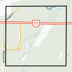
National Mills is a community in the Canadian province of Manitoba. It is part of a group of five communities in the region, all built to serve logging operations in the Porcupine Provincial Forest. The others are Powell, Baden, Red Deer Lake, and the largest, Barrows, where the nearest school and fire service are located. The community contains four housing units. [1]

Demographics

In the 2021 Census of Population conducted by Statistics Canada, National Mills had a population of 0 living in 0 of its 0 total private dwellings, a change of

Related Research Articles

Grandview is an unincorporated urban community in the Grandview Municipality within the Canadian province of Manitoba that held town status prior to January 1, 2015. It is located 45 kilometres west of the City of Dauphin along the Valley River.

<span class="mw-page-title-main">Lockport, Manitoba</span> Place in Manitoba, Canada

Lockport is a small unincorporated community in Manitoba, Canada. It is located 28 kilometres (17 mi) north of the city of Winnipeg along the Red River. The community is split between the Rural Municipalities of St. Andrews and St. Clements.

<span class="mw-page-title-main">Benito, Manitoba</span> Unincorporated urban community in Manitoba, Canada

Benito is an unincorporated urban community in the Municipality of Swan Valley West, Manitoba, Canada.

Erickson is an unincorporated urban community in the Municipality of Clanwilliam – Erickson within the Canadian province of Manitoba that held town status prior to 1 January 2015. It is located on Highway 10 on 32-17-18W in south central Manitoba. The main industry of Erickson is agriculture.

Mystery Lake is a local government district (LGD) in northern Manitoba. It surrounds the city of Thompson, although most of its territory lies to the southwest and south of the city. It is named after Mystery Lake, a lake located in the northeast section of the LGD, northeast of Thompson.

Powerview-Pine Falls is a town in the Canadian province of Manitoba, with a population of 1,314 at the 2011 census, up 1.54% from 1,294 at the 2006 census and down 7.57% from 1,400 during the 2001 census.

<span class="mw-page-title-main">Somerset, Manitoba</span> Place in Manitoba, Canada

Somerset is an unincorporated community recognized as a local urban district in the Municipality of Lorne within the Canadian province of Manitoba that held village status prior to January 1, 2015.

Storthoaks is a village in the Canadian province of Saskatchewan within the Rural Municipality of Storthoaks No. 31 and Census Division No. 1. The village is located approximately 129 km east of the City of Estevan on Highway 361 and 16 km west of the Saskatchewan-Manitoba border.

Stanley is a rural municipality (RM) in the province of Manitoba in Western Canada. It is located in the southern part of the province, along its border with the state of North Dakota in the United States. Since 1876, the area made up part of the Mennonite West Reserve. The municipality has a population of 8,969 as of the 2016 Canada Census. The cities of Winkler and Morden lie geographically within the municipality but are separate urban municipalities.

Whitehead is a rural municipality in the province of Manitoba in Western Canada. It is west of Brandon, Manitoba and the principle communities within its boundaries Kemnay and Alexander.

Rural Municipality of Mountain Rural municipality in Manitoba, Canada

The Rural Municipality of Mountain is a rural municipality in the Parkland Region of Manitoba, western Canada.

Rural Municipality of Elton Rural municipality in Manitoba, Canada

Elton is a rural municipality in the Canadian province of Manitoba, located to the north of the city of Brandon. The community was incorporated in 1883, and its first officials took office the following year.

Bellis, Alberta Hamlet in Alberta, Canada

Bellis is a hamlet in central Alberta, Canada within Smoky Lake County. Previously an incorporated municipality, Bellis dissolved from village status on January 1, 1946 to become part of the Municipal District of Vilna No. 575.

Radway is a hamlet in central Alberta, Canada within Thorhild County. It is located 0.75 kilometres (0.47 mi) southeast of Highway 28, approximately 42 kilometres (26 mi) northeast of Fort Saskatchewan and 70 kilometres (43 mi) northeast of Edmonton.

Speers, Saskatchewan Village in Saskatchewan, Canada

Speers is a village in the Canadian province of Saskatchewan within the Rural Municipality of Douglas No. 436 and Census Division No. 16. The village is located approximately 50 minutes southeast of the City of North Battleford on Highway 40.

Red Deer Lake is a community in the Canadian province of Manitoba. A designated place in Canadian census data, the community had a population of 25 in the Canada 2006 Census.

<span class="mw-page-title-main">Baden, Manitoba</span> Place in Manitoba, Canada

Baden is a northern community in the Canadian province of Manitoba. It is part of a group of five communities in the region, all built to serve logging operations in the Porcupine Provincial Forest. The others are National Mills, Powell, Red Deer Lake, and the largest, Barrows, where the nearest school and fire service are located. The community contains 15 housing units.

Powell is a community in the Canadian province of Manitoba. It is part of a group of five communities in the region, all built to serve logging operations in the Porcupine Provincial Forest. The others are National Mills, Baden, Red Deer Lake, and the largest, Barrows, where the nearest school and fire service are located. The community contains eight housing units.

Miniota, Manitoba is an unincorporated community recognized as a local urban district in Prairie View Municipality, Manitoba, Canada. It is located northwest of Virden near the intersection of PTH 83 and PTH 24. The post office opened in 1885 on 36-13-27W. It was originally named Parkisimo and changed to its present name in 1900. It had two railways in its history: the Canadian Pacific Railway and the Grand Trunk Railway. Both had rail points about one mile apart and there was a Miniota Station on the latter.

Laurier is an unincorporated urban community in the Rural Municipality of Ste. Rose, Manitoba, Canada. It is located on Highway 480, 3.2 km (2.0 mi) west of Highway 5, between the community of McCreary to the south and the community of Ste. Rose du Lac to the north.

References

  1. "National Mills" (PDF). Government of Manitoba. May 2016. Retrieved September 29, 2020.
  2. "Population and dwelling counts: Canada and designated places". Statistics Canada. February 9, 2022. Retrieved Sep 3, 2022.