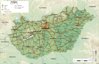
Hungary is a landlocked country in southeastern Central Europe, bordering the Balkans. Situated in the Pannonian Basin, it has a land area of 93,030 square km, measuring about 250 km from north to south and 524 km from east to west. It has 2,106 km of boundaries, shared with Slovakia to the north, Ukraine to the northeast, Romania to the east and southeast, Serbia to the south, Croatia to the south and southwest, Slovenia to the west and southwest, and Austria to the west.

Austria is a predominantly mountainous country in Central Europe, approximately between Germany, Italy and Hungary. It has a total area of 83,871 square kilometres (32,383 sq mi).

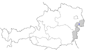
Burgenland is the easternmost and least populous state of Austria. It consists of two statutory cities and seven rural districts, with a total of 171 municipalities. It is 166 km (103 mi) long from north to south but much narrower from west to east. The region is part of the Centrope Project. The name of Burgenland was invented/coined in 1922, after its territories became part of Austria. The population of Burgenland as of 1 January 2024 is 301,951. Burgenland's capital is Eisenstadt.

The Bavarian Forest National Park is a national park in the Eastern Bavarian Forest immediately on Germany's border with the Czech Republic. It was founded on 7 October 1970 as the first national park in Germany. Since its expansion on 1 August 1997 it has covered an area of 24,250 hectares. Together with the neighbouring Czech Bohemian Forest the Bavarian Forest forms the largest contiguous area of forest in Central Europe.

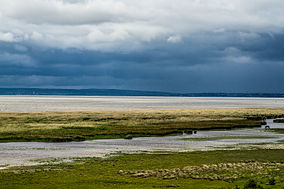
Lake Neusiedl, or Fertő, is the largest endorheic lake in Central Europe, straddling the Austrian–Hungarian border. The lake covers 315 km2 (122 sq mi), of which 240 km2 (93 sq mi) is on the Austrian side and 75 km2 (29 sq mi) on the Hungarian side. The lake's drainage basin has an area of about 1,120 km2 (430 sq mi). From north to south, the lake is about 36 km (22 mi) long, and it is between 6 km and 12 km wide from east to west. On average, the lake's surface is 115.45 m (378.8 ft) above the Adriatic Sea and the lake is no more than 1.8 m deep.

The Little Hungarian Plain or Little Alföld is a plain of approximately 8,000 km² in northwestern Hungary, south-western Slovakia, and eastern Austria. It is a part of the Pannonian plain which covers most parts of Hungary.

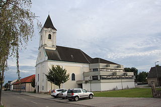
Purbach am Neusiedlersee, which is sometimes written as Purbach am Neusiedler See or Purbach am See, is a town in the Austrian state of Burgenland known for its viticulture. It lies in the Eisenstadt-Umgebung district.

The Danubian Lowland or Danube Lowland is the name of the part of Little Alföld situated in Slovakia, located between the Danube, the Little Carpathians and all other parts of the Western Carpathians.

Colias chrysotheme, the lesser clouded yellow, is a small Palearctic butterfly belonging to the family Pieridae.

Vipera ursinii is a species of venomous snake in the subfamily Viperinae of the family Viperidae. It is a very rare species, which is in danger of extinction. This species is commonly called the meadow viper, Ursini' s viper, or meadow adder. It is found in France, Italy, and Greece as well as much of eastern Europe. Several subspecies are recognized. Beyond the highly threatened European population, poorly known populations exist as far to the east as Kazakhstan and northwestern China.

Austria has six national parks, all of them internationally accepted according to the IUCN standard. The first national park, Hohe Tauern, was established in 1981. They include each of Austria's most important natural landscape types — alluvial forest, Alpine massif, Pannonian steppe and rocky valleys.

The Eurasian Steppe, also called the Great Steppe or The Steppes, is the vast steppe ecoregion of Eurasia in the temperate grasslands, savannas and shrublands biome. It stretches through Hungary, Bulgaria, Romania, Moldova, Ukraine, southern Russia, Kazakhstan, Xinjiang, Mongolia and Manchuria, with one major exclave, the Pannonian steppe, located mostly in Hungary.
Apetlon is a market town in the district of Neusiedl am See in Burgenland in Austria. It is located in a region to the east of Lake Neusiedl which is named the Seewinkel.
Illmitz is a market town in the district of Neusiedl am See in Burgenland in Austria. It is located in a region to the east of the Lake Neusiedl which is named the Seewinkel.

Jois is a small town in the district of Neusiedl am See in Burgenland in Eastern Austria. It is on the northern shore of Lake Neusiedl, which straddles the border with Hungary.
Podersdorf am See is a market town in the district of Neusiedl am See in Burgenland in the east of Austria on the shore of the Neusiedler See. It is home to a windmill and lake.

Fertő-Hanság National Park is a national Park in North-West Hungary in Győr-Moson-Sopron county. It was created in 1991, and officially opened together with the connecting Austrian Neusiedler See-Seewinkel National Park the same year. The park covers 235.88 km2, and consists of two main areas.

The Pannonian Steppe is a variety of grassland ecosystems found in the Pannonian Basin. It is an exclave of the Great Eurasian Steppe, found in modern-day Austria, Bulgaria, Hungary, Romania, Serbia, Slovakia and easternmost parts of Croatia.

Orenburg Nature Reserve is a Russian 'zapovednik' dedicated to the preservation and restoration of four separate types of steppe landscape: Transvolga, Ural Mountains, Southern Urals and Trans-Urals. The reserve does this by spreading out across four sections across 400 km of steppes in Orenburg Oblast below the southern terminus of the Ural Mountains. The city of Orenburg sits in the middle of the four sectors, approximately 1,200 km southeast of Moscow. The reserve also protects historical and archaeological sites of the Sarmation people from the seventh to third century BCE. The reserve was formally established in 1988, and covers a total area of 21,653 ha (83.60 sq mi).

Camptopoeum friesei is a species of bees of the genus Camptopoeum.