
Manawatū-Whanganui is a region in the lower half of the North Island of New Zealand, whose main population centres are the cities of Palmerston North and Whanganui. It is administered by the Manawatū-Whanganui Regional Council, which operates under the name Horizons Regional Council.

National Park is a small town on the North Island Central Plateau in New Zealand. Also known as National Park Village, it is the highest urban township in New Zealand, at 825 metres. Its name derives from its location just outside the boundary of Tongariro National Park, New Zealand's first national park, and its only national park from its creation in 1887 until 1900. The village has great views of Mount Tongariro, Mount Ngauruhoe, and Mount Ruapehu.

Tongariro National Park is the oldest national park in New Zealand, located in the central North Island. It has been acknowledged by UNESCO as a World Heritage Site of mixed cultural and natural values.

Tawa is the northernmost suburb within the Wellington city boundary, located roughly 15 km north of Wellington's CBD between Churton Park and Porirua in the North Island of New Zealand. It takes its name from the broadleaf tree, which was once prolific throughout the area, although its most famous tree is the Bucket Tree, a large macrocarpa with the topiary of an upside-down bucket. Tawa is also known for its large number of churches, representing a wide range of Christian denominations.

Ohakune is a small town in the North Island of New Zealand, situated 215 kilometres north of Wellington and 292 kilometres south of Auckland. It is located at the southern end of the Tongariro National Park, close to the southwestern slopes of the active volcano Mount Ruapehu. Located within the Manawatu-Wanganui region, the town is 70 kilometres northeast of Wanganui and 25 kilometres west of Waiouru.
The North Island Volcanic Plateau is a volcanic plateau covering much of central North Island of New Zealand with volcanoes, lava plateaus, and crater lakes.

Raetihi is a town in the central North Island of New Zealand. It is located at the junction of State Highways 4 and 49, 11 kilometres west of Ohakune. The 2013 New Zealand census recorded its population as 1,002. This constitutes a decrease of 3.2% or 33 people since the 2006 census. 65.3% of residents identified as Māori, 55% European, 2.7% Pacific and 1.2% Asian. The Waimarino district stretches from Mount Ruapehu to the Wanganui River encompassing Raetihi, Pipiriki, Karioi, Horopito, Waiouru, Rangataua and Ohakune. There is evidence of Maori people living here in the fourteenth century. The Ngati Uenuku dwelled at Raetihi and Waimarino. There is little evidence of large permanent settlements but hunting parties were common during warmer months.
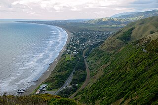
Paekakariki is a town in the Kapiti Coast District in the south-western North Island of New Zealand. It is 22 km (14 mi) north of Porirua and 45 km (28 mi) northeast of Wellington, the nation's capital city. The town's name comes from the Māori language and can mean "parakeet perch".

Kakahi ) is a small King Country settlement about 10 kilometres (6.2 mi) up the Whanganui River from Taumarunui, New Zealand. Founded as a sawmill town, it takes its name from the Māori word for the New Zealand freshwater mussel.

Ruapehu District is a territorial authority in the centre of New Zealand's North Island.
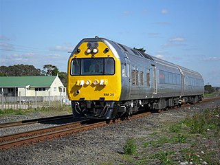
The NZR RM class Silver Fern is a class of rail motor in New Zealand. The three air-conditioned and sound-proofed 723-kW 96-seater diesel-electric twin-set railcars were built by Kawasaki and Toshiba, trading as Nissho Iwai Company of Japan. The New Zealand Railways classed the railcars RM, like all other railcars.

The Newmarket Line is a railway line in Auckland, New Zealand, that runs between Quay Park Junction, near Britomart Transport Centre, and Newmarket Train Station. It is 2.64 km long. It connects the North Island Main Trunk (NIMT), which runs from the east into Britomart via the waterfront, and the North Auckland Line (NAL), which runs between Westfield Junction and Otiria via Newmarket and Whangarei. It has been named the Newmarket Line since 2011. From 1996 to 2011, it was named the Auckland–Newmarket Line, as it ran from Auckland Railway Station until the station closed in 2003. From 1977 to 1996, it was named the Newmarket Branch Railway.
The Raetihi Branch was a branch line railway in the central North Island of New Zealand. It formed part of New Zealand's national rail network and operated from 1917 until 1968.
There have been a number of proposals to build a Taupo Line as a branch railway linking the township of Taupo in the central North Island of New Zealand to New Zealand's rail network. One proposal proceeded as far as the construction stage before being stopped.
Manunui is a small Whanganui River settlement, about 6 kilometres (3.7 mi) east of Taumarunui on State Highway 4, in New Zealand's King Country. It was once known as Waimarino, but John Burnand of the Ellis and Burnand sawmilling firm renamed it Manunui around 1905.
State Highway 49 (SH 49) is a New Zealand state highway, linking SH 4 and SH 1, via the tourist town of Ohakune. It forms the southern part of the ring road surrounding Tongariro National Park and provides access to the southern side of Mount Ruapehu and the Turoa skifield. It roughly follows the North Island Main Trunk railway.

Rangataua is a small village in the North Island of New Zealand. It is located at the southern end of both the Tongariro National Park and Rangataua State Forest, adjacent to the southwestern slopes of the active volcano Mount Ruapehu. Part of the Manawatu-Wanganui region, the town is 5 kilometres east of Ohakune, 75 kilometres northeast of Wanganui, and 20 kilometres west of Waiouru.
The Taneatua Branch is a branch railway line from Hawkens Junction to Taneatua in the Bay of Plenty, New Zealand.
The Murupara Branch is a branch railway line from the East Coast Main Trunk at Hawkens Junction near Edgecumbe via Kawerau to Murupara; built to serve a new pulp and paper mill harvesting the radiata pine trees of the Kaingaroa Forest on the Kaingaroa Plateau in the Bay of Plenty, New Zealand. The line was the last major extension of the NZR network; of 14 km from Hawkens Junction to Kawerau and 57 km from Kawerau to Murupara. The portion from Hawkens Junction to Kawerau is now officially part of the East Coast Main Trunk.

Otorohanga railway station has served the town of Otorohanga, on the North Island Main Trunk in New Zealand since 1887. It was 4.45 km (2.77 mi) south of Kiokio and 9.21 km (5.72 mi) north of Hangatiki, but is now one of only 9 stations on the line served by the Northern Explorer.
