
Highways in Australia are generally high capacity roads managed by state and territory government agencies, though Australia's federal government contributes funding for important links between capital cities and major regional centres. Prior to European settlement, the earliest needs for trade and travel were met by narrow bush tracks, used by tribes of Indigenous Australians. The formal construction of roads began in 1788, after the founding of the colony of New South Wales, and a network of three major roads across the colony emerged by the 1820s. Similar road networks were established in the other colonies of Australia. Road construction programs in the early 19th century were generally underfunded, as they were dependent on government budgets, loans, and tolls; while there was a huge increase in road usage, due to the Australian gold rushes. Local government authorities, often known as Road Boards, were therefore established to be primarily responsible for funding and undertaking road construction and maintenance. The early 1900s saw both the increasingly widespread use of motorised transportation, and the creation of state road authorities in each state, between 1913 and 1926. These authorities managed each state's road network, with the main arterial roads controlled and maintained by the state, and other roads remaining the responsibility of local governments. The federal government became involved in road funding in the 1920s, distributing funding to the states. The depression of the 1930s slowed the funding and development of the major road network until the onset on World War II. Supply roads leading to the north of the country were considered vital, resulting in the construction of Barkly, Stuart, and Eyre Highways.
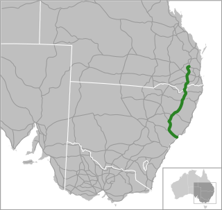
New England Highway is an 883-kilometre (549 mi) long highway in Australia running from Yarraman, north of Toowoomba, Queensland, at its northern end to Hexham at Newcastle, New South Wales, at its southern end. It is part of Australia's National Highway system, and forms part of the inland route between Brisbane and Sydney.

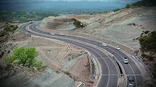
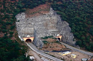
The national highways in India are a network of limited access roads owned by the Ministry of Road Transport and Highways. National highways have flyover access or some controlled-access, where entrance and exit is through the side of the flyover. At each highway intersection, flyovers are provided to bypass the traffic on the city, town, or village. These highways are designed for speeds of 100 km/h. Some national highways have interchanges in between, but do not have total controlled-access throughout the highways. The highways are constructed and managed by the Central Public Works Department (CPWD), the National Highways and Infrastructure Development Corporation Limited (NHIDCL), and the public works departments (PWD) of state governments. Currently, the longest national highway in India is National Highway 44 at 4,112 km. India started four laning of major national highways with the National Highway Development Project (NHDP). As of March 2022 India has approximately 35,000 km of four laned National highways.

Roads in India are an important mode of transport in India. India has a network of over 6,331,791 kilometres (3,934,393 mi) of roads. This is the second-largest road network in the world, after the United States. At of roads per square kilometre of land, the quantitative density of India's road network is equal to that of Hong Kong, and substantially higher than the United States, China, Brazil and Russia. Adjusted for its large population, India has approximately 5.13 kilometres (3.19 mi) of roads per 1,000 people, which is much lower than United States 20.5 kilometres (12.7 mi) but higher than that of China 3.6 kilometres (2.2 mi). India's road network carries over 71% of its freight and about 85% of passenger traffic.

The N87 road is a national secondary road in the north of County Cavan, Ireland.

The Outer Ring Road, officially known as Nehru Outer Ring Road and abbreviated as, O.R.R., is a 158-kilometre (98 mi), eight-lane ring road expressway encircling Hyderabad, capital of the Indian state of Telangana. The expressway is designed for speeds up to 100 kilometres per hour (62 mph), which later increased to 120 kilometres per hour (75 mph). A large part, 124 kilometres (77 mi) of the 158 kilometres (98 mi) was opened by December 2012.
National Highway 44 is a major north–south National Highway in India and is the longest in the country.
Expressways are the highest class of roads in India. In July 2023, the total length of expressways in India was 5,930 km (3,680 mi), with 11,127.69 km (6,914.43 mi) under construction. These are controlled-access highways where entrance and exits are controlled by the use of cloverleaf, three-way, trumpet or grade separated interchanges that are incorporated into the design of the expressway and designed for maximum speed of 120 km/h, whereas National highways are flyover access or tolled, where entrance and exit is through the side of the flyover, at each intersection of highway with road, flyovers are provided to bypass the city/town/village traffic and these highways are designed for speed of 100 km/h. Some roads are not access-controlled expressways but are still named expressways, such as the Bagodara–Tarapur Expressway, Biju Expressway, these are actually state highways that are not declared by the central government as an Expressway, hence not an Expressway or National Highway.

The Ministry of Road Transport and Highways (MoRTH) is a ministry of the Government of India, that is the apex body for formulation and administration of the rules, regulations and laws relating to road transport, transport research and in also to increase the mobility and efficiency of the road transport system in India. Through its officers of Central Engineering Services (Roads) cadre it is responsible for the development of National Highways of the country.

Mad Max: Fury Road is a 2015 Australian post-apocalyptic action film co-written, co-produced, and directed by George Miller. Miller collaborated with Brendan McCarthy and Nico Lathouris on the screenplay. The fourth installment in the Mad Max franchise, it was produced by Village Roadshow Pictures, RatPac-Dune Entertainment and Kennedy Miller Mitchell, and distributed by Roadshow Entertainment in Australia and by Warner Bros. Pictures internationally. The film stars Tom Hardy and Charlize Theron, with Nicholas Hoult, Hugh Keays-Byrne, Rosie Huntington-Whiteley, Riley Keough, Zoë Kravitz, Abbey Lee, and Courtney Eaton in supporting roles. Set in a post-apocalyptic desert wasteland where petrol and water are scarce commodities, Fury Road follows Max Rockatansky (Hardy), who joins forces with Imperator Furiosa (Theron) against warlord Immortan Joe (Keays-Byrne) and his army, leading to a lengthy road battle.
National Highway 21 is a primary national highway in India. This highway connects Jaipur in Rajasthan to Agra and Bareilly in Uttar Pradesh This national highway is 465 km (289 mi) long.
National Highway 127B, commonly called NH 127B is a National Highway in North East India that connects Srirampur in Assam to Nongston in Meghalaya.
National Highway 143A, commonly called NH 143A is a national highway in India. It is a spur road of National Highway 43. NH-143A traverses the state of Jharkhand in India.
National Highway 133A, commonly called NH 133A is a national highway in India. It is a spur road of National Highway 33. NH-133A traverses the states of Jharkhand and West Bengal in India.
National Highway 419, commonly called NH 419 is a national highway in India. It is a spur road of National Highway 19. NH-419 traverses the states of Jharkhand and West Bengal in India.
National Highway 163A, commonly called NH 163A is a national highway in India. It is a spur road of National Highway 63. NH-163A traverses the state of Chhattisgarh in India.
National Highway 149B, commonly called NH 149B is a national highway in India. It is a spur road of National Highway 49. NH-149B traverses the state of Chhattisgarh in India.
National Highway 321, commonly referred to as NH 321 is a national highway in India. It is a spur road of National Highway 21. NH-321 runs in the state of Uttar Pradesh in India.
National Highway 143H, commonly referred to as NH 143H is a national highway in India. It is a secondary route of National Highway 43. NH-143H runs in the states of Odisha and Jharkhand in India.
National Highway 143D, commonly referred to as the NH 143D is a national highway in India. It is a secondary route of National Highway 43. NH-143D runs in the state of Jharkhand in India.
