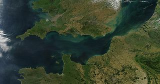
The English Channel, also known as the Channel or British Sea, is an arm of the Atlantic Ocean that separates Southern England from northern France. It links to the southern part of the North Sea by the Strait of Dover at its northeastern end. It is the busiest shipping area in the world.
A nautical mile is a unit of length used in air, marine, and space navigation, and for the definition of territorial waters. Historically, it was defined as the meridian arc length corresponding to one minute of latitude at the equator. Today the international nautical mile is defined as 1,852 metres. The derived unit of speed is the knot, one nautical mile per hour.

The Corporation of Trinity House of Deptford Strond, also known as Trinity House, is the official authority for lighthouses in England, Wales, the Channel Islands and Gibraltar. Trinity House is also responsible for the provision and maintenance of other navigational aids, such as lightvessels, buoys, and maritime radio/satellite communication systems. It is also an official deep sea pilotage authority, providing expert navigators for ships trading in Northern European waters.

A fathom is a unit of length in the imperial and the U.S. customary systems equal to 6 feet (1.8288 m), used especially for measuring the depth of water. The fathom is neither an international standard (SI) unit, nor an internationally accepted non-SI unit. Historically it was the maritime measure of depth in the English-speaking world but, apart from within the US, charts now use metres.

A nautical chart or hydrographic chart is a graphic representation of a sea region or water body and adjacent coasts or banks. Depending on the scale of the chart, it may show depths of water (bathymetry) and heights of land (topography), natural features of the seabed, details of the coastline, navigational hazards, locations of natural and human-made aids to navigation, information on tides and currents, local details of the Earth's magnetic field, and human-made structures such as harbours, buildings, and bridges. Nautical charts are essential tools for marine navigation; many countries require vessels, especially commercial ships, to carry them. Nautical charting may take the form of charts printed on paper or computerized electronic navigational charts. Recent technologies have made available paper charts which are printed "on demand" with cartographic data that has been downloaded to the commercial printing company as recently as the night before printing. With each daily download, critical data such as Local Notices to Mariners are added to the on-demand chart files so that these charts are up to date at the time of printing.

Skelmorlie is a village in North Ayrshire in the southwest of Scotland. Although it is the northernmost settlement in the council area of North Ayrshire, it is contiguous with Wemyss Bay, which is in Inverclyde. The dividing line is the Kelly Burn, which flows into the Firth of Clyde just south of the Rothesay ferry terminal. Despite their proximity, the two villages have historically been divided, Skelmorlie in Ayrshire and Wemyss Bay in Renfrewshire.
Piloting or pilotage is the process of navigating on water or in the air using fixed points of reference on the sea or on land, usually with reference to a nautical chart or aeronautical chart to obtain a fix of the position of the vessel or aircraft with respect to a desired course or location. Horizontal fixes of position from known reference points may be obtained by sight or by radar. Vertical position may be obtained by depth sounder to determine depth of the water body below a vessel or by altimeter to determine an aircraft's altitude, from which its distance above the ground can be deduced. Piloting a vessel is usually practiced close to shore or on inland waterways. Pilotage of an aircraft is practiced under visual meteorological conditions for flight.
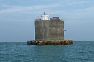
The Nab Tower was a tower planned for anti-submarine protection in the English Channel in World War I. It was sunk over the Nab rocks east of the Isle of Wight to replace a lightship after the war, and is a well-known landmark for sailors as it marks the deep-water eastern entry into the Solent.

The United Kingdom Hydrographic Office (UKHO) is the UK's agency for providing hydrographic and marine geospatial data to mariners and maritime organisations across the world. The UKHO is a trading fund of the Ministry of Defence (MoD) and is located in Taunton, Somerset, with a workforce of approximately 900 staff.

Sailing Directions are written directions that describe the routes to be taken by boats and ships during coastal navigation and port approaches. There are also products known as Sailing Directions, which are books written by various Hydrographic Offices throughout the world. They are known as Pilot Books, because they provide local knowledge of routes and landmarks, which would typically be provided by a local marine pilot. As such, they are used frequently by naval and government vessels, who are exempted from 'Compulsory Pilotage' in many ports.
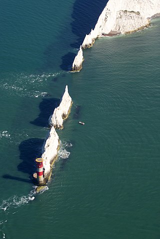
The Needles Lighthouse is an active 19th century lighthouse on the outermost of the chalk rocks at The Needles on the Isle of Wight in the United Kingdom, near sea level. Designed by James Walker, for Trinity House at a cost of £20,000. It was completed in 1859 from granite blocks, stands 33.25 metres (109.1 ft) high and is a circular tower with straight sides. It replaced an earlier light tower on top of a cliff overhanging Scratchell's Bay, which was first lit on 29 September 1786.

Casquets Lighthouse is an active lighthouse located on the rocky Les Casquets, Alderney, Channel Islands.

The North Bull Lighthouse, is an active aid to navigation located at the mouth of the River Liffey, near Dublin, Ireland. It is one of four lighthouses that help guide shipping into the Liffey, and the Port of Dublin, all of which are operated and maintained by the Dublin Port Company.

The Cairns of Coll refers primarily to a region of rocky outcrops in shallow waters extending from the north end of the Island of Coll in the Inner Hebrides of Scotland. The extension is about 1.1 miles from shore, 1.6 if the Cairns of Coll Rocks 0.5 miles further are to be included. The outcrops of the Cairns are too small to be inhabited. The swift and unpredictable tidal currents between them make navigation hazardous to boats. They are rich in abundant and varied marine life, including the marine mammals.

Plover Scar Lighthouse, also known as the Abbey Lighthouse, is an active 19th century lighthouse sited at the entrance of the Lune estuary, near Cockersand Abbey in Lancashire, England. The lighthouse is maintained by the Lancaster Port Commission. It is registered under the international Admiralty number A4876 and has the NGA identifier of 114-5144.

The North Bank or Northbank Lighthouse, is an active aid to navigation located at the mouth of the River Liffey, near Dublin, Ireland. It is one of four lighthouses that help guide shipping into the Liffey, and the Port of Dublin, all of which are operated and maintained by the Dublin Port Company. Built in 1882, it also affectionately called The Tea Caddy due to its architecture, and has also been described as "resembling a giant mailbox on stilts".

Henry Charles Otter was a Royal Navy officer and hydrographic surveyor, noted for his work in charting Scotland in the mid-19th century. He was active in surveying in the Baltic Sea during the war with Russia (1853-6) and in supporting the laying of the first transatlantic telegraph cable in 1858.

George Thomas was a Master in the Royal Navy who was one of the early surveyors of the coasts of Great Britain

Edward Killwick Calver was a Captain in the Royal Navy, and hydrographic surveyor. He is particularly noted for his surveying work in the east of Britain, and as the captain of HMS Porcupine, in oceanographic voyages in 1869 and 1870.
