A waypoint is an intermediate point or place on a route or line of travel, a stopping point or point at which course is changed, the first use of the term tracing to 1880. In modern terms, it most often refers to coordinates which specify one's position on the globe at the end of each "leg" (stage) of an air flight or sea passage, the generation and checking of which are generally done computationally.

A nautical chart is a graphic representation of a sea area and adjacent coastal regions. Depending on the scale of the chart, it may show depths of water and heights of land, natural features of the seabed, details of the coastline, navigational hazards, locations of natural and human-made aids to navigation, information on tides and currents, local details of the Earth's magnetic field, and human-made structures such as harbours, buildings, and bridges. Nautical charts are essential tools for marine navigation; many countries require vessels, especially commercial ships, to carry them. Nautical charting may take the form of charts printed on paper or computerized electronic navigational charts. Recent technologies have made available paper charts which are printed "on demand" with cartographic data that has been downloaded to the commercial printing company as recently as the night before printing. With each daily download, critical data such as Local Notices to Mariners are added to the on-demand chart files so that these charts are up to date at the time of printing.

A navigator is the person on board a ship or aircraft responsible for its navigation. The navigator's primary responsibility is to be aware of ship or aircraft position at all times. Responsibilities include planning the journey, advising the ship's captain or aircraft commander of estimated timing to destinations while en route, and ensuring hazards are avoided. The navigator is in charge of maintaining the aircraft or ship's nautical charts, nautical publications, and navigational equipment, and they generally have responsibility for meteorological equipment and communications. With the advent of satellite navigation, the effort required to accurately determine one's position has decreased by orders of magnitude, so the entire field has experienced a revolutionary transition since the 1990s with traditional navigation tasks, like performing celestial navigation, being used less frequently. Using multiple independent position fix methods without solely relying on electronic systems subject to failure helps the navigator detect errors. Professional mariners are still proficient in traditional piloting and celestial navigation.
Garmin Ltd. is an American, Swiss-domiciled multinational technology company founded in 1989 by Gary Burrell and Min Kao in Lenexa, Kansas, United States, with headquarters in Olathe, Kansas. Since 2010, the company is legally incorporated in Schaffhausen, Switzerland.
DeLorme Publishing Company was a producer of personal satellite tracking, messaging, and navigation technology. In 2016, Garmin acquired the company's products and the DeLorme trademark. The company's main product, inReach, integrates GPS and satellite technologies. inReach provides the ability to send and receive text messages anywhere in the world by using the Iridium satellite constellation. By pairing with a smart phone, navigation is possible with access to free downloadable topographic maps and National Oceanic and Atmospheric Administration (NOAA) charts. On February 11, 2016, the company announced that it had been purchased by Garmin, a multinational producer of GPS products and services.

The Garmin Forerunner series is a selection of sports watches produced by Garmin. Most models use the Global Positioning System (GPS), and are targeted at road runners and triathletes. Forerunner series watches are designed to measure distance, speed, heart rate (optional), time, altitude, and pace.
Navigational instruments are instruments used by nautical navigators and pilots as tools of their trade. The purpose of navigation is to ascertain the present position and to determine the speed, direction, etc. to arrive at the port or point of destination.

The Yeoman Plotter was a plotter used on ships and boats to transfer GPS coordinates or RADAR echo locations onto a paper navigation chart and to read coordinates from the chart. It was manufactured from 1985 to 2014/2015 and was an intermediary step between traditional paper chart navigation and full electronic chart displays. It was easy to understand for people that were accustomed to paper charts and much cheaper than electronic chart displays available at the time. The continuing fall in prices of electronic chart displays, their increase in functionality such as radar overlay and the advent of cheap tablets eventually made the Yeoman plotter uncompetitive.
Jeppesen is an American company offering navigational information, operations planning tools, flight planning products and software. Jeppesen's aeronautical navigation charts are often called "Jepp charts" or simply "Jepps" by pilots, due to the charts' popularity. This popularity extends to electronic charts, which are increasingly favored over paper charts by pilots and mariners as mobile computing devices, electronic flight bags, integrated electronic bridge systems and other display devices become more common and readily available.

A point of interest (POI) is a specific point location that someone may find useful or interesting. An example is a point on the Earth representing the location of the Eiffel Tower, or a point on Mars representing the location of its highest mountain, Olympus Mons. Most consumers use the term when referring to hotels, campsites, fuel stations or any other categories used in modern automotive navigation systems.

Stick charts were made and used by the Marshallese to navigate the Pacific Ocean by canoe off the coast of the Marshall Islands. The charts represented major ocean swell patterns and the ways the islands disrupted those patterns, typically determined by sensing disruptions in ocean swells by islanders during sea navigation.
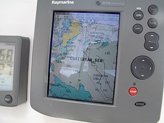
A Chartplotter is a device used in marine navigation that integrates GPS data with an electronic navigational chart (ENC).
Magellan Navigation, Inc. is an American producer of consumer and professional grade global positioning system receivers, named after Ferdinand Magellan, the first explorer to circumnavigate the globe. Headquartered in San Dimas, California, with European sales and engineering centres in Nantes, France and Moscow, Russia, Magellan also produces aftermarket automotive GPS units, including the Hertz Neverlost system found in Hertz rental cars. The Maestro, RoadMate, Triton, and eXplorist lines are Magellan's current consumer offerings. The company also produces proprietary road maps (DirectRoute), topographic maps (Topo), and marine charts (BlueNav) for use with its consumer GPS receivers.

The Garmin Nüvifone is a line of Internet-enabled mobile phone and personal navigation devices manufactured by a partnership between Garmin and Asus. It makes use of a touchscreen with virtual keyboards and buttons.

A Personal Navigation Assistant (PNA) also known as Personal Navigation Device or Portable Navigation Device (PND) is a portable electronic product which combines a positioning capability and navigation functions.

Marine radars are X band or S band radars on ships, used to detect other ships and land obstacles, to provide bearing and distance for collision avoidance and navigation at sea. They are electronic navigation instruments that use a rotating antenna to sweep a narrow beam of microwaves around the water surface surrounding the ship to the horizon, detecting targets by microwaves reflected from them, generating a picture of the ship's surroundings on a display screen.

OpenSeaMap is a software project collecting freely usable nautical information and geospatial data to create a worldwide nautical chart. This chart is available on the OpenSeaMap website, and can also be downloaded for use as an electronic chart for offline applications.
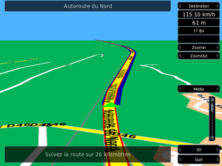
Turn-by-turn Navigation is a feature of some satellite navigation devices where directions for a selected route are continually presented to the user in the form of spoken or visual instructions. The system keeps the user up-to-date about the best route to the destination, and is often updated according to changing factors such as traffic and road conditions. Turn-by-turn systems typically use an electronic voice to inform the user whether to turn left or right, the street name, and the distance to the next turn.
Samyung ENC is a South Korean manufacturer of marine communication and navigation systems. The company is publicly listed and traded on the KOSDAQ.