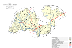
Nawanagar is a village and corresponding community development block situated in the Buxar district of Bihar, India,[4][5] and one of the developing settlements of the district. It is one of several minor villages governed and administered by the Nawanagar panchayat. The village has the only one police station among other nearby villages. Nawangar is one of the seven blocks making up the Dumraon sub-division.[5]
As of 2011, the population of Nawanagar is 8,521, in 1,429 households, while the total population of the block is 166,534, in 25,557 households.[3]
Geography
The village is situated in the lower part of Bihar.[5] Most of the area is agricultural land with rice as the main crop. Due to variations in annual rainfall, local farmers cannot depend on seasonal rain for irrigation, they utilizes the SoneCanal system for irrigation, particularly through the five main branches of the western canal and its tributaries.[6]
The River Ganga passes through the village, which is inaccessible during the summer. The river is the nearest (45 kilometres (28mi)) navigable inland waterway for mass transportation towards Kolkata in the east as well as parts of Uttar Pradesh.
Nawanagar is a rural block, with no major urban centres. The sex ratio of the block was 951 as of 2011, including a ratio of 941 among the 0-6 age group. Members of scheduled castes made up 14.59% of the block's population, and members of scheduled tribes made up 0.25%. The block's literacy rate was 66.57%, the lowest among sub-districts in Buxar district. Literacy was higher among men (78.76%) than women (53.78%).[3]
Most of the Nawanagar block workforce was employed in agriculture in 2011, with 28.73% being cultivators who owned or leased their own land and another 52.84% being agricultural labourers who worked someone else's land for wages. 2.69% were household industry workers, and the remaining 15.74% were other workers. Comparatively more men than women were cultivators and other workers, while comparatively more women than men were agricultural labourers and household industry workers.[3]
Transportion
Nawanagar has good road communications due to development efforts by the government. A state highway passes through the village connecting Sasaram and Buxar via Vikramganj and Maliyabagh. A national highway also passes through the outskirts.
At present the nearest railway station is at Dumraon, about 18 kilometres (11mi) from the village, which lies about 30 kilometres (19mi) from Buxar and 120 kilometres (75mi) from the capital city, Patna.
People and civil affairs
Most villagers are employed in agricultural work but due to improper education and a lack of skills, total production remains insufficient to satisfy the people.[citation needed]
Although there are two government based schools and four private schools, students must travel long distances to other cities and towns for higher and modern education. The Indian government has also introduced various anganwadi kendra to provide basic education for villagers.
Panchayat
The local panchayat consists of three villages: Nawanagar, Usra and Bhadkuda and includes a total of 13 panchayat polling booths. As of May2025[update] Hasbun Nisha is the current mukhiya(village head) of the panchayat.[7]
Infrastructure
The village does not have a comprehensive electricity supply but through the efforts of local governing bodies, solar panels have been introduced to provide power for street lighting.[8]
Villages
Nawanagar block contains the following 107 villages, of which 95 are inhabited and 12 are uninhabited:[3]
This page is based on this Wikipedia article Text is available under the CC BY-SA 4.0 license; additional terms may apply. Images, videos and audio are available under their respective licenses.