The Sunuwar or Koinch are a Tibeto-Burman ethnic group. a Kirati tribe native to Nepal, parts of India and southern Bhutan. They speak the Sunuwar language. According to the 2001 census of Nepal, 17% of the tribe follow the Kirant religion and adopt the Mundhum (Kiranti) culture.
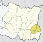
Ilam district is one of 14 districts of Koshi Province of eastern Nepal. It is a Hill district and covers 1,703 km2 (658 sq mi). The 2011 census counted 290,254 population. The municipality of Ilam is the district headquarters and is about 600 km (370 mi) from Kathmandu.

Baglung is a municipality in Gandaki Province, in western Nepal, 275 km (171 mi) west of Kathmandu. It is the administrative headquarters of Baglung District. Baglung serves as the major center for business, finance, education, service and healthcare for the people of mid-Kali Gandaki valley that encompass Beni, Jaljala, Baglung, Kushma, Kathekhola, Galkot, Phalewas and Jaimuni local bodies. The city is located at the cross-section of Kaligandaki corridor highway and midhill highway that transverse Nepal in north–south and east–west directions respectively.

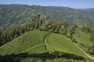
Ilam is one of four urban municipalities of Ilam District, which lies in the Mahabharata hilly range of Koshi Province, eastern Nepal. Ilam also acts as the headquarters of Ilam District. Being the largest producer region for Nepali tea, its tea farms are a major tourist attraction in Koshi Province. Ilam is also famous for its natural scenery and landscapes as well as its diverse agricultural economy which specializes in horticultural crop production.

The Prithvi Highway is a 174-kilometre-long (108 mi) highway connecting Naubise of Tribhuvan Highway, 26 km from Kathmandu, the capital of Nepal, and Prithivi Chowk, Pokhara, a tourist city in the western part of Nepal.

Mahendra Highway, also called East-West Highway runs across the Terai geographical region of Nepal, from Mechinagar in the east to Bhim Datta in the west, cutting across the entire width of the country. It is the longest highway in Nepal and was constructed by cooperation of various countries. The highway is named after king Mahendra Shah.
Juropani (जुरोपानी) is a village development committee of the Jhapa district of Nepal.

Bhimeshwar,, is a municipality in north-eastern Nepal and the headquarters of Dolakha District in Bagmati Province that was established in 1997 by merging the former Village development committees Charikot, Dolakha Town, Makaibari and Mati. At the time of the 2011 Nepal census it had a population of 32,486 people living in 8,639 individual households. The town is located at an altitude of 1554 metres (5101 feet). The name of the district Dolakha came from Dolakha Town situated north-east of the headquarters Charikot Bazaar.

Takukot is a Ward of Barpak sulikot Rural Municipality in Gorkha District in the Gandaki Province of northern-central Nepal. At the time of the 1991 Nepal census it had a population of 4,234 and had 801 houses in the town.
Jitpur is a town and Village Development Committee in Ilam District in the Province No. 1 of eastern Nepal. At the time of the 1991 Nepal census it had a population of 5,454 persons residing in 989 individual households.
Phakphok is a town and Village Development Committee (VDC) in Ilam District in the Province No. 1 of eastern Nepal. At the time of the 1991 Nepal census it had a population of 4,233 persons living in 734 individual households.
Sulubung is a Village Development Committee in Ilam District in the Province No. 1 of eastern Nepal. At the time of the 1991 Nepal census it had a population of 3,470. Maipokhari, one of the major tourist and religious place of Nepal lies here. A company named Hesty Kiwi Private Limited has been established in this region which had helped to popularize this village with the plantation of kiwifruit. It is about 15 km from Ilam Bazaar. It is a hilly area having cold climate and mainly tea production is the income of most of the people here.

Nijgadh, is a town and municipality in Nepal, located in Bara District of the Madhesh Province. The total area of the municipality is 289.4 sq. km. The municipality was formed on 8 May 2014 by merging Nijgadh VDC with Ratnapuri VDC and Bharatganj Singaul VDC.
Chaturale(Nepali:चतुराले) is a village in the Nuwakot District of Nepal. The Chaturale village lies in between two rivers, Dhade Khola and Sindure Khola. Chaturale is now located in Kakani Rural Municipality ward no 7. Chaturale is named after its founder, Chatur Bhuj Ale. The biggest occasion is mainly celebrated in Chaturale bazar.
Bhimad is a municipality in Tanahu District in the Gandaki Zone of central Nepal. At the time of the 2011 Nepal census the city had a population of 8,414 people living in 2,191 individual households. It is 30 minutes away from Khairenitar. Due to its historic importance, a plan is underway to incorporate the Shukla Gandaki municipality and form the Bhimad Sub-metropolitan City in the near future. This is being done in order to improve the integrated development of this region because the city is currently experiencing accelerated development. While Bhimad lacks sufficient hospital facilities for its population size, there are many health centers in various communities.
Bhaudaha is a village development committee in Morang District in the Kosi Zone of south-eastern Nepal. At the time of the 1991 Nepal census it had a population of 4743 people living in 876 individual households.
Sorabhag is a village development committee in Morang District in the Kosi Zone of south-eastern Nepal. At the time of the 1991 Nepal census it had a population of 7865 people living in 1605 individual households. Popular market called KARSIYA lies here. Rangeli raid passes through it.
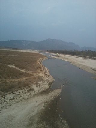
The Kankai River is a trans-boundary river flowing through the hills of Ilam and the plains of the Jhapa District in Nepal. It begins at the confluence of the Mai Khola and Deb Mai Khola rivers.
Tandlianwala is a city and Tehsil in Punjab, Pakistan. It is located 50 km from the city of Faisalabad and 44 km from city of Okara. It is a sub-division of Faisalabad District and has a Tehsil Municipal Administration (TMA).

Koshi Province is the autonomous easternmost province adopted on 20 September 2015 by Constitution of Nepal. The province is rich in natural resources, tourist attractions, recreational activities, and natural beauty. The province covers an area of 25,905 km2, about 17.5% of the country's total area. With the industrial city of Biratnagar as its capital, the province covers other major eastern towns including Birtamod, Birat Chowk, Damak, Dharan, Itahari, Triyuga and Mechinagar and includes several mountains including the Everest, Kangchenjunga, and Ama Dablam. Koshi River, the largest river of the nation, is the province's western boundary. Understanding of the first-past-the-post voting system issued by the Constituency Delimitation Commission, Nepal, the province hosts 28 parliamentary seats and 56 provincial assembly seats.