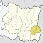
Ilam district is one of 14 districts of Koshi Province of eastern Nepal. It is a Hill district and covers 1,703 km2 (658 sq mi). The 2011 census counted 290,254 inhabitants. The municipality of Ilam is the district headquarters and is about 600 km (370 mi) from Kathmandu.

Khotang District is one of 14 districts of Koshi Province of eastern Nepal. The district, with Diktel as its district headquarters, covers an area of 1,591 km2 (614 sq mi) and has a population (2021) of 206,312. The district is bordered by Bhojpur District in the east, Udayapur District in the south, Okhaldhunga District in the west and Solukhumbu District in the North. In this district there are two municipalities and eight rural/urban municipalities.

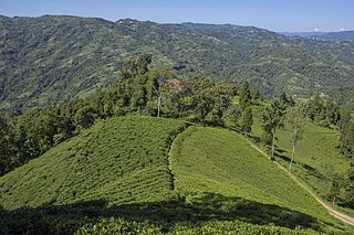
Ilam is one of four urban municipalities of Ilam District, which lies in the Mahabharata hilly range of Koshi Province, eastern Nepal. Ilam also acts as the headquarters of Ilam District. Being the largest producer region for Nepali tea, its tea farms are a major tourist attraction in Koshi Province. Ilam is also famous for its natural scenery and landscapes as well as its diverse agricultural economy which specializes in horticultural crop production.
Mechinagar is a municipality in Jhapa District, Koshi Province, Nepal and is the main entry point from India on Nepal's eastern border. Nepal's customs office is in Kakarvitta, a section of the municipality. The city lies 475 km southeast of the capital Kathmandu and 115 km east of Biratnagar, the capital of Province No. 1.
Siraha is the headquarters and municipality of Siraha District, a part of Madhesh Province, Nepal. Siraha had a population of 28,442 according to the census of 2011. and a population of 82,531 as of 2015. The current population of Siraha municipality as of census 2022, is 96,543. It has a male population of 47,306 and female population of 49,237. The present mayor of Siraha Municipality is Dr. Nabin Kumar Yadav and Deputy Mayor is Babita Kumari Sah. Both assumed office on 25 May 2022. His predecessor mayor was Asheswor Yadav and the deputy mayor was Dr. Namita Yadav. Both assumed office on 25 September 2017 and their last working day was on 24 May 2022. The town is at 80 metres (260 ft) altitude, 29 kilometres (18 mi) ESE of Janakpur.

A village development committee in Nepal was the lower administrative part of its Ministry of Federal Affairs and Local Development. Each district had several VDCs, similar to municipalities but with greater public-government interaction and administration. There were 3,157 village development committees in Nepal. Each village development committee was further divided into several wards depending on the population of the district, the average being nine wards.
Phakphok is a Village in Phakphokthum Rural Municipality of Ilam District in the Koshi Province of eastern Nepal. At the time of the 1991 Nepal census it had a population of 4,233 persons living in 734 individual households.
Fikkal or Phikkal Bazar is a former Village Development Committee (VDC) and now a part of Suryodaya Municipality in Ilam District, Koshi Province, Nepal.
Sangrumba साङरुम्बा is a town and Village Development Committee in Ilam District in the Province No. 1 of eastern Nepal. At the time of the 1991 Nepal census it had a population of 4,607 persons living in 839 individual households. According to the VDC report of 2068 BS, the total population was 6,288 and the total number of households was 1,227, an average of 5.12 members per household.

Nijgadh, is a town and municipality in Nepal, located in Bara District of the Madhesh Province. The total area of the municipality is 289.4 sq. km. The municipality was formed on 8 May 2014 by merging Nijgadh VDC with Ratnapuri VDC and Bharatganj Singaul VDC.
Chapakot is a municipality in the southeastern part of Syangja District in Gandaki Province of central Nepal. The new municipality was formed by merging three existing villages—Ratnapur, Kuwakot and Chapakot—on 18 May 2014. In 12 March 2017 The government implemented the new local administrative structure consisting of 744 local units. With the implementation of this new local administrative structure, the old structure will no longer be in existence. According to the new structure, VDCs will be replaced with village councils. Newly merged VDCs are Sankhar, Sekham, Ward no. 8 of Pakbadi & Ward no. of Malyangkot. The office of the municipality is that of the former Chapakot Municipality.

Suryodaya Municipality is a municipality located in Koshi Pradesh of Nepal in Ilam district. Suryodaya is the Nepali translation for “Sunrise".
Shivasatakshi is a municipality in the southeastern part of Jhapa District in the Koshi Province of eastern Nepal. The new municipality was formed by merging four existing VDCs—Shivaganj, Satasidham, Dharampur, and Panchgachhi—on 2 Dec 2014. The office of the municipality is that of the former Satasidham village development committee (VDC).
Rapti Municipality is a municipality which lies in Eastern part of Chitwan district in Bagmati Province of Nepal. It was formed as municipality in 2015 by merging five existing village development committees, Birendranagar VDC, Bhandara VDC, Piple VDC, Lothar VDC and Korak VDC. Total area of this municipality is 99.40 and population of this municipality according to 2068 BS census is 46510.
Phakphokthum is a rural municipality, one of six located in Ilam District of Koshi Province of Nepal. A total of 10 municipalities are found in Ilam, of which 4 are urban and 6 are rural.
Maijogmai is a rural municipality (gaunpalika) out of six rural municipality located in Ilam District of Province No. 1 of Nepal. There are a total of 10 municipalities in Ilam in which 4 are urban and 6 are rural.
Rong is a rural municipality out of six rural municipalities located in Ilam District of Province No. 1 of Nepal. There are a total of 10 municipalities in Ilam in which 4 are urban and 6 are rural.
Mangsebung is a rural municipality (gaunpalika) out of six rural municipality located in Ilam District of Province No. 1 of Nepal. There are a total of 10 municipalities in Ilam in which 4 are urban and 6 are rural.
Sandakpur is a rural municipality (gaunpalika) out of six rural municipality located in Ilam District of Province No. 1 of Nepal. There are a total of 10 municipalities in Ilam in which 4 are urban and 6 are rural.

Badimalika Municipality is a newly formed municipality in Bajura District in the Sudurpashchim Province of Nepal. It was formed in March, 2017 as decided by the Cabinet in line with the Constitution of Nepal 2015