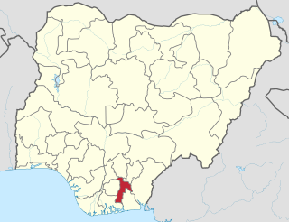
Abia State is a state in the South-East geopolitical zone of Nigeria, it is bordered to the northwest by Anambra State and northeast by the states of Enugu, and Ebonyi, Imo State to the west, Cross River State to the east, Akwa Ibom State to the southeast, and Rivers State to the south. Abia is the only Southeastern state that has boundaries with the other four Southeastern states in Nigeria. It takes its name from the acronym for four of the state's most populated regions: Aba, Bende, Isuikwuato, and Afikpo. The state capital is Umuahia while the largest city and commercial centre is Aba.
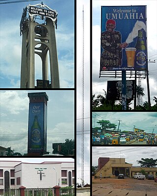
Umuahia is the capital city of Abia State in southeastern Nigeria. Umuahia is located along the rail road that lies between Port Harcourt to its south,and Enugu city to its north. Umuahia has a population of 359,230 according to the 2006 Nigerian census. Umuahia is indigenously Igbo.
Arochukwu Local Government Area, sometimes referred to as Arochuku or Aro Oke-Igbo, is the third largest local government area in Abia State in southeastern Nigeria and homeland of the Igbo subgroup, Aro people.

Ebonyi State is a state in the South-East geopolitical zone of Nigeria, bordered to the north and northeast by Benue State, Enugu State to the west, Cross River State to the east and southeast, and Abia State to the southwest. Named for the Abonyi (Aboine) River—a large part of which is in the state's south—Ebonyi State was formed from parts of Abia and Enugu state in 1996 and has its capital as Abakaliki.

Abia State University Uturu (ABSU) is a Nigerian public university. It is one of the state-owned universities in Nigeria. These state academic institutions were created to expand admissions and bring professional skills, expertise and modern research facilities close to the city and rural dwellers, and have helped talented students to obtain higher education.

Moore's Crossing Historic District is a community located in rural Travis County nine miles southeast of Austin, Texas near the Austin–Bergstrom International Airport.
Bende is a Local Government Area in Abia State, Nigeria with headquarters located in Bende Community. Bende Local Government Area (L.G.A) of Abia state lies on 70 30I of the Greenwich Meridian and latitude 50 30I North of the Equator. It is composed of thirteen (13) communities, namely: Alayi, Bende, Ezukwu, Igbere, Item, Itumbuzo, Nkpa, Ntalakwu, Ozuitem, Ugwueke, Umu-imenyi, Umuhu-Ezechi, and Uzuakoli.
Ohafia is an Igbo town in the Ohafia local government area (LGA) in Abia State, Nigeria. It is an Igbo speaking region. The ancestral capital of Ohafia town is the centrally located village of Elu. Ohafia Local Government Area, is an administrative jurisdiction assigned by the Nigeria Government, which covers the entire Ohafia villages and other towns such as Abiriba and Nkporo, with its Administrative Headquarters at Ebem Ohafia.
Ini is located in the south of Nigeria and is a local government area of Akwa Ibom State.
Ikwuano is a Local Government Area of Abia State, Nigeria. Its headquarters is in Isiala Oboro. The name 'Ikwuano' etymologically indicates that there are four different ancient kingdoms that make up the community called Ikwuano. These include Oboro, Ibere, Ariam/Usaka and Oloko.

Ukwa West is a Local Government Area in Abia State, Nigeria. Its headquarters is in the town of Oke Ikpe.
Ozu Abam is a town in Arochukwu local government area, Abia State, Nigeria, populated by people from the Abam clan.
Elemaga is a small farming village in Ibere, Ikwuano, Abia State, Nigeria. Elemaga is located in the center of Inyila, Isiala Ibere, Ahia Orie, Iberenta, Itunta and Obuoru at the food belt of Ibere, about 15 km southwest of Umuahia, the Abia State capital. Elemaga is believed to be derived syntactically from the words Ele ("look"), Ma ("well") and Ga ("go") which literally means "look well before you go". Climate is tropical monsoon.
Oboro is the largest of four clans in Ikwuano Local Government Area of Abia State, Nigeria. It is bounded to the north by Ibeku and Bende clans, west by the Olokoro and Ngwa, east by Ibere and south by the Isuogu. Oboro was classified in the Ohuhu-Ngwa cluster of the Southern Igbo area by British anthropologists Forde and Jones. It is also one of 18 Igbo clans in the Old Bende Division of the defunct Owerri Province. The Oboro speak a common language with the other 17 clans of the Bende Division though dialectal variations exist. These clans share a history of inter-ethnic relations.
Ndoro is a town in Oboro, Ikwuano Local Government Area of Abia State, Nigeria. It is about 16 km southeast from the state capital, Umuahia and is located along the Umuahia-Ikot Ekpene Road.
Abia is a town in Enugu State, Nigeria.
Ibere is a clan located in the eastern part of Ikwuano Local Government Area, Abia State, Nigeria. It borders Oboro to the west, Bende to the north, the Isuogu to the south, Itumbauzo and Nkari to the east. It is one of 18 Igbo clans of the Old Bende Division. Ibere was classified in the Ohuhu-Ngwa cluster of the Southern Igbo area by Forde and Jones.
Nchara is an agrarian community in Oloko, Ikwuano Local Government Area, Abia State, Nigeria. It is composed of two sister villages namely; Akanu and Etoruo. Afa Ukwu is the autonomous community of Nchara. It is about 24 km away from the state capital, Umuahia.
Itunta is a village in Ibere, Ikwuano Local Government Area, Abia State, Nigeria. Itunta falls under the Umuakoo Autonomous Community. The Eze of Umuakoo is HRM Eze Monday Unadindu Okoro in whom is conferred with the title of Akoo II of Umuakoo. Itunta is renowned for her vast cocoa production.