
Manitoba is a province of Canada at the longitudinal centre of the country. It is Canada's fifth-most populous province, with a population of 1,342,153 as of 2021. Manitoba has a widely varied landscape, from arctic tundra and the Hudson Bay coastline in the north to dense boreal forest, large freshwater lakes, and prairie grassland in the central and southern regions.

The Interlake Region is an informal geographic region of the Canadian province of Manitoba that lies roughly between Lake Winnipeg and Lake Manitoba in the Canadian province of Manitoba.
Ethelbert is an unincorporated urban community in the Municipality of Ethelbert, Manitoba, Canada.
Mystery Lake is a local government district (LGD) in northern Manitoba. It surrounds the city of Thompson, although most of its territory lies to the southwest and south of the city. It is named after Mystery Lake, a lake located in the northeast section of the LGD, northeast of Thompson.
Beaver Creek Provincial Park is a provincial park on Lake Winnipeg near the mouth of Beaver Creek in the North Interlake Region of Manitoba, Canada.
Treaty 2 was entered in to on 21 August 1872 at Manitoba House, Rupertsland, with representatives of the Queen of Great Britain and Ireland. The original Anishinaabe, who were present, constitute Treaty 2 today. It is known that many of the chiefs and leaders within the territory were at the early gathering and after the treaty was agreed to. Those who were not present were represented through Metis until they indicated where they wished their farming reserves to be established. The treaty reaffirmed the inherent rights that the Anishinaabe had prior to European contact, located where southwestern Manitoba is today and a small part of southeastern Saskatchewan.
Highway 167 is a provincial highway in the Canadian province of Saskatchewan. It runs from the Manitoba border between Creighton and Flin Flon, where it takes over from Manitoba Highway 10, to the Amiskosakahikan Indian reserve on the southern shore of Amisk Lake. It is about 49 kilometres (30 mi) long.
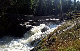
Wekusko Falls Provincial Park is a provincial park straddling the Grass River and Wekusko Lake, located in central Manitoba on Manitoba Provincial Road 392 near Snow Lake, Manitoba.
Fox Lake Cree Nation is a First Nations band government whose reserve is located in Fox Lake, Bird, Manitoba, Canada.

Alonsa is a rural municipality (RM) in the province of Manitoba, western Canada. It lies on the west side of Lake Manitoba.
The Porcupine Hills refer to various groups of hills and uplands located in the prairie provinces of Canada, specifically the provinces of Saskatchewan and Manitoba. They are part of the Manitoba Escarpment, which was the shoreline of the ancient glacial Lake Agassiz. The hills are located north-west of Swan River, Manitoba, and are the headwaters of the Swan River. The highest elevation in the Porcupine Hills is Hart Mountain, at an elevation of 823 metres (2,700 ft), which makes it Manitoba's second-highest point. The Porcupine Provincial Forest surrounds the area.
The Municipality of Shoal Lake is a former rural municipality (RM) in the Canadian province of Manitoba. It was originally incorporated as a rural municipality on January 1, 2011. It ceased on January 1, 2015, as a result of its provincially mandated amalgamation with the RM of Strathclair to form the Rural Municipality of Yellowhead.
Clearwater Lake Provincial Park was designated a provincial park by the Government of Manitoba in 1963. The park is 593 square kilometres (229 sq mi) in size. The park is considered to be a Class II protected area under the IUCN protected area management categories.

Bakers Narrows Provincial Park is a provincial park south of Flin Flon in the Northern Region of Manitoba, Canada. It is 145 hectares (0.56 sq mi) in size. It was designated as a provincial park in 1961.
Bell Lake Provincial Park is a provincial park on the north shore of Bell Lake in the Porcupine Provincial Forest, Manitoba, Canada. It is 4 hectares in size. It was designated as a provincial park in 1974.
Manipogo Provincial Park is a provincial park on the shore of Lake Manitoba, approximately 50 km (31 mi), northeast of Dauphin, Manitoba. It is named after Manipogo, a lake monster reputed to live in the lake.
Baralzon Lake Ecological Reserve is an ecological reserve in the area surrounding the portion of Baralzon Lake within Manitoba, Canada. It was established in 1989 under the Manitoba Ecological Reserves Act. It is 396 square kilometres (153 sq mi) in size.
Lake St. George Caves Ecological Reserve is an ecological reserve located west of Lake Winnipeg, Manitoba, Canada. It was established in 1997 under the Manitoba Ecological Reserves Act. It is .49 square kilometres (0.19 sq mi) in size.
Lake Winnipegosis Salt Flats Ecological Reserve is an ecological reserve located on the west of Lake Winnipegosis, Manitoba, Canada. It was established in 1992 under the Manitoba Ecological Reserves Act. It is 47.25 square kilometres (18.24 sq mi) in size.

