
The Reclamation Act of 1902 is a United States federal law that funded irrigation projects for the arid lands of 17 states in the American West.

Milk River is a tributary of the Missouri River, 729 miles (1,173 km) long, in the U.S. state of Montana and the Canadian province of Alberta. Rising in the Rocky Mountains, the river drains a sparsely populated, semi-arid watershed of 23,800 square miles (62,000 km2), ending just east of Fort Peck, Montana.

The Pick–Sloan Missouri Basin Program, formerly called the Missouri River Basin Project, was initially authorized by the Flood Control Act of 1944, which approved the plan for the conservation, control, and use of water resources in the Missouri River Basin.

Elephant Butte Dam or Elephant Butte Dike, originally Engle Dam, is a concrete gravity dam on the Rio Grande near Truth or Consequences, New Mexico, in the United States. The dam impounds Elephant Butte Reservoir, which is used mainly for agriculture but also provides for recreation, hydroelectricity, and flood and sediment control. The construction of the dam has reduced the flow of the Rio Grande to a small stream for most of the year, with water being released only during the summer irrigation season or during times of exceptionally heavy snow melt.
Gibson Reservoir is a man-made body of water located just south of the Bob Marshall Wilderness, 20 miles (32 km) northwest of Augusta, Montana. It forms part of the county line between Teton and Lewis & Clark counties. The reservoir is formed by the concrete arch Gibson Dam and backs water up between a hilly pass for about 3 miles. The water in the dam is initially provided by spring snow runoff and carried there via the North Fork Sun River and the South Fork Sun River right after the two join. The reservoir is mainly used for irrigation control.
Lake Sherburne is located in the Many Glacier region of Glacier National Park, in the U.S. state of Montana. The lake is a reservoir, formed by Lake Sherburne Dam, which held back Swiftcurrent Creek and was constructed between 1914 and 1921. The construction of the dam filled up several small lakes and highly productive river transition and wetland areas, and due to its fluctuating water levels, the surrounding area supports little vegetation. However, trumpeter swans are often observed along the lake in the spring and fall. The lake stretches nearly 6 mi (9.7 km) when full. The reservoir is the principal water storage component of the U.S. Bureau of Reclamation's Milk River Project, which provides irrigation water to north central Montana farms.

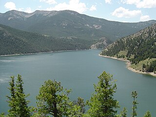
Clark Canyon Dam is an earthfill dam located in Beaverhead County, Montana, about 20 miles (32 km) south of the county seat of Dillon. The dam impounds the waters of the Beaverhead River, creating a body of water known as Clark Canyon Reservoir. The structure was constructed in 1961-1964 by the United States Bureau of Reclamation, to hold water for downstream irrigation and for flood control purposes.
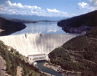
Hungry Horse Dam is an arch dam in the Western United States, on the South Fork Flathead River in the Rocky Mountains of northwest Montana. It is located in Flathead National Forest in Flathead County, about fifteen miles (24 km) south of the west entrance to Glacier National Park, nine miles (14 km) southeast of Columbia Falls, and twenty miles (32 km) northeast of Kalispell. The Hungry Horse project, dam, and powerplant are operated by the U.S. Bureau of Reclamation. The entrance road leading to the dam is located in Hungry Horse.

Yellowtail Dam is a dam across the Bighorn River in south central Montana in the United States. The mid-1960s era concrete arch dam serves to regulate the flow of the Bighorn for irrigation purposes and to generate hydroelectric power. The dam and its reservoir, Bighorn Lake, are owned by the U.S. Bureau of Reclamation.

Lake Cascade, is a reservoir in the western United States, on the North Fork of the Payette River in Valley County, Idaho. Located in the Boise National Forest, it has a surface area of 47 square miles (122 km2), and is the fourth largest lake or reservoir in the state. The closest cities are Cascade, Donnelly, and McCall, all in the Long Valley of Valley County.

Anderson Ranch Dam is an earth rockfill type dam in the western United States, on the South Fork of the Boise River in southwestern Idaho. In Elmore County northeast of Mountain Home, it is several miles north of U.S. Route 20 and operated by the U.S. Bureau of Reclamation.

El Vado Dam impounds the Rio Chama in the U.S. state of New Mexico, about 105 miles (169 km) north-northwest of New Mexico's largest city, Albuquerque and about 80 miles (130 km) northwest of the capital city of Santa Fe. The earth-filled structure forms El Vado Lake, a storage reservoir for the Middle Rio Grande Project, and has been designated as a New Mexico Historic Civil Engineering Landmark by the American Society of Civil Engineers.
Lake Sherburne Dam is a 107-foot (33 m) high compacted earthfill dam built between 1914 and 1921, just outside the boundary of Glacier National Park, Montana, its reservoir extending into the park. The dam impounds Swiftcurrent Creek as it flows out of the park. Water stored in Lake Sherburne is released to flow down Swiftcurrent Creek to the St. Mary River, from which it is diverted to the Milk River, flowing through Canada for 216 mi (348 km) before returning to the United States. Use of these waters is governed by the Boundary Waters Treaty of 1909. Water from the Milk River is used for irrigation in north central Montana.

Lovewell Reservoir is a reservoir in Jewell County, Kansas, United States. Built and managed by the U.S. Bureau of Reclamation, it is used for flood control, irrigation, and recreation. Lovewell State Park is located on its north shore.

Kirwin Reservoir is a reservoir in Phillips County, Kansas, United States. It is located next to the city of Kirwin in northern Kansas. The U.S. Bureau of Reclamation built it and continues to operate it for the purposes of flood control and area irrigation. The Kirwin National Wildlife Refuge lies on its shores.

Gibson Dam is a concrete arch dam on the Sun River, a tributary of the Missouri River, about 60 miles (97 km) west of Great Falls, Montana in the United States. Located on the eastern edge of the Rocky Mountains, the dam was built by the U.S. Bureau of Reclamation (USBR) between 1926 and 1929 as part of the Sun River Project to develop about 93,000 acres (38,000 ha) of irrigated land in the Sun River Valley.
Willow Creek Dam is a dam in Lewis and Clark County, Montana.

Platoro Dam is a dam in Conejos County, Colorado.
