Saco, Montana

Last updated

Saco, Montana
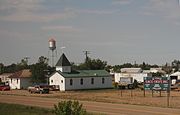
Saco Montana Panorama 2.jpg
Downtown Saco
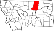
Phillips County Montana Incorporated and Unincorporated areas Saco Highlighted.svg
Location of Saco, Montana
Coordinates: 48°27′25″N107°20′29″W / 48.45694°N 107.34139°W / 48.45694; -107.34139
Country United States
State Montana
County Phillips
Area
[1]
  Total
0.30 sq mi (0.79 km2)
  Land0.30 sq mi (0.79 km2)
  Water0.00 sq mi (0.00 km2)
Elevation
[2]
2,182 ft (665 m)
Population
 (2020)
  Total
159
  Density523.03/sq mi (201.97/km2)
Time zone UTC-7 (Mountain (MST))
  Summer (DST) UTC-6 (MDT)
ZIP code
59261
Area code 406
FIPS code 30-65050
GNIS feature ID2412590 [2]
Website www.sacomontana.net

Saco is a town in Phillips County, Montana, United States. The population was 159 at the 2020 census. [3]

Contents

Geography

According to the United States Census Bureau, the town has a total area of 0.33 square miles (0.85 km2), all land. [4]

Climate

According to the Köppen Climate Classification system, Saco has a semi-arid climate, abbreviated "BSk" on climate maps. [5]

Climate data for Saco, Montana, 1991–2020 normals, extremes 1966–present
MonthJanFebMarAprMayJunJulAugSepOctNovDecYear
Record high °F (°C)62
(17)
72
(22)
79
(26)
92
(33)
100
(38)
104
(40)
104
(40)
105
(41)
100
(38)
89
(32)
78
(26)
67
(19)
105
(41)
Mean maximum °F (°C)48.5
(9.2)
51.2
(10.7)
66.0
(18.9)
79.6
(26.4)
85.6
(29.8)
91.3
(32.9)
95.5
(35.3)
96.2
(35.7)
91.1
(32.8)
80.3
(26.8)
64.1
(17.8)
48.9
(9.4)
98.1
(36.7)
Mean daily maximum °F (°C)25.6
(−3.6)
30.1
(−1.1)
42.8
(6.0)
57.3
(14.1)
67.5
(19.7)
74.3
(23.5)
82.8
(28.2)
82.1
(27.8)
71.5
(21.9)
57.2
(14.0)
40.8
(4.9)
29.0
(−1.7)
55.1
(12.8)
Daily mean °F (°C)13.6
(−10.2)
17.8
(−7.9)
30.1
(−1.1)
43.2
(6.2)
53.7
(12.1)
62.3
(16.8)
69.0
(20.6)
67.6
(19.8)
56.9
(13.8)
43.4
(6.3)
28.7
(−1.8)
17.4
(−8.1)
42.0
(5.5)
Mean daily minimum °F (°C)1.5
(−16.9)
5.5
(−14.7)
17.4
(−8.1)
29.1
(−1.6)
39.9
(4.4)
50.4
(10.2)
55.2
(12.9)
53.1
(11.7)
42.3
(5.7)
29.7
(−1.3)
16.6
(−8.6)
5.9
(−14.5)
28.9
(−1.7)
Mean minimum °F (°C)−27.4
(−33.0)
−19.5
(−28.6)
−6.3
(−21.3)
14.1
(−9.9)
25.8
(−3.4)
39.6
(4.2)
45.6
(7.6)
41.1
(5.1)
28.7
(−1.8)
13.7
(−10.2)
−5.7
(−20.9)
−19.4
(−28.6)
−33.3
(−36.3)
Record low °F (°C)−51
(−46)
−45
(−43)
−34
(−37)
−5
(−21)
14
(−10)
28
(−2)
34
(1)
31
(−1)
17
(−8)
−9
(−23)
−37
(−38)
−48
(−44)
−51
(−46)
Average precipitation inches (mm)0.26
(6.6)
0.33
(8.4)
0.53
(13)
1.05
(27)
1.77
(45)
3.01
(76)
1.69
(43)
1.35
(34)
1.35
(34)
1.05
(27)
0.54
(14)
0.43
(11)
13.36
(339)
Average snowfall inches (cm)4.3
(11)
4.9
(12)
7.0
(18)
2.3
(5.8)
0.4
(1.0)
0.0
(0.0)
0.0
(0.0)
0.0
(0.0)
0.0
(0.0)
0.0
(0.0)
0.5
(1.3)
2.3
(5.8)
4.9
(12)
Average extreme snow depth inches (cm)6.6
(17)
6.5
(17)
4.5
(11)
1.8
(4.6)
0.6
(1.5)
0.0
(0.0)
0.0
(0.0)
0.0
(0.0)
0.0
(0.0)
1.0
(2.5)
2.8
(7.1)
5.7
(14)
9.0
(23)
Average precipitation days (≥ 0.01 in)3.73.23.55.47.19.66.65.05.13.93.43.860.3
Average snowy days (≥ 0.1 in)3.23.61.20.30.00.00.00.00.00.21.23.212.9
Source 1: NOAA [6]
Source 2: National Weather Service [7]

History

Faced with the task of naming hundreds of station stops along the High Line, Great Northern Railway officials resorted to "globe trotting." According to one story, an official spun a globe and put his finger on Saco, Maine, thus giving the town its name. [8] Another story tells that the name is a contraction of "Sacajawea." [8] For two years, Saco boasted the Guinness world record for making the world's largest hamburger, building the 6,040-pound burger from the beef of 17 cattle in 1999. [9]

Demographics

Historical population
CensusPop.Note
1920 425
1930 50619.1%
1940 452−10.7%
1950 53919.2%
1960 490−9.1%
1970 356−27.3%
1980 252−29.2%
1990 2613.6%
2000 224−14.2%
2010 197−12.1%
2020 159−19.3%
U.S. Decennial Census [10] [3]

2010 census

As of the census [11] of 2010, there were 197 people, 102 households, and 47 families residing in the town. The population density was 597.0 inhabitants per square mile (230.5/km2). There were 127 housing units at an average density of 384.8 per square mile (148.6/km2). The racial makeup of the town was 94.4% White, 1.0% Asian, and 4.6% from two or more races. Hispanic or Latino of any race were 0.5% of the population.

There were 102 households, of which 24.5% had children under the age of 18 living with them, 39.2% were married couples living together, 4.9% had a female householder with no husband present, 2.0% had a male householder with no wife present, and 53.9% were non-families. 47.1% of all households were made up of individuals, and 23.6% had someone living alone who was 65 years of age or older. The average household size was 1.93 and the average family size was 2.83.

The median age in the town was 48.1 years. 21.3% of residents were under the age of 18; 2.1% were between the ages of 18 and 24; 22.4% were from 25 to 44; 33% were from 45 to 64; and 21.3% were 65 years of age or older. The gender makeup of the town was 50.3% male and 49.7% female.

2000 census

As of the census [12] of 2000, there were 224 people, 109 households, and 57 families residing in the town. The population density was 683.9 inhabitants per square mile (264.1/km2). There were 135 housing units at an average density of 412.2 per square mile (159.2/km2). The racial makeup of the town was 96.43% White, 1.79% Native American, and 1.79% from two or more races.

There were 109 households, out of which 23.9% had children under the age of 18 living with them, 41.3% were married couples living together, 8.3% had a female householder with no husband present, and 46.8% were non-families. 44.0% of all households were made up of individuals, and 22.9% had someone living alone who was 65 years of age or older. The average household size was 2.06 and the average family size was 2.84.

In the town, the population was spread out, with 23.7% under the age of 18, 3.6% from 18 to 24, 26.3% from 25 to 44, 24.6% from 45 to 64, and 21.9% who were 65 years of age or older. The median age was 43 years. For every 100 females there were 98.2 males. For every 100 females age 18 and over, there were 94.3 males.

The median income for a household in the town was $23,125, and the median income for a family was $26,667. Males had a median income of $23,125 versus $24,375 for females. The per capita income for the town was $16,421. About 14.3% of families and 14.0% of the population were below the poverty line, including 22.0% of those under the age of eighteen and 13.2% of those 65 or over.

Education

Saco School District educates students from kindergarten through 12th grade. [13] Saco High School's team name is the Panthers. [14]

Phillips County Library has a branch location in Saco. [15]

Media

The Phillips County News is a weekly local newspaper. [16] They provide a printed paper as well as news online.

Transportation

Amtrak’s Empire Builder, which operates between Seattle/Portland and Chicago, passes through the town on BNSF tracks, but makes no stop. The nearest station is located in Malta, 28 miles (45 km) to the west.

Notable people

Images

Related Research Articles

<span class="mw-page-title-main">Hiram, Maine</span> Town in the state of Maine, United States

Hiram is a town in Oxford County, Maine, United States. The population was 1,609 at the 2020 census. It includes the villages of Hiram, East Hiram, South Hiram and Durgintown. Located among the rugged and unspoiled Western Maine Mountains, Hiram is part of the Portland-South Portland-Biddeford, Maine metropolitan New England city and town area.

<span class="mw-page-title-main">Dayton, Maine</span> Town in the state of Maine, United States

Dayton is a town in York County, Maine, United States; the town is located near the Saco-Biddeford city area. Dayton borders Biddeford by land, and borders Saco on the Saco River. It is also part of the Portland–South Portland–Biddeford, Maine metropolitan statistical area. The population was 2,129 at the 2020 census. Dayton is one of the smallest towns in York County.

<span class="mw-page-title-main">Hollis, Maine</span> Town in the state of Maine, United States

Hollis is a town in York County, Maine, United States. The population was 4,745 at the 2020 census. Hollis is a rural bedroom community of Portland and is part of the Portland–South Portland–Biddeford metropolitan statistical area.

<span class="mw-page-title-main">Simms, Montana</span> CDP in Montana, United States

Simms is a census-designated place (CDP) in Cascade County, Montana, United States. The population was 354 at the 2010 census. It is part of the Great Falls, Montana Metropolitan Statistical Area.

<span class="mw-page-title-main">Big Sandy, Montana</span> Town in Montana, United States

Big Sandy is a town in Chouteau County, Montana, United States. The population was 605 at the 2020 census.

<span class="mw-page-title-main">Carter, Montana</span> Census-designated place in Montana, United States

Carter is a census-designated place (CDP) in Chouteau County, Montana, United States. The population was 58 at the 2010 census.

<span class="mw-page-title-main">Moore, Montana</span> Town in Montana, United States

Moore is a town in Fergus County, Montana, United States. The population was 194 at the 2020 census.

<span class="mw-page-title-main">Winifred, Montana</span> Town in Montana, United States

Winifred is a small town in rural north-central Fergus County, Montana, United States. It was founded in 1913 and provides services for its region's populace. The town population was 172 at the 2020 census. The current mayor is Travis Willson.

<span class="mw-page-title-main">Coram, Montana</span> Unincorporated community in Montana, United States

Coram is an unincorporated community and census-designated place (CDP) in Flathead County, Montana, United States. The population was 539 in 2010, up from 337 at the 2000 census. Coram lies 7 miles (11 km) southwest of the western entrance of Glacier National Park.

<span class="mw-page-title-main">Ryegate, Montana</span> Town in Montana, United States

Ryegate is a town in, and the county seat of, Golden Valley County, Montana, United States. The population was 223 at the 2020 census. Ryegate is situated on the north bank of the Musselshell River.

<span class="mw-page-title-main">Hingham, Montana</span> Town in Montana, United States

Hingham is a town in Hill County, Montana, United States. Its economy is largely agricultural. The population was 131 at the 2020 census.

<span class="mw-page-title-main">Augusta, Montana</span> Census-designated place in Montana, United States

Augusta is an unincorporated community and census-designated place (CDP) in Lewis and Clark County, Montana, United States. The population was 309 at the 2010 census and rose to 316 in the 2020 census. The most accepted version in the naming of this town is after Augusta Hogan, thought to be the first child born in this town, the daughter of J. D. Hogan, an early rancher.

<span class="mw-page-title-main">Rexford, Montana</span> Town in Montana, United States

Rexford is a town in Lincoln County, Montana, United States. The population was 78 at the 2020 census.

<span class="mw-page-title-main">Twin Bridges, Montana</span> Town in Montana, United States

Twin Bridges is a town in Madison County, Montana, United States. It lies at the confluence of the Ruby, Beaverhead and Big Hole rivers which form the Jefferson River. Twin Bridges is a well-known fly fishing mecca for trout anglers. The population was 330 at the 2020 census.

<span class="mw-page-title-main">Dodson, Montana</span> Town in Montana, United States

Dodson is a town in Phillips County, Montana, United States. The population was 125 at the 2020 census.

<span class="mw-page-title-main">Malta, Montana</span> City in Montana, United States

Malta is a city in, and the county seat of, Phillips County, Montana, United States, located at the intersection of U.S. Routes 2 and 191. The population was 1,860 at the 2020 census.

<span class="mw-page-title-main">Nashua, Montana</span> Town in Montana, United States

Nashua is a town in Valley County, Montana, United States. The population was 301 at the 2020 census.

<span class="mw-page-title-main">Broadview, Montana</span> Town in Montana, United States

Broadview is a town in Yellowstone County, Montana, United States. The population was 139 at the 2020 census.

<span class="mw-page-title-main">Denton, Montana</span> Town in Fergus County, Montana, United States

Denton is a town in Fergus County, Montana, United States. The population was 205 at the 2020 census.

<span class="mw-page-title-main">Epping, North Dakota</span> City in North Dakota, United States

Epping is a city in Williams County, North Dakota, United States. The population was 84 at the 2020 census.

References

  1. "ArcGIS REST Services Directory". United States Census Bureau. Retrieved September 5, 2022.
  2. 1 2 U.S. Geological Survey Geographic Names Information System: Saco, Montana
  3. 1 2 "U.S. Census website". United States Census Bureau . Retrieved November 2, 2021.
  4. "US Gazetteer files 2010". United States Census Bureau. Archived from the original on July 2, 2012. Retrieved December 18, 2012.
  5. "Saco, Montana Climate Classification". Weatherbase. Retrieved April 29, 2024.
  6. "U.S. Climate Normals Quick Access – Station: Saco 1NNW, MT". National Oceanic and Atmospheric Administration. Retrieved December 29, 2022.
  7. "NOAA Online Weather Data – NWS Glasgow". National Weather Service. Retrieved December 29, 2022.
  8. 1 2 "Saco". Montana Place Names Companion. Montana Historical Society. Retrieved April 9, 2021.
  9. Aarstad, Rich, Ellie Arguimbau, Ellen Baumler, Charlene Porsild, and Brian Shovers. Montana Place Names from Alzada to Zortman Archived October 8, 2009, at the Wayback Machine . Montana Historical Society Press.
  10. "Census of Population and Housing". Census.gov. Retrieved June 4, 2015.
  11. "U.S. Census website". United States Census Bureau . Retrieved December 18, 2012.
  12. "U.S. Census website". United States Census Bureau . Retrieved January 31, 2008.
  13. "Saco School District". Saco School District. Retrieved April 13, 2021.
  14. "Member Schools". Montana High School Association. Retrieved April 19, 2021.
  15. "Phillips County Library". Montana State Library. Retrieved April 13, 2021.
  16. "News". Phillips County News. Retrieved January 2, 2024.
  17. "Montana House of Representatives - 60th Legislature - 2007" (PDF). leg.mt.gov. Retrieved June 17, 2023.