
Sarıkavak is a neighbourhood in the municipality and district of Çamlıyayla, Mersin Province, Turkey. Its population is 677 (2022). It is on the road connecting Çamlıyayla to Tarsus and Mersin. Distance to Çamlıyayla is 17 kilometres (11 mi) to Tarsus is 40 kilometres (25 mi) and to Mersin is 69 kilometres (43 mi). The popular hiking course and the canyon Kisecik Canyon is to the west of the village. Sarıkavak is a typical agricultural village where vegetable and olive are the most important crops. Some residents also work in cotton fields around Tarsus, Mersin, and Adana.
Arıklı is a neighbourhood in the municipality and district of Tarsus, Mersin Province, Turkey. Its population is 175 (2022). It is situated in the Çukurova (Cilicia) plains. It is on the state highway D.400, east of Mersin, Tarsus and Yenice. It is the easternmost village of the province. The distance to Tarsus is 19 kilometres (12 mi) and to Mersin is 46 kilometres (29 mi).
Hacıhamzalı is a neighbourhood in the municipality and district of Tarsus, Mersin Province, Turkey. Its population is 1,204 (2022). It is to the north of Tarsus and Berdan Dam reservoir. Its distance to Tarsus is 28 kilometres (17 mi) and to Mersin is 55 kilometres (34 mi).
Aliağa is a neighbourhood in the municipality and district of Tarsus, Mersin Province, Turkey. Its population is 439 (2022). It is situated in Çukurova plains to the east of Karabucak Forest. The distance to Tarsus is 12 kilometres (7.5 mi) and the distance to Mersin is 37 kilometres (23 mi).
Aliefendioğlu is a neighbourhood in the municipality and district of Tarsus, Mersin Province, Turkey. Its population is 930 (2022). It is situated in Çukurova plains to the south of Tarsus. The distance to Tarsus is 4 kilometres (2.5 mi) and the distance to Mersin is 28 kilometres (17 mi).
Alifakı is a neighbourhood in the municipality and district of Tarsus, Mersin Province, Turkey. Its population is 6,551 (2022). It is situated in Çukurova plains to the southeast of Tarsus. The distance to Tarsus is 13 kilometres (8.1 mi) and the distance to Mersin is 38 kilometres (24 mi).
Baharlı is a neighbourhood in the municipality and district of Tarsus, Mersin Province, Turkey. Its population is 277 (2022). It is situated to the west of Berdan River and about 4 kilometres (2.5 mi) north of the Mediterranean Sea coast. Its distance to Tarsus is 28 kilometres (17 mi) and to Mersin is 58 kilometres (36 mi).
Çamtepe is a neighbourhood in the municipality and district of Tarsus, Mersin Province, Turkey. Its population is 251 (2022). It is situated in Çukurova to the northeast of Tarsus and between Turkish motorway O.31 and Turkish state highway D.750. Its distance to Tarsus is 9 kilometres (5.6 mi) and to Mersin is 38 kilometres (24 mi).
Çağbaşı is a neighbourhood in the municipality and district of Tarsus, Mersin Province, Turkey. Its population is 492 (2022). It is situated in Çukurova to the southeast of Tarsus. The distance to Tarsus is 17 kilometres (11 mi) and the distance to Mersin is 47 kilometres (29 mi). The village is situated in a fertile area and the main products are grapes and cotton.
Tepetaşpınar is a neighbourhood in the municipality and district of Tarsus, Mersin Province, Turkey. Its population is 192 (2022). It is situated in the Toros Mountains. It is 40 kilometres (25 mi) to Tarsus and 60 kilometres (37 mi) to Mersin.
Çavdarlı is a neighbourhood in the municipality and district of Tarsus, Mersin Province, Turkey. Its population is 280 (2022). It is in the southern slopes of the Taurus Mountains and to the north of Tarsus. It is situated to the northwest of Berdan Dam reservoir and to the south of Keşbükü creek a branch of Berdan River. Its distance to Tarsus is 28 kilometres (17 mi) and to Mersin is 55 kilometres (34 mi). The population is on decrease because of migration to cities. Major economic activity of the village is fruit farming. Grape and olive are the main crops. Beehiving and poultry husbandry are secondary activities.
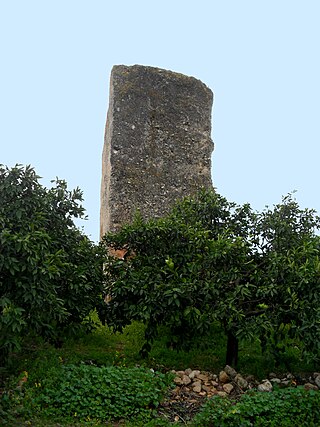
Dikilitaş is a neighbourhood in the municipality and district of Akdeniz, Mersin Province, Turkey. Its population is 1,069 (2022). It takes its name from an ancient Assyrian monument.
Verimli is a neighbourhood in the municipality and district of Tarsus, Mersin Province, Turkey. Its population is 116 (2022). It is situated in Çukurova. It is one of the easternmost villages of Mersin Province. Its distance to Tarsus is 28 kilometres (17 mi) and to Mersin is 55 kilometres (34 mi). When completed, Çukurova Airport will be to the west of the village.
İncirlikuyu is a neighbourhood in the municipality and district of Tarsus, Mersin Province, Turkey. Its population is 578 (2022). It is situated in Çukurova, to the south of Berdan Dam and to the north of Tarsus. Its distance to Tarsus is 5 kilometres (3.1 mi) and to Mersin is 32 kilometres (20 mi). Main economic activity is farming and especially grape production.
İnköy is a neighbourhood in the municipality and district of Tarsus, Mersin Province, Turkey. Its population is 531 (2022). It is situated in the Toros Mountains on the east bank of Berdan River. Its distance to Tarsus is 65 kilometres (40 mi) and to Mersin is 90 kilometres (56 mi).
Kaburgediği is a neighbourhood in the municipality and district of Tarsus, Mersin Province, Turkey. Its population is 156 (2022). It is situated in the Toros Mountains. Its distance to Tarsus is 37 kilometres (23 mi) and to Mersin is 61 kilometres (38 mi).
Simithacılı is a neighbourhood in the Tarsus district of Mersin Province, Turkey. Its population is 86 (2022). It is situated in the Çukurova plains. The Turkish state highway D.400 runs some 13 kilometres (8 mi) to the north of the village, and the Çukurova Airport is under construction to the west of the village. The distance to Tarsus is 25 kilometres (16 mi) and to Mersin 58 kilometres (36 mi). The major crop grown in the village is cotton.
Kumdere is a neighbourhood in the Tarsus district of Mersin Province, Turkey. Its population is 180 (2022). It is situated in the southern slopes of the Toros Mountains, to the west of Turkish state highway D.400. Its distance to Tarsus is 32 kilometres (20 mi) and to Mersin is 55 kilometres (34 mi).
Kızılçukur is a neighbourhood in the municipality and district of Tarsus, Mersin Province, Turkey. Its population is 291 (2022). It is situated in the southern slopes of the Toros Mountains. Berdan River is 3 kilometres (1.9 mi) to the west of the village. Its distance to Tarsus is 35 kilometres (22 mi) and to Mersin is 60 kilometres (37 mi).
Koçmarlı is a village in the municipality and district of Tarsus, Mersin Province, Turkey. Its population is 160 (2022). It is situated in the southern slopes of the Toros Mountains. Its distance to Tarsus is 37 kilometres (23 mi) and to Mersin is 60 kilometres (37 mi).
