Nemo Down

Last updated
Nemo Down
Nemo Down 2.jpg
TypeNature reserve
LocationDover, Kent
OS grid TR 293 419
Area21 hectares (50 acres) [1]

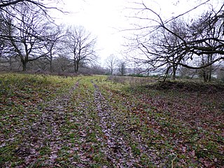
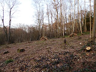
Nemo Down is a 21-hectare (50-acre) [1] nature reserve on the western outskirts of Dover in Kent. It was shown as owned and managed by the Kent Wildlife Trust until 2018. [2]

Dover town and major ferry port in Kent, South East England

Dover is a major ferry port in Kent, South East England. It faces France across the Strait of Dover, the narrowest part of the English Channel, and lies south-east of Canterbury and east of Maidstone. The town is the administrative centre of the Dover District and home of the Dover Calais ferry through the Port of Dover. The surrounding chalk cliffs are known as the White Cliffs of Dover.

Kent County of England

Kent is a county in South East England and one of the home counties. It borders Greater London to the north-west, Surrey to the west and East Sussex to the south-west. The county also shares borders with Essex along the estuary of the River Thames, and with the French department of Pas-de-Calais through the Channel Tunnel. The county town is Maidstone.

Kent Wildlife Trust organization

Kent Wildlife Trust (KWT) is a conservation charity in the United Kingdom that was founded in 1958, previously known as the Kent Trust for Nature Conservation. It aims to "work with people to restore, save and improve our natural spaces" and to "ensure that 30% of Kent and Medway - land and sea - is managed to create a healthy place for wildlife to flourish". In 2016 it had thirty-one thousand members and an annual income of £4 million. KWT manages fifty-four nature reserves, of which twenty-four are Sites of Special Scientific Interest, two are National Nature Reserves, nine are Nature Conservation Review sites, seven are Special Areas of Conservation, three are Special Protection Areas, seven are Local Nature Reserves, one is a Geological Conservation Review site, thirteen are in Areas of Outstanding Natural Beauty and one is a Scheduled Monument.

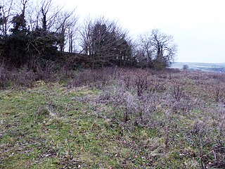
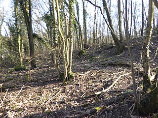
This site has chalk grassland, scrub and woodland. There is a diverse range of plants including pyramidal orchids and wood anemones, and butterflies such as the marbled white and wall brown. [2]

<i>Anemone nemorosa</i> species of plant

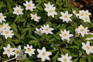
Anemone nemorosa is an early-spring flowering plant in the buttercup family Ranunculaceae, native to Europe. Common names include wood anemone, windflower, thimbleweed, and smell fox, an allusion to the musky smell of the leaves. It is a herbaceous perennial plant growing 5–15 centimetres (2–6 in) tall.

<i>Melanargia galathea</i> species of insect

Melanargia galathea, the marbled white, is a butterfly in the family Nymphalidae.

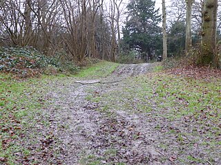
There is access, which can be very muddy, on Coombe Road.

Related Research Articles

East Blean Woods

East Blean Woods is a 151.4-hectare (374-acre) biological Site of Special Scientific Interest south of Herne Bay in Kent. It is also a National Nature Reserve a Special Area of Conservation and a Nature Conservation Review site. An area of 122 hectares is managed by the Kent Wildlife Trust.

Westfield Wood

Westfield Wood is a 5-hectare (12-acre) nature reserve north of Maidstone in Kent, which is managed by the Kent Wildlife Trust. It is part of the Wouldham to Detling Escarpment Site of Special Scientific Interest and Nature Conservation Review site, Grade I.. It is also in the North Downs Woodlands Special Area of Conservation and the Kent Downs Area of Outstanding Natural Beauty.

Burham Down human settlement in United Kingdom

Burham Down is a 110-hectare (270-acre) nature reserve between Maidstone and Chatham in Kent. It is managed by the Kent Wildlife Trust. It is part of the Wouldham to Detling Escarpment Site of Special Scientific Interest and Nature Conservation Review site, Grade I, the Kent Downs Area of Outstanding Natural Beauty, and the North Downs Woodlands Special Area of Conservation.

Lydden and Temple Ewell Downs

Lydden and Temple Ewell Downs is a 63.2-hectare (156-acre) biological Site of Special Scientific Interest north-west of Dover in Kent. It is a Special Area of Conservation and Nature Conservation Review site. It is also part of the 78.5-hectare (194-acre) Lydden Temple Ewell National Nature Reserve and the 90-hectare (220-acre) Lydden Temple Ewell nature reserve, which is managed by the Kent Wildlife Trust. It is in the South Downs Area of Outstanding Natural Beauty.

Broadham Down

Broadham Down is a 16-hectare (40-acre) nature reserve east of Chilham and west of Canterbury in Kent. It is managed by the Kent Wildlife Trust.

Nashenden Down

Nashenden Down is a 55-hectare (140-acre) nature reserve on the southern outskirts of Rochester in Kent. It is managed by the Kent Wildlife Trust, and is in the Kent Downs Area of Outstanding Natural Beauty.

Kemsing Down

Kemsing Down is a 16-hectare (40-acre) nature reserve north of Sevenoaks in Kent. It is managed by the Kent Wildlife Trust. It is in the Kent Downs Area of Outstanding Natural Beauty.

Sladden Wood

Sladden Wood is a 7-hectare (17-acre) nature reserve north of Alkham in Kent. It is managed by the Kent Wildlife Trust.

Old Park Hill

Old Park Hill is a 40-hectare (100-acre) nature reserve north of Dover in Kent. It is managed by the Kent Wildlife Trust (KWT). It is in the Kent Downs Area of Outstanding Natural Beauty.

Fackenden Down

Fackenden Down is a 14-hectare (35-acre) nature reserve north of Sevenoaks in Kent. It is managed by the Kent Wildlife Trust. It is part of the Kent Downs Area of Outstanding Natural Beauty and the Otford to Shoreham Downs Site of Special Scientific Interest

Spuckles and Kennelling Woods

Spuckles and Kennelling Woods is a 20-hectare (49-acre) nature reserve north of Charing in Kent. It is managed by Kent Wildlife Trust. It is in the Kent Downs Area of Outstanding Natural Beauty.

Otford to Shoreham Downs

Otford to Shoreham Downs is a 145.1-hectare (359-acre) biological Site of Special Scientific Interest between Kemsing and Eynesford in Kent. It is part of Kent Downs Area of Outstanding Natural Beauty and part it is Fackenden Down, a nature reserve managed by the Kent Wildlife Trust

Spong Wood

Spong Wood is a 18-hectare (44-acre) nature reserve west of Stelling Minnis in Kent. It is managed by Kent Wildlife Trust.

Wattle Wood

Wattle Wood is a 1-hectare (2.5-acre) nature reserve north-west of Tenterden in Kent. It is managed by Kent Wildlife Trust.

Wouldham to Detling Escarpment

Wouldham to Detling Escarpment is a 311.2-hectare (769-acre) biological and geological Site of Special Scientific Interest which stretches from Wouldham to Detling, north of Maidstone in Kent. Part of it is a Geological Conservation Review site, and it is part of the North Downs Woodlands Special Area of Conservation and the Kent Downs Area of Outstanding Natural Beauty. It is a Nature Conservation Review site, Grade I and it includes three Kent Wildlife Trust nature reserves and a Local Nature Reserve,

Darland Banks

Darland Banks is a 29.1-hectare (72-acre) Local Nature Reserve on the southern outskirts of Gillingham in Kent. It is owned by Medway Council and managed by Kent Wildlife Trust.

Polhill Bank

Polhill Bank is a 4-hectare (9.9-acre) nature reserve south of Shoreham, which is north of Sevenoaks in Kent. It is managed by Kent Wildlife Trust. It is in Kent Downs Area of Outstanding Natural Beauty.

Marden Meadows

Marden Meadows is a 3.7-hectare (9.1-acre) biological Site of Special Scientific Interest east of Marden in Kent. Part of the site is in the 5.6-hectare (14-acre) Marden Meadow nature reserve, which is owned and managed by Kent Wildlife Trust.

Brenchley Wood

Brenchley Wood is a 15-hectare (37-acre) nature reserve south of Paddock Wood in Kent. It is managed by the Kent Wildlife Trust, and it is part of the High Weald Area of Outstanding Natural Beauty.

Bough Beech Reservoir

Bough Beech Reservoir is a 42-hectare (100-acre) nature reserve in Bough Beech, south-west of Sevenoaks in Kent. It is managed by the Kent Wildlife Trust. It is in the Kent Downs Area of Outstanding Natural Beauty.

References

  1. 1 2 Kent Wildlife Trust gives an area of 62 hectares for Nemo Down and the neighbouring High Meadow and Whinless Down, which have total area of 41 hectares, leaving 21 hectares for Nemo Down.
  2. 1 2 "Nemo Down". Kent Wildlife Trust. Archived from the original on 2018-01-03. Retrieved 29 January 2018.

Coordinates: 51°07′48″N1°16′34″E / 51.13°N 1.276°E / 51.13; 1.276

Geographic coordinate system Coordinate system

A geographic coordinate system is a coordinate system that enables every location on Earth to be specified by a set of numbers, letters or symbols. The coordinates are often chosen such that one of the numbers represents a vertical position and two or three of the numbers represent a horizontal position; alternatively, a geographic position may be expressed in a combined three-dimensional Cartesian vector. A common choice of coordinates is latitude, longitude and elevation. To specify a location on a plane requires a map projection.