
Iceland is a Nordic island country between the North Atlantic and Arctic Oceans, on the Mid-Atlantic Ridge between North America and Europe. It is culturally and politically linked with Europe and is the region's westernmost and most sparsely populated country. Its capital and largest city is Reykjavík, which is home to about 36% of the country's roughly 380,000 residents. The official language of the country is Icelandic. Iceland is on a rift between tectonic plates, and its geologic activity includes geysers and frequent volcanic eruptions. The interior consists of a volcanic plateau with sand and lava fields, mountains and glaciers, and many glacial rivers flow to the sea through the lowlands. Iceland is warmed by the Gulf Stream and has a temperate climate, despite a latitude just south of the Arctic Circle. Its latitude and marine influence keep summers chilly, and most of its islands have a polar climate.

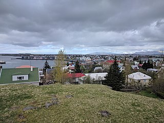
Reykjavík is the capital of, and largest city in, Iceland. It is located in southwestern Iceland, on the southern shore of Faxaflói Bay. With a latitude of 64°08′ N, the city is the world's northernmost capital of a sovereign state. Reykjavík has a population of around 140,000 as of 2023. The Capital Region has a population of around 248,000.

Nuuk is the capital of and most populous city in Greenland, an autonomous territory in the Kingdom of Denmark. Nuuk is the seat of government and the territory's largest cultural and economic center. Nuuk is also the seat of government for the Sermersooq municipality. In January 2024, it had a population of 19,872, – more than a third of the territory's population – making it one of the smallest capital cities in the world by population. Nuuk is considered a modernized city.

The Arctic Archipelago, also known as the Canadian Arctic Archipelago, is an archipelago lying to the north of the Canadian continental mainland, excluding Greenland and Iceland

Akureyri is a town in northern Iceland, the country's fifth most populous municipality and the largest outside the Capital Region. The municipality includes the town's neighbourhood at the head of Eyjafjörður and two farther islands: Hrísey at the mouth of Eyjafjörður and Grímsey off the coast.

The Mid-Atlantic Ridge is a mid-ocean ridge located along the floor of the Atlantic Ocean, and part of the longest mountain range in the world. In the North Atlantic, the ridge separates the North American from the Eurasian plate and the African plate, north and south of the Azores triple junction. In the South Atlantic, it separates the African and South American plates. The ridge extends from a junction with the Gakkel Ridge northeast of Greenland southward to the Bouvet triple junction in the South Atlantic. Although the Mid-Atlantic Ridge is mostly an underwater feature, portions of it have enough elevation to extend above sea level, for example in Iceland. The ridge has an average spreading rate of about 2.5 centimetres (1 in) per year.

The University of Greenland is Greenland's only university. It is in the capital city of Nuuk. Most courses are taught in Danish, a few in Greenlandic and classes by exchange lecturers often in English.
Hafnarfjörður, officially Hafnarfjarðarkaupstaður, is a port town and municipality in Iceland, located about 10 km (6 mi) south of Reykjavík. The municipality consists of two non-contiguous areas in the Capital Region, on the southwest coast of the country. At about 30,000 inhabitants, Hafnarfjörður is the third-most populous city in Iceland after Reykjavík and Kópavogur. It has established local industry and a variety of urban activities, with annual festival events.

Skálholt is a historical site in the south of Iceland, at the river Hvítá.

Borgarnes is a town located on a peninsula at the shore of Borgarfjörður in Iceland and is the largest town in the Borgarbyggð municipality with a population of about 3800 residents. It is a main junction in Iceland and the gateway to the Snaefellsnes National Park. Iceland's capital Reykjavík is 69 kilometers from the center of Borgarnes. The second largest bridge in Iceland, the Borgarfjarðarbrú, connects traffic to and from Reykjavík.

Mosfellsbær is a town in south-west Iceland, 12 kilometres east of the country's capital, Reykjavík. The coat of arms of the municipality is a tightly-knotted triquetra, a symbol often used in Celtic knotwork and strongly associated with the Celtic nations. The coat of arms might denote the Gaelic heritage of Mosfellsbær as Icelanders are also descended from Gaelic-speaking settlers who voyaged or were brought by the Norsemen in Iceland during the country's settlement in the Viking Age.

Álftanes is the name of a town and a collection of small peninsulas in Iceland. It means swan peninsula.

Huldufólk or hidden people are elves in Icelandic and Faroese folklore. They are supernatural beings that live in nature. They look and behave similarly to humans, but live in a parallel world. They can make themselves visible at will. Konrad von Maurer cites a 19th-century Icelandic source claiming that the only visible difference between normal people and outwardly human-appearing huldufólk is, the latter have a convex rather than concave philtrum below their noses.

Suðurnesjabær is a municipality on the northwest tip of Iceland's Southern Peninsula. It includes the towns of Sandgerði and Garður, and was created on 10 June 2018 from a merger of those two municipalities, with the name chosen by its residents the following November. It is the location of Keflavík International Airport, the country's largest airport, and it is adjacent to the town of Keflavík, in the municipality of Reykjanesbær.

Fljótsdalur is a valley in east Iceland, formed by the Lagarfljót River. Lake Lagarfljót and the city of Egilsstaðir are north of the valley.

Breiðholt is a southeastern district of Reykjavík, Iceland. It includes three neighbourhoods: Neðra-Breiðholt, Efra-Breiðholt and Seljahverfi. It is one of the largest districts in Reykjavík, with a population of around 20,000.
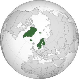
The Nordic countries are a geographical and cultural region in Northern Europe and the North Atlantic. It includes the sovereign states of Denmark, Finland, Iceland, Norway and Sweden; the autonomous territories of the Faroe Islands and Greenland; and the autonomous region of Åland.

Fáskrúðsfjörður is a village (þorp) in eastern Iceland.

Íþróttafélagið Grótta is an Icelandic sports club based in the town of Seltjarnarnes, in the Capital Region. The club is best known for its women's handball team that won the national championship in 2015 and 2016, but also has departments for gymnastics, football and powerlifting.
Hvanneyri is a small settlement in the municipality of Borgarbyggð in western Iceland. The settlement is an agricultural and church center known for its history of farming. Hvanneyri can be found 80 km north of Reykjavík. Hvanneyri is also home to the Agricultural University of Iceland. It has an estimated population of 250 inhabitants.
