The Willandra Lakes Region is a World Heritage Site in the Far West region of New South Wales, Australia. The Willandra Lakes Region is the traditional meeting place of the Muthi Muthi, Ngiyampaa and Barkinji Aboriginal tribes. The 240,000-hectare (590,000-acre) area was inscribed on the World Heritage List at the 5th Session of the World Heritage Committee in 1981.

The Cronulla sand dunes, also known officially as the Cronulla Sand Dune and Wanda Beach Coastal Landscape, are an open space, heritage-listed nature conservation, and visitor attraction located south of Sydney on the Kurnell Peninsula at Lindum Road, Kurnell, New South Wales. Formerly, it was a site for sand mining, film making, and had use as pastoral property. It is also known as part of Kurnell Peninsula Headland and Cronulla Sand Hill. It was added to the New South Wales State Heritage Register on 26 September 2003.

The Malabar Headland is a heritage-listed former public recreation area and military installation site and now nature conservation and public recreation headland area located at Franklin Street, Malabar in the City of Randwick local government area of New South Wales, Australia. It is also known as Long Bay Rifle Range, Anzac Rifle Range and Boora Point. The property is owned by the New South Wales Government. It was added to the New South Wales State Heritage Register on 22 July 2005.

The New South Wales State Heritage Register, also known as NSW State Heritage Register, is a heritage list of places in the state of New South Wales, Australia, that are protected by New South Wales legislation, generally covered by the Heritage Act 1977 and its 2010 amendments. The register is administered by the Heritage Council of NSW via Heritage NSW, a division of the Government of New South Wales Department of Planning and Environment.

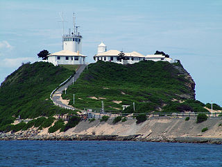
Cape Byron Light, also called Cape Byron Lightstation, is an active heritage-listed lighthouse and now interpretative centre, interpretative space, maritime museum, administration office, retail building, accommodation, tourist attraction and visitor attraction located at Cape Byron on the Far North Coast of New South Wales, Australia. It was designed by Charles Harding and Cecil W. Darley and built from 1899 to 1901 by Messrs Mitchell & King. It is also known as Cape Byron Lightstation, Byron Bay Lighthouse, Cape Byron Headland and Cape Byron Headland Reserve. The property is owned by NSW National Parks & Wildlife Service.

Wapengo is a locality in the Bega Valley Shire of New South Wales, Australia. At the 2016 census, Wapengo had a population of 69.

Baronda is a heritage-listed former holiday house in the Mimosa Rocks National Park on the South Coast of New South Wales, Australia. Located on Nelson Lake Road at Nelson Lagoon near the village of Tanja, it was designed by Graeme Gunn and built from 1968 to 1969 by Kingsley Koellner (builder) and Hamish Ramsay. It is also known as Yencken House, Baronda Holiday House and Graeme Gunn-designed house. The property is owned by the NSW National Parks and Wildlife Service and the NSW Office of Environment and Heritage. It was added to the New South Wales State Heritage Register on 29 November 2013.

Oaklands is a heritage-listed homestead at Princes Highway, Pambula, Bega Valley Shire, New South Wales, Australia. It was built from 1842 by Messrs Robertson, Hall and Rogers. It was also known as Pamboola Station. It was added to the New South Wales State Heritage Register on 20 February 2004.

Currango Homestead is a heritage-listed farm and homestead at Tantangara in the Kosciuszko National Park in New South Wales, Australia. The property is owned by the Office of Environment and Heritage. It was added to the New South Wales State Heritage Register on 2 April 1999.
Coal River Precinct is a heritage-listed historic precinct at Nobbys Road, Newcastle, New South Wales, Australia. It was built from 1804 to 1960. It includes Fort Scratchley, Nobbys Head, the Convict Lumber Yard site, Macquarie Pier, the breakwater and Nobby's Beach. It was added to the New South Wales State Heritage Register on 19 December 2003.

The Cattai Estate is a heritage-listed former farm and cultural landscape and now national park at Wisemans Ferry Road, Cattai, New South Wales, an outer suburb of Sydney, Australia. It was built from 1804 to 1821. It is also known as Caddai Estate, Cattai National Park and Caddie estate. The property is owned by Office of Environment and Heritage, an agency of the Government of New South Wales. It was added to the New South Wales State Heritage Register on 2 April 1999.

Bass Point Reserve is a heritage-listed former cedar timber industry, Aboriginal camping, meeting place, pastoral property and basalt mine and now nature conservation and passive recreation area located at Boollwarroo Parade, Shell Cove in the Illawarra region of New South Wales, Australia. It is also known as Long Point. The property is owned by Department of the Environment and Shellharbour City Council. It was added to the New South Wales State Heritage Register on 18 January 2013.
Royal National Park Coastal Cabin Communities are heritage-listed cabin communities in the Royal National Park, Lilyvale, City of Wollongong, New South Wales, Australia. They were built from 1930 to 1950 by private citizens using their own initiative, resources and labour. It refers to the specific communities of Little Garie, Era and Burning Palms, also known collectively as the Royal National Park Coastal Shack Communities. The area is owned by the Office of Environment and Heritage. It was added to the New South Wales State Heritage Register on 27 April 2012.

The Old Sugarmill is a heritage-listed former sugar mill and now apartments at Sugar House Road, Canterbury in the City of Canterbury-Bankstown local government area of New South Wales, Australia. It was designed by Woodhouse Danks and built from 1839 to 1841. It is also known as Canterbury Sugar Works, Former Hutton Premises, Australian Sugar Company Mill, Canterbury Sugar House, ASC Sugar Mill Buildings and Australasian Sugar Company. It was added to the New South Wales State Heritage Register on 2 April 1999.

The Blue Mountains walking tracks are heritage-listed picnic areas, walking tracks and rest areas located in the Blue Mountains National Park, west of Sydney in New South Wales, Australia. They were built from 1880 onwards. The property is owned by the NSW Office of Environment and Heritage, an agency of the Government of New South Wales. The facilities were added to the New South Wales State Heritage Register on 2 April 1999.
The Coxs River track is a heritage-listed former walking track and road and now walking track at Cox's River Arms, Lake Burragorang/Warragamba Dam, City of Blue Mountains, New South Wales, Australia. The track is also known as the Warragamba Dam - Burragorang Valley - Wentworth Falls Track. The property is owned by the Sydney Catchment Authority, an agency of the Government of New South Wales. It was added to the New South Wales State Heritage Register on 18 November 1999.

Playfair's Terrace are heritage-listed terrace houses located at 1–7 Atherden Street in the inner-city Sydney suburb of The Rocks in the City of Sydney local government area of New South Wales, Australia. It was built in 1880. It is also known as Playfairs. The property is owned by Property NSW, an agency of the Government of New South Wales. It was added to the New South Wales State Heritage Register on 10 May 2002.
67 Harrington Street, The Rocks is a heritage-listed serviced apartments complex and former terrace house located at 67 Harrington Street, in the inner city Sydney suburb of The Rocks in the City of Sydney local government area of New South Wales, Australia. It was built from 1885. It is also known as Stafford Apartments and 75 Harrington Street; Clocktower Development. The property is owned by Property NSW, an agency of the Government of New South Wales. It was added to the New South Wales State Heritage Register on 10 May 2002.

32–36 and 38–40 Gloucester Street facades, The Rocks is a heritage-listed former residence located at 32-36 and 38-40 Gloucester Street, in the inner city Sydney suburb of The Rocks in the City of Sydney local government area of New South Wales, Australia. It was built during 1885. It is also known as part of development known as 40 Gloucester Street. The property is owned by Property NSW, an agency of the Government of New South Wales. It was added to the New South Wales State Heritage Register on 10 May 2002.

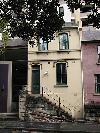
Alfred's Terrace is a heritage-listed row of terrace houses located at 37–47 Kent Street, in the inner city Sydney suburb of Millers Point in the City of Sydney local government area of New South Wales, Australia. The property was added to the New South Wales State Heritage Register on 2 April 1999.


