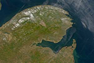
Chaleur Bay, also Chaleurs Bay, Bay of Chaleur, is an arm of the Gulf of Saint Lawrence located between Quebec and New Brunswick, Canada.

Bathurst is a city in northern New Brunswick with a population of 12,157 and the 4th largest metropolitan area in New Brunswick as defined by Census Canada with a population of 31,387 as of 2021. The City of Bathurst overlooks Nepisiguit Bay, part of Chaleur Bay and is at the estuary of the Nepisiguit River.

Campbellton is a city in Restigouche County, New Brunswick, Canada.
Beresford is a community in the town of Belle-Baie in Gloucester County, New Brunswick. It was a town from 1984 to 2023, when it was amalgamated with surrounding municipalities to form the town of Belle-Baie.

Beresford is a geographic parish in Gloucester County, New Brunswick, Canada.

Petit-Rocher is a former village in Gloucester County, New Brunswick. It held village status prior to 2023 and is now part of the town of Belle-Baie. Sitting on the western shore of both Chaleur Bay and Nepisiguit Bay 20 km northwest of Bathurst.

Nigadoo is a community in the town of Belle-Baie in Gloucester County, New Brunswick. It was a village prior to 2023, when it was amalgamated with surrounding municipalities to form the town of Belle-Baie. Nigadoo is located at the mouth of the Nigadoo River on Nepisiguit Bay, 15 km northwest of Bathurst and adjacent to Beresford.
Pointe-Verte is a community in the town of Belle-Baie in Gloucester County, New Brunswick. It was a village from 1966 to 2023, when it was amalgamated with surrounding municipalities to form the town of Belle-Baie.

The Nepisiguit River is a major river in northern New Brunswick, Canada, which enters the sea at the city of Bathurst, into the Nepisiguit Bay, part of the Bay of Chaleur.

Anse-Bleue is a community in the Canadian province of New Brunswick. The small community is located in New Bandon Parish in Gloucester County, northern New Brunswick, on the southern shore of Chaleur Bay. Most of the population is of Acadian descent and is located along the beach.
Janeville is a community in Gloucester County, New Brunswick on the Chaleur Bay. The Community is located at the Intersection of Route 11 and Route 340. It straddles the boundary between Bathurst and New Bandon Parishes and is part of the local service district of New Bandon-Salmon Beach.
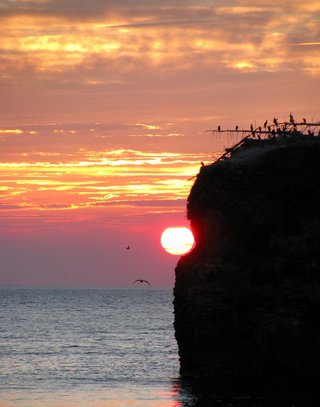
Pokeshaw is an unincorporated village in Gloucester County, New Brunswick, Canada. It houses a former provincial, now communal park that includes a beach, and a large rock stack, Pokeshaw Island, also known as Pokeshaw Rock, which serves as a nesting ground for hundreds of seabirds who can be seen on the top.

Stonehaven is a Canadian rural community in Gloucester County, New Brunswick, in the parish of New Bandon. Situated about 30 kilometres (19 mi) east of Bathurst on Route 11, Stonehaven is on the southern shore of the Baie des Chaleurs.
Point de Maisonnette is a cape located in northeastern New Brunswick, Canada. Its geographic coordinates are 47º50'15"N, 65º00'13"W.

Colborne is a geographic parish in Restigouche County, New Brunswick, Canada.

Bathurst is a geographic parish in Gloucester County, New Brunswick, Canada.

New Bandon is a geographic parish in Gloucester County, New Brunswick, Canada.

Paquetville is a geographic parish in Gloucester County, New Brunswick, Canada.

Allardville is a geographic parish in Gloucester County, New Brunswick, Canada,

Nepisiguit Bay is located in northern New Brunswick, Canada on the southern part of the Chaleur Bay, which extends from the Atlantic Ocean and Nepisiguit Bay is a southern arm of it, stretching between Petit-Rocher and Stonehaven.

