
Castleford is a town in the metropolitan borough of Wakefield, West Yorkshire, England. It had a population of 40,210 at the 2011 Census. Historically in the West Riding of Yorkshire, to the north of the town centre the River Calder joins the River Aire and the Aire and Calder Navigation.

Nostell is a village in the City of Wakefield in West Yorkshire, England, near Hemsworth. It is in the civil parish of Huntwick with Foulby and Nostell, which had a population of 90 in 2001, and 164 at the 2011 census. and is the site of an Augustinian priory which received its charter in 1121.

Airedale is a geographic area in Yorkshire, England, corresponding to the river valley or dale of the River Aire.

The City of Wakefield is a local government district in West Yorkshire, England, with the status of a city and metropolitan borough. Wakefield is the district's administrative centre. The population of the City of Wakefield at the 2011 Census was 325,837. The district includes the ‘Five Towns’ of Normanton, Pontefract, Featherstone, Castleford and Knottingley. Other towns include Ossett, Hemsworth, South Kirkby and Moorthorpe and South Elmsall. The City and borough are governed by Wakefield Metropolitan District Council. Wakefield lies between Leeds and Barnsley

Featherstone is a town and civil parish in the City of Wakefield in West Yorkshire, England, two miles south-west of Pontefract. Historically part of the West Riding of Yorkshire, in 2011, it had a population of 15,244. Featherstone railway station is on the Pontefract Line.

Pontefract and Castleford was a constituency represented in the House of Commons of the Parliament of the United Kingdom until the 2010 general election. It elected one Member of Parliament (MP) by the first past the post system of election.

Allerton Bywater is a semi-rural village and civil parish in the south-east of the City of Leeds metropolitan borough in West Yorkshire, England. The population of the civil parish as of the 2011 census was 4,717. The village itself is 2 miles (3.2 km) north of Castleford, with neighbouring villages Kippax and Great Preston all providing local amenities. St Aidan’s Nature reserve borders the village attracting many visitors with its beauty and charm. Additionally ‘The Lines’ bridal path which runs from Garforth through to Allerton following the old train track provides a pleasant route for walkers, joggers and cyclists alike. The River Aire flows through the village to the south-west.
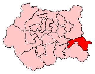
Normanton, Pontefract and Castleford is a constituency represented in the House of Commons of the UK Parliament by Yvette Cooper of the Labour Party since its 2010 creation.
Silverwood Colliery was a colliery situated between Thrybergh and Ravenfield in Yorkshire, England. Originally called Dalton Main, it was renamed after a local woodland. It was owned by Dalton Main Collieries Ltd.

Orgreave Colliery was a coal mine situated adjacent to the main line of the Manchester, Sheffield and Lincolnshire Railway about 5 miles (8 km) east of Sheffield and 3.5 miles (6 km) south west of Rotherham. The colliery is within the parish of Orgreave, from which it takes its name.

The Maltby Main Colliery was a coal mine located 7 miles (11 km) east of Rotherham on the eastern edge of Maltby, South Yorkshire, England. The mine was closed in 2013.

Glasshoughton is a neighbourhood of Castleford in West Yorkshire, England, that borders on Pontefract. The appropriate Wakefield ward is called Castleford Central and Glasshoughton. It is home to the Xscape indoor ski slope and leisure centre, the Junction 32 Outlet Shopping Village, a DIY superstore, a hotel, several pubs and a number of fast food restaurants, which were built on the site of the former Glasshoughton Colliery and coke coking plant. This area also contains the Glasshoughton Wheel of Light, a former pit winding wheel now made into a sculpture as a memorial to the miners of Glasshoughton.

Barnburgh Main Colliery was a coal mine situated on the outskirts of the village of Barnburgh, about two miles north of Mexborough in the Dearne Valley, South Yorkshire, England. The sinking of the colliery was commenced in 1911 by the Manvers Main Colliery Company of Wath-upon-Dearne.

Ferry Fryston is a suburb of the town of Castleford in West Yorkshire, England. It is situated in the metropolitan borough of the City of Wakefield. The appropriate ward is called Airedale and Ferry Fryston.

Airedale is a suburb in the town of Castleford, West Yorkshire, England. It consists mainly of Local Authority Housing. It borders with Ferry Fryston. The ward of the City of Wakefield called Airedale and Ferry Fryston had a population of 14,811 at the 2011 Census. The River Aire runs in close proximity to Airedale and is thought to get its name from there. Yvette Copper MP is also from Airedale.
Frickley & South Elmsall Colliery was opened by the Carlton Main Colliery Company Ltd in 1903 in South Elmsall, in Yorkshire, England.

Selby coalfield was a large-scale deep underground mine complex based around Selby, North Yorkshire, England, with pitheads at Wistow Mine, Stillingfleet Mine, Riccall Mine, North Selby Mine, Whitemoor Mine and at Gascoigne Wood Mine; all coal was brought to the surface and treated at Gascoigne Wood, being distributed onwards by rail. The primary purpose of the pit was to supply coal for electrical power generation; much of it was used in the nearby Aire valley power stations.

Wheldale Colliery was a coal mine located in Castleford, Yorkshire, England which produced coal for 117 years. It was accessed from Wheldon Road.

Fryston Hall was a country house at Water Fryston, West Yorkshire which stood in an estate between the town of Castleford and the River Aire near where the river is crossed by the A1(M). The main building was demolished in 1934 and only some outbuildings survive as farm buildings.

The Burnley Coalfield is the most northerly portion of the Lancashire Coalfield. Surrounding Burnley, Nelson, Blackburn and Accrington, it is separated from the larger southern part by an area of Millstone Grit that forms the Rossendale anticline. Occupying a syncline, it stretches from Blackburn past Colne to the Yorkshire border where its eastern flank is the Pennine anticline.

