
Interstate 97 (I-97) is a north-south Interstate Highway in the eastern United States. It runs entirely within Anne Arundel County, Maryland, for 17.62 miles (28.36 km) from U.S. Route 50/U.S. Route 301 (US 50/US 301) in Parole near Annapolis north to I-695 and I-895B in Brooklyn Park near Baltimore. The interstate is the primary highway between Baltimore and Annapolis. I‑97 connects Annapolis with Baltimore/Washington International Airport and links the northern Anne Arundel County communities of Crownsville, Millersville, Severna Park, Glen Burnie, and Ferndale. It is currently the second shortest primary Interstate Highway in the country after the unfinished I-87 in North Carolina.

The New Jersey Turnpike (NJTP) is a system of controlled-access highways in the U.S. state of New Jersey. The turnpike is maintained by the New Jersey Turnpike Authority. The 117.2-mile (188.6 km) mainline's southern terminus is at the Delaware Memorial Bridge on I-295 in Pennsville. Its northern terminus is at an interchange with I-80 and US 46 in Ridgefield Park. Construction of the mainline, from concept to completion, took a total of 22 months between 1950 and 1951. It was opened to traffic on November 5, 1951, between its southern terminus and exit 10.

The Garden State Parkway (GSP) is a controlled-access, tolled highway that stretches the north–south length of eastern New Jersey from the state's southernmost tip near Cape May north to the New York state line at Montvale. Its name refers to New Jersey's nickname, the "Garden State". The parkway has an unsigned reference number of Route 444 by the New Jersey Department of Transportation (NJDOT). At its north end, the road becomes the Garden State Parkway Connector, a component of the New York State Thruway system that connects to the Thruway mainline in Ramapo.

Route 34 is a primary state highway in the U.S. state of Connecticut. Route 34 is 24.37 miles (39.22 km) long, and extends from Washington Avenue near I-84/US 6 in Newtown to the junction of I-91 and I-95 in New Haven. The highways connects the New Haven and Danbury areas via the Lower Naugatuck River Valley. The portion of the route between New Haven and Derby was an early toll road known as the Derby Turnpike.

Interstate 695 (I-695) is a 51.46-mile-long (82.82 km) auxiliary Interstate Highway that constitutes a beltway extending around Baltimore, Maryland, United States. I-695 is officially designated the McKeldin Beltway but is colloquially referred to as either the Baltimore Beltway or 695. The route is an auxiliary route of I-95, intersecting that route southwest of Baltimore near Arbutus and northeast of the city near White Marsh. It also intersects other major roads radiating from the Baltimore area, including I-97 near Glen Burnie, the Baltimore–Washington Parkway near Linthicum, I-70 near Woodlawn, I-795 near Pikesville, and I-83 in the Timonium area. The 19.37-mile (31.17 km) portion of the Baltimore Beltway between I-95 northeast of Baltimore and I-97 south of Baltimore is officially Maryland Route 695 (MD 695) and is not part of the Interstate Highway System but is signed as I-695. The Francis Scott Key Bridge that crossed over the Patapsco River was included in this section of the route before the bridge's collapse on March 26, 2024. The bridge and its approaches were maintained by the Maryland Transportation Authority (MDTA), while the remainder of the Baltimore Beltway is maintained by the Maryland State Highway Administration (MDSHA).

Interstate 295 (I-295) in Delaware, New Jersey, and Pennsylvania is an auxiliary Interstate Highway, designated as a bypass around Philadelphia, and a partial beltway of Trenton.

Interstate 275 (I-275), located in Florida, is a 60-mile-long (97 km) auxiliary Interstate Highway serving the Tampa Bay area. Its southern terminus is at I-75 near Palmetto, where I-275 heads west towards the Sunshine Skyway Bridge crossing over Tampa Bay. From that point, I-275 passes through St. Petersburg before crossing Tampa Bay again on the Howard Frankland Bridge, then continues through the city of Tampa, where it connects to an interchange with I-4 in Downtown Tampa. After the interchange, I-275 passes north through the Tampa suburbs to its northern terminus at I-75 in Wesley Chapel.
The Connecticut Turnpike is a freeway and former toll road in the U.S. state of Connecticut; it is maintained by the Connecticut Department of Transportation (ConnDOT). Spanning approximately 128 miles (206 km) along a generally west–east axis, its roadbed is shared with Interstate 95 (I-95) for 88 miles (142 km) from the New York state border in Greenwich to East Lyme; I-395 for 36 miles (58 km) from East Lyme to Plainfield; and SR 695 for four miles (6.4 km) from Plainfield to the Rhode Island state line at U.S. Route 6 (US 6) in Killingly. The turnpike briefly runs concurrently with US 1 from Old Saybrook to Old Lyme and Route 2A from Montville to Norwich.

The Springfield Interchange, also known as the Mixing Bowl, is the interchange of Interstate 95, Interstate 395, and Interstate 495 in Springfield, Virginia, outside of Washington, D.C. The interchange is located at exit 57 on the Capital Beltway, exit 170 on I-95, and exit 1 on I-395.

Interstate 95 (I-95) is the main north–south Interstate Highway on the East Coast of the United States, running in a general east–west compass direction for 111.57 miles (179.55 km) in Connecticut, from the New York state line to the Rhode Island state line. I-95 from Greenwich to East Lyme is part of the Connecticut Turnpike, during which it passes through the major cities of Stamford, Bridgeport, and New Haven. After leaving the turnpike in East Lyme, I-95 is known as the Jewish War Veterans Memorial Highway and passes through New London, Groton, and Mystic, before exiting the state through North Stonington at the Rhode Island border.
The Raymond E. Baldwin Bridge is a concrete segmental bridge composed of eleven spans crossing the Connecticut River between Old Saybrook, Connecticut and Old Lyme, Connecticut. The bridge carries Interstate 95 and U.S. Route 1, with an average daily traffic of 82,500 vehicles.
Interstate 95 (I-95) is an Interstate Highway running along the East Coast of the United States from Miami, Florida, north to the Canadian border at Houlton, Maine. In Maryland, the route is a major highway that runs 110.01 miles (177.04 km) diagonally from southwest to northeast, entering from the District of Columbia and Virginia at the Woodrow Wilson Bridge over the Potomac River, northeast to the Delaware state line near Elkton. It is the longest Interstate Highway within Maryland and is one of the most traveled Interstate Highways in the state, especially between Baltimore and Washington, D.C., despite alternate routes along the corridor, such as the Baltimore–Washington Parkway, U.S. Route 1 (US 1), and US 29. I-95 also has eight auxiliary routes in the state, the most of any state along the I-95 corridor. Portions of the highway, including the Fort McHenry Tunnel and the Millard E. Tydings Memorial Bridge, are tolled.
Interstate 95 (I-95) is a part of the Interstate Highway System that parallels the East Coast of the United States from Miami, Florida, in the south to Houlton, Maine, in the north. In the US state of Massachusetts, it spans 92 miles (148 km) along a north–south axis. It is the third-longest Interstate Highway in Massachusetts, behind I-90 and I-495, while I-95 in full is the longest north–south Interstate and sixth-longest Interstate Highway in the US.
Interstate 95 (I-95) is an Interstate Highway running along the East Coast of the United States from Miami, Florida, north to the Canadian border in Houlton, Maine. In the state of Delaware, the route runs for 23.43 miles (37.71 km) across the Wilmington area in northern New Castle County from the Maryland state line near Newark northeast to the Pennsylvania state line in Claymont. I-95 is the only primary Interstate Highway that enters Delaware, although it also has two auxiliary routes within the state. Between the Maryland state line and Newport, I-95 follows the Delaware Turnpike, a toll road with a mainline toll plaza near the state line. Near Newport, the Interstate has a large interchange with Delaware Route 141 (DE 141) and the southern termini of I-295 and I-495. I-95 becomes the Wilmington Expressway from here to the Pennsylvania state line and heads north through Wilmington concurrently with U.S. Route 202 (US 202). Past Wilmington, I-95 continues northeast to Claymont, where I-495 rejoins the route right before the Pennsylvania state line.

U.S. Route 9 (US 9) is a United States Numbered Highway in the Mid-Atlantic region of the United States, running from Laurel, Delaware, to Champlain, New York. In New Jersey, the route runs 166.80 miles (268.44 km) from the Cape May–Lewes Ferry terminal in North Cape May, Cape May County, where the ferry carries US 9 across the Delaware Bay to Lewes, Delaware, north to the George Washington Bridge in Fort Lee, Bergen County, where the route along with Interstate 95 (I-95) and US 1 continue into New York City. US 9 is the longest U.S. Highway in the state.
Interstate 95 (I-95) is a major north–south Interstate Highway that runs along the East Coast of the United States from Miami, Florida, north to the Canada–United States border at Houlton, Maine. In the state of Pennsylvania, it runs 51.00 miles (82.08 km) from the Delaware state line near Marcus Hook in Delaware County in the southeastern part of the state northeast to the Delaware River–Turnpike Toll Bridge at the New Jersey state line near Bristol in Bucks County, closely paralleling the New Jersey state line for its entire length through Pennsylvania.

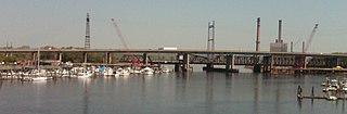
The Pearl Harbor Memorial Bridge, commonly referred to as the Q Bridge by locals, is an extradosed bridge that carries Interstate 95 over the mouth of the Quinnipiac River in New Haven, in the U.S. state of Connecticut. This bridge replaced the original 1,300 m (0.8 mi) span which opened on January 2, 1958. The old bridge had a girder and floorbeam design where steel beams supported a concrete bridge deck that carried three lanes of traffic in each direction with no inside or outside shoulders. The bridge was officially dedicated as the Pearl Harbor Memorial Bridge in 1995 to commemorate the attack on Pearl Harbor.

Interstate 15 (I-15) runs north–south in the U.S. state of Utah through the southwestern and central portions of the state, passing through most of the state's population centers, including St. George and those comprising the Wasatch Front: Provo–Orem, Salt Lake City, and Ogden–Clearfield. It is Utah's primary and only north–south interstate highway, as the vast majority of the state's population lives along its corridor; the Logan metropolitan area is the state's only Metropolitan Statistical Area through which I-15 does not pass. In 1998, the Utah State Legislature designated Utah's entire portion of the road as the Veterans Memorial Highway.
Moses Wheeler Bridge carries Interstate 95 over the Housatonic River between Stratford and the Devon section of Milford. The current bridge is a 14-span continuous girder and floorbeam structure that carries three lanes of traffic in each direction, with full inside and outside shoulders. The current bridge, completed in 2016, replaces a pre-existing structure that was completed as part of the original Connecticut Turnpike in 1958. The original bridge was a 34-span plate girder structure with a concrete deck with three 12-foot travel lanes in each direction and no shoulders. The central span of the original bridge over the river's navigation channel included a pin and hanger assembly, which are no longer used in bridge construction in the United States. Construction on the Moses Wheeler Bridge began in 1955 and opened on January 2, 1958.

U.S. Route 202 is a US Highway running from New Castle, Delaware, northeast to Bangor, Maine. In the U.S. state of Pennsylvania, the route runs for 59 miles (95 km), from the Delaware state line in Bethel Township, Delaware County, to the New Hope–Lambertville Toll Bridge over the Delaware River in Solebury Township, where the route crosses into New Jersey. The highway runs through the western and northern suburbs of Philadelphia in the Delaware Valley metropolitan area, and serves as a toll-free bypass around the city, avoiding the busy traffic and congestion on Interstate 95 (I-95). It is signed north–south and follows a general southwest–northeast direction through the state.