Moses Wheeler Bridge

Last updated
Moses Wheeler Bridge
Coordinates 41°12′17″N73°06′34″W / 41.20472°N 73.10944°W / 41.20472; -73.10944
Carries6 lanes of I-95.svg I-95
Crosses Housatonic River
Locale Stratford, Connecticut/Milford, Connecticut
Official nameMoses Wheeler Bridge
Maintained by Connecticut Department of Transportation [1]
Characteristics
DesignContinuous steel plate girder and floorbeam
Total length967 meters (3,196 feet)
No. of spans14
History
Opened1958 (Reconstructed 2011-2016)
Location
Moses Wheeler Bridge

Moses Wheeler Bridge carries Interstate 95 (Connecticut Turnpike) over the Housatonic River between Stratford and the Devon section of Milford. The current bridge is a 14-span continuous girder and floorbeam structure that carries three (expandable to four) lanes of traffic in each direction, with full inside and outside shoulders. The current bridge, completed in 2016, replaces a pre-existing structure that was completed as part of the original Connecticut Turnpike in 1958. The original bridge was a 34-span plate girder structure with a concrete deck with three 12-foot travel lanes in each direction and no shoulders. The central span of the original bridge over the river's navigation channel included a pin and hanger assembly, which are no longer used in bridge construction in the United States. Construction on the Moses Wheeler Bridge began in 1955 and opened on January 2, 1958.

Contents

The original Moses Wheeler Bridge, as seen from Washington Bridge, in 2010. Cranes can be seen assembling piers and abutments for the new bridge Moses Wheeler Bridge.jpg
The original Moses Wheeler Bridge, as seen from Washington Bridge, in 2010. Cranes can be seen assembling piers and abutments for the new bridge

Replacement Bridge

Heavy traffic and harsh New England weather had taken their toll on the original Moses Wheeler Bridge. It had been rated as 'structurally deficient' during recent inspections, with accelerating deterioration of the structural steel and the fracture critical pin and hanger assemblies being of particular concern; the latter problem gained increased attention due to the collapse of the similar-in-design Mianus River Bridge further west in Greenwich in 1983. The Connecticut Department of Transportation (CONNDOT) began drawing up plans to replace the bridge in 1996. Originally CONNDOT planned to construct the new bridge to the south of the existing one, away from 115 kilovolt high tension wires that run atop the nearby Housatonic River Railroad Bridge. Stratford residents and officials demanded the new bridge be built to the north of the existing span, closer to the Metro-North bridge and the power lines. A compromise was reached where the new bridge will use approximately the same alignment as the original one. To make this possible, the new bridge was built substantially wider than the old one, which will also allow a future expansion with restriping of the travel lanes. The project was completed in three stages: the first two stages consisted of constructing the outer parts of the new bridge that carry the two outer lanes and the outer shoulder, while three lanes of traffic were maintained on the existing bridge. During the final stage of construction, three lanes of traffic were shifted to the new outer spans, to allow crews to demolish the original span and complete the center portion of the new bridge.

The new bridge, like the original one, accommodates six lanes of traffic, but has full left and right shoulders which the original bridge did not have. In addition, the left shoulders were built wide enough to accommodate a future widening to eight lanes. Two design options were developed for the new 14-span structure: one option using segmented concrete hollow box girders, and the other using continuous steel plate girders. The bridge is designed for seismic loading to withstand a major earthquake. Additionally, it includes a fender system to protect the bridge piers from ship collisions. Aesthetic features are also included, among which is encasing the bridge piers with decorative granite and aesthetic lighting. The STV Group designed the replacement bridge. [2]

Environmental studies for the new bridge were completed in 2005, and CONNDOT awarded a $60 million contract to Torrington, Connecticut-based O&G Industries for the initial phase of work in July 2009. Construction on the first phase of replacing the bridge, including the foundations for the new bridge piers and temporary work trusses in the Housatonic River began in September 2009. The $166.5 million contract to build the remainder of the new bridge and demolish the existing span was awarded to a joint venture between Chicago, Illinois-based Walsh Construction Company and Denver, Colorado-based PCL Constructors (also referred to in contract documents as Walsh/PCL Joint Venture II) in August 2011. Walsh/PCL opted to use the steel plate girder design option.

Walsh/PCL commenced work to widen I-95 on the east and west approaches and began erecting the bridge piers for the new Moses Wheeler Bridge in September 2011. Crews shifted I-95 traffic to the southern half of the roadway so the northern half of the highway, including several smaller overpasses could rebuilt and expanded. On January 17, 2013, southbound traffic was shifted onto the completed northern third of the new bridge and approaches. Northbound traffic was shifted onto the former southbound lanes of the old bridge on January 26, 2013. The Walsh/PCL construction team began demolishing the northbound portion of the old bridge and approaches in February 2013. Demolition of the old northbound span was completed in May 2013, and crews began erecting structural steel for the new northbound lanes in June 2013. In December 2013, northbound traffic was shifted from the old bridge to the new northbound lanes, at which point the remainder of the original 1958 structure was taken out of service and removed. During the summer of 2014, three large gantry cranes were assembled in the median of I-95 to facilitate the removal of structural steel from the original span and construction of the center portion of the new span. By the end of 2015, construction of the new Moses Wheeler Bridge reached substantial completion, with final paving and striping completed in spring 2016.

Emergency repairs

During the summer of 2007, CONNDOT performed a $6.9 million emergency repair project to the Moses Wheeler Bridge after several large holes opened up in the bridge deck, [3] and advanced deterioration of the structural steel was discovered during a routine inspection. The project involved a full-depth patch and repair of the bridge deck, roadway resurfacing, and reinforcement of key superstructure components to ensure the bridge could remain in service until the new bridge can be built. [4]

See also

Related Research Articles

<span class="mw-page-title-main">Harvard Bridge</span> Charles River overpass

The Harvard Bridge is a steel haunched girder bridge carrying Massachusetts Avenue over the Charles River and connecting Back Bay, Boston with Cambridge, Massachusetts. It is the longest bridge over the Charles River at 2,164.8 feet.

<span class="mw-page-title-main">14th Street bridges</span> 3 bridges across the Potomac River connecting Arlington, VA and Washington, D.C., USA

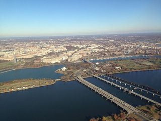
The 14th Street bridges refers to the three bridges near each other that cross the Potomac River, connecting Arlington, Virginia and Washington, D.C. Sometimes the two nearby rail bridges are included as part of the 14th Street bridge complex. A major gateway for automotive, bicycle and rail traffic, the bridge complex is named for 14th Street, which feeds automotive traffic into it on the D.C. end.

<span class="mw-page-title-main">Key Bridge (Washington, D.C.)</span> Bridge in Washington, D.C., and Virginia, U.S.

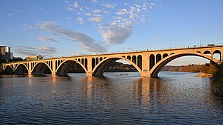
The Francis Scott Key Bridge, more commonly known as the Key Bridge, is a six-lane reinforced concrete arch bridge carrying U.S. Route 29 (US 29) across the Potomac River between the Rosslyn neighborhood of Arlington County, Virginia, and the Georgetown neighborhood of Washington, D.C. Completed in 1923, it is Washington's oldest surviving road bridge across the Potomac River.

<span class="mw-page-title-main">Narrows Bridge (Perth)</span> Set of bridges in Perth, Western Australia

The Narrows Bridge is a freeway and railway crossing of the Swan River in Perth, Western Australia.

<span class="mw-page-title-main">Huey P. Long Bridge (Jefferson Parish)</span> Road and railroad bridge in Louisiana, U.S.

The Huey P. Long Bridge, located in Jefferson Parish, Louisiana, is a cantilevered steel through-truss bridge that carries a two-track railroad line over the Mississippi River at mile 106.1, with three lanes of US 90 on each side of the central tracks. It is several kilometers upriver from the city of New Orleans. The East Bank entrance is at Elmwood, Louisiana, and the West Bank at Bridge City.

<span class="mw-page-title-main">Edison Bridge (New Jersey)</span> Bridge in New Jersey and Sayreville, New Jersey

The Edison Bridge and the Vieser bridge are a pair of bridges that carry U.S. Route 9 in the state of New Jersey, spanning the Raritan River near its mouth in Raritan Bay. The bridge, which connects Woodbridge on the north with Sayreville on the south, was opened to weekend traffic starting on October 11, 1940, and was opened permanently on November 15, 1940. As of 2003, the bridge carries more than 82,000 vehicles daily and is owned and operated by the New Jersey Department of Transportation. It also runs directly parallel to the Driscoll Bridge, which carries the Garden State Parkway.

<span class="mw-page-title-main">Extradosed bridge</span>

An extradosed bridge employs a structure that combines the main elements of both a prestressed box girder bridge and a cable-stayed bridge. The name comes from the word extrados, the exterior or upper curve of an arch, and refers to how the "stay cables" on an extradosed bridge are not considered as such in the design, but are instead treated as external prestressing tendons deviating upward from the deck. In this concept, they remain part of the main bridge superstructure.

<span class="mw-page-title-main">I-90 Mississippi River Bridge</span> Bridge in Minnesota to La Crosse, Wisconsin

The I-90 Mississippi River Bridge, or the Dresbach Bridge, consists of a pair of parallel bridges that traverse the Mississippi River, connecting the La Crosse, Wisconsin area to Dresbach in rural Winona County, Minnesota. The current bridge was fully opened to traffic in October 2016, replacing a previous 1967 plate girder bridge. It is part of the Interstate 90 route. There is another automobile crossing a few miles south of this bridge; the Mississippi River Bridge, a combination of two bridges, and the La Crosse West Channel Bridge, connecting La Crescent, Minnesota and La Crosse, Wisconsin.

<span class="mw-page-title-main">Charter Oak Bridge</span> Bridge in Connecticut and East Hartford, Connecticut

The Charter Oak Bridge is one of the three highway bridges over the Connecticut River between Hartford, Connecticut and East Hartford, Connecticut. The twin steel stringer bridge carries the Wilbur Cross Highway over the river.

<span class="mw-page-title-main">Victoria Bridge, Penrith</span> Bridge in New South Wales, Australia

The Victoria Bridge, also known as the Victoria Bridge over the Nepean River, is a heritage-listed former railway bridge and now wrought iron box plate girder road bridge across the Nepean River on the Great Western Highway in the western Sydney suburb of Penrith in the City of Penrith local government area of New South Wales, Australia. The bridge was designed by John Whitton, the Engineer–in–Chief of New South Wales Government Railways, and built from 1862 to 1867 by William Piper, Peto Brassey and Betts (superstructure), William Watkins (piers). It is also known as Victoria Bridge, The Nepean Bridge and RTA Bridge No. 333. It was added to the New South Wales State Heritage Register on 27 May 2016.

<span class="mw-page-title-main">Pearl Harbor Memorial Bridge (Connecticut)</span> Bridge in Connecticut, U.S.

The Pearl Harbor Memorial Bridge, commonly referred to as the Q Bridge by locals, is an extradosed bridge that carries Interstate 95 over the mouth of the Quinnipiac River in New Haven, in the U.S. state of Connecticut. This bridge replaced the original 1,300 m (0.8 mi) span which opened on January 2, 1958. The old bridge had a girder and floorbeam design where steel beams supported a concrete bridge deck that carried three lanes of traffic in each direction with no inside or outside shoulders. The bridge was officially dedicated as the Pearl Harbor Memorial Bridge in 1995 to commemorate the attack on Pearl Harbor.

<span class="mw-page-title-main">Hillsborough River Bridge</span> Bridge in Prince Edward Island, Canada

The Hillsborough River Bridge is a bridge crossing the Hillsborough River estuary between Charlottetown and Stratford in Queens County, Prince Edward Island. The current road bridge, built in 1962, replaced a 1905 rail bridge crossing the same span which was known by the same name.

<span class="mw-page-title-main">Igor I. Sikorsky Memorial Bridge</span> Bridge in Between Stratford and Milford, Connecticut

The Igor I. Sikorsky Memorial Bridge carries the controlled-access Merritt Parkway over the Housatonic River, between Stratford and Milford, Connecticut.

<span class="mw-page-title-main">Washington Bridge (Connecticut)</span> Bridge in Stratford and Milford

The Washington Bridge, also known as the Devon Bridge, carries U.S. Route 1 (US 1) over the Housatonic River in the U.S. state of Connecticut, connecting the city of Milford to the town of Stratford. Its geographic location is N 41.20037 by W −73.11039. It is considered architecturally notable by the National Register of Historic Places for its five 100-foot-long (30 m) arches. It is designated Bridge No. 327 by the state Department of Transportation.

<span class="mw-page-title-main">Pequonnock River Railroad Bridge</span> Bridge in Grand Street, Bridgeport

The Pequonnock River Railroad Bridge is a railroad drawbridge over the Pequonnock River in Bridgeport, Connecticut. Owned by the State of Connecticut and maintained and operated by both Amtrak and Metro-North Railroad, it is also referred to as Pequonnock River Bridge, PECK Bridge, and Undergrade Bridge 55.90. Currently the bridge is part of the Northeast Corridor line, carrying rail traffic of Amtrak and Metro-North, as well as freight trains operated by the Providence & Worcester Railroad.

The Mianus River Bridge is a span that carries Interstate 95 over the Mianus River, between Cos Cob and Riverside, Connecticut. It is the second bridge on the site. The original bridge collapsed in 1983, killing three motorists. The replacement span is officially named the Michael L. Morano Bridge, after a state senator Michael L. Morano who represented Greenwich.

<span class="mw-page-title-main">Tappan Zee Bridge (2017–present)</span> Bridge across the Hudson River, New York, U.S.

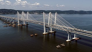
The Tappan Zee Bridge, officially named the Governor Mario M. Cuomo Bridge after the former New York governor, is a twin cable-stayed bridge spanning the Tappan Zee section of the Hudson River between Tarrytown and Nyack in the U.S. state of New York. It was built to replace the original Tappan Zee Bridge opened in 1955, which was located just to the south. The bridge's north span carries the northbound and westbound automobile traffic of the New York State Thruway, Interstate 87 (I-87) and I-287; it also carries a shared use path for bicycles and pedestrians. The south span carries southbound and eastbound automobile traffic.

<span class="mw-page-title-main">Indian River Inlet Bridge</span> Bridge in United States of America

The Indian River Inlet Bridge is a cable-stayed bridge located in Sussex County, Delaware, in the United States. It carries four lanes of Delaware Route 1 over the Indian River Inlet between the Indian River Bay and the Atlantic Ocean. The bridge also carries Delaware Bicycle Route 1 across the inlet. The bridge is within Delaware Seashore State Park between Dewey Beach and Bethany Beach. The Indian River Inlet Bridge is maintained by the Delaware Department of Transportation (DelDOT). The bridge is 2,600 feet (790 m) long and 107.66 feet (32.81 m) wide, with a span of 950 feet (290 m) and overhead clearance of 45 feet (14 m).

The New Haven Harbor Crossing Corridor Improvement Program is a $2 billion megaproject in the city of New Haven, Connecticut, to reconstruct and widen some 13 miles of highway in the New Haven area, which included 7.2 miles of Interstate 95 along with other related transportation improvements. The centerpiece of the project is the replacement of the Pearl Harbor Memorial Bridge, which carries Interstate 95 over the Quinnipiac River. The program also included the reconstruction of parts of Interstate 91, Connecticut Route 34, and US Route 1 that connect to and run near the interchange, as well as other transportation upgrades.

<span class="mw-page-title-main">Champlain Bridge (Montreal, 2019–present)</span> Bridge over the Saint Lawrence River in Montreal, Canada

The Samuel De Champlain Bridge, colloquially known as the Champlain Bridge, is a cable-stayed bridge design by architect Poul Ove Jensen and built to replace the original Champlain Bridge over the Saint Lawrence River in Quebec, between Nuns' Island in the borough of Verdun in Montreal and the suburban city of Brossard on the South Shore. A second, connected bridge links Nuns' Island to the main Island of Montreal. The bridge is the busiest bridge in the country with more cars flowing into it than any other bridge.

References

  1. CONNDOT
  2. Moses Wheeler Bridge Replacement Project by STV Archived 2007-11-13 at the Wayback Machine
  3. Moses Wheeler Bridge Closes Lane, WVIT TV Hartford, CT, August 13, 2007
  4. CONNDOT Special Construction Notice