Henry Vaughan was a Welsh metaphysical poet, author, translator and physician, who wrote in English. He is chiefly known for the religious poetry contained in Silex Scintillans, published in 1650, with a second part published in 1655. In 1646 his Poems, with the Tenth Satyre of Juvenal Englished was published, followed by a second volume in 1647. Meanwhile, he had been "converted" by reading the religious poet George Herbert and gave up "idle verse". The prose Mount of Olives: or, Solitary Devotions (1652) show the depth of his religious convictions and the authenticity of his poetic genius. Two more volumes of secular verse were published, ostensibly without his sanction; but it is his religious verse that has become acclaimed. He also translated short moral and religious works and two medical works in prose. At some time in the 1650s he began to practise medicine and continued to do so throughout his life.

Deheubarth was a regional name for the realms of south Wales, particularly as opposed to Gwynedd. It is now used as a shorthand for the various realms united under the House of Dinefwr, but that Deheubarth itself was not considered a proper kingdom on the model of Gwynedd, Powys, or Dyfed is shown by its rendering in Latin as dextralis pars or as Britonnes dexterales and not as a named land. In the oldest British writers, Deheubarth was used for all of modern Wales to distinguish it from Hen Ogledd, the northern lands whence Cunedda and the Cymry originated.

City Hall is a civic building in Cathays Park, Cardiff, Wales, UK. It serves as Cardiff's centre of local government. It was built as part of the Cathays Park civic centre development and opened in October 1906. Built of Portland stone, it is an important early example of the Edwardian Baroque style.
Neath North is an electoral ward of Neath Port Talbot county borough, Wales falling within the community of Neath.
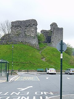
Llandovery Castle is a late thirteenth-century, Grade II*-listed, castle ruin in the town of Llandovery in Carmarthenshire, Wales. It occupies a knoll overlooking the River Towy and the land surrounding it. The Normans built a castle in the current location in the early twelfth century and this was rebuilt in stone. It was burnt in the early sixteenth century and never repaired.
Pontllanfraith is a large village and community located in the Sirhowy Valley in Caerphilly county borough, Wales, within the historic boundaries of Monmouthshire. It is situated adjacent to the town of Blackwood, with the Sirhowy River passing through both locations. The village includes the communities of the Penllwyn, Springfield, Woodfieldside and The Bryn. The population of the community at the 2011 census was 8,552.
The A307 road runs 13.2 miles (21.2 km) through SW London and NW Surrey. It is primary at the north-east end; the remainder is non-primary, generally superseded in the mid-twentieth century in two stages by newer alignments of the Portsmouth Road, the Kingston bypass and Esher bypass of the A3 road which runs along a slightly oblique axis.
Grosmont is a village and community near Abergavenny in Monmouthshire, Wales. The population taken at the 2011 census was 920. The wider community (parish) includes the villages of Llangattock Lingoed, Llangua and Llanvetherine.
Llanbethery is a small village in the Vale of Glamorgan, south Wales. It is part of the community of Llancarfan.

Michaelston-le-Pit is a village in the Vale of Glamorgan, just to the west of the city of Cardiff, Wales. It is part of the Michaelston-le-Pit and Leckwith community. The community population taken at the 2011 census was 309.
Llanfihangel Aberbythych is a community in Carmarthenshire, Wales. The population recorded at the 2011 census was 1,344. It is bordered by Llangathen, Llandeilo, Dyffryn Cennen, Llandybie, Gorslas and Llanarthney, all of which are in Carmarthenshire.

The Trawsgoed Estate is an estate located eight miles (13 km) east of Aberystwyth in Ceredigion, Wales and in the community of Trawsgoed that has been in the possession of the Vaughan family since 1200. The family are descended from Collwyn ap Tangno, founder of the fifth noble tribe of North Wales, Lord of Eifionydd, Ardudwy, and part of Llŷn, who had his residence on the site of Harlech Castle. The land falls within the ancient parish of Llanafan, in the upper division of the hundred of Ilar. In Wales, an ancient parish was a village or group of villages or hamlets and the adjacent lands. Originally they held ecclesiastical functions, but from the sixteenth century they also acquired civil roles. The parish may have been established as an ecclesiastical parish. Originally a medieval administrative unit, after 1597 ecclesiastical units were separated from civil parishes to serve the ecclesiastical needs of the local community. The Trawsgoed estate extended over 22 Cardiganshire parishes, including Llanafan. The community of Trawsgoed has a population of 989 (2011).

Llangattock is a village, community and electoral ward in the Brecon Beacons National Park in Powys, Wales. It lies in the Usk Valley just across the river from the town of Crickhowell. The Monmouthshire and Brecon Canal passes through the village en route between Brecon and Pontypool. It is in the historic county of Breconshire.
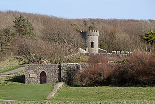
Dunraven Castle was a mansion on the South Wales coast near Southerndown. The existing manor house was rebuilt as a castellated hunting lodge in the early 19th century and was extensively remodelled later in the century. The surviving parts of the house and its lands are Grade II listed buildings.
Monmouth Comprehensive School is a comprehensive secondary school for pupils aged 11–18, situated in Monmouth, Monmouthshire, Wales.

Cwmwysg is a small rural community southwest of Trecastle in the valley of the Usk river, Powys, Wales.

St James the Great is a church located opposite the Cardiff Royal Infirmary on Newport Road, near the centre of Cardiff, Wales. It closed in 2006 after 112 years as an Anglican place of worship.
Derwydd is a hamlet in the south-east of Carmarthenshire, Wales, historically situated in the parish of Llandybie, north of Ammanford. It is around halfway between Ammanford and Llandeilo, at a rural crossroads between the A483 and A476 roads.
Gabalfa is a proposed railway station which would be constructed on the Merthyr Line as part of the South Wales Metro. It is included as part of the Wales & Borders franchise and is planned to open in 2028.
Herbert Millingchamp Vaughan was a Welsh author, historian, and bibliographer.


