
Rufiji is one of the six districts of the Pwani Region of Tanzania. It is bordered to the north by the Kisarawe and Mkuranga Districts, to the east by the Indian Ocean, to the south by the Kilwa District, Lindi Region and to the west by the Morogoro Region. The district capital is the town of Utete on the southern banks of the Rufiji River.
Morogoro Region is one of Tanzania's 31 administrative regions. It covers an area of 70,624 km2 (27,268 sq mi). and is comparable in size to the combined land area of the nation state of Ireland. Morogoro Region is bordered to the north by the Manyara Region and Tanga Region, to the east by the Pwani and Lindi Regions, to the south by the Ruvuma Region and to the west by the Iringa Njombe and Dodoma Regions. The regional capital is the municipality of Morogoro. According to the 2022 national census, the region had a population of 3,197,104.
Nzega District is one of the seven districts of the Tabora Region of Tanzania. It is bordered to the north by Shinyanga Region, to the south and southwest by Uyui District and to the east by Igunga District. Its administrative seat is the town of Nzega.
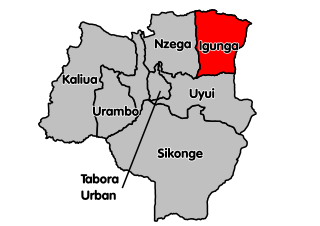
Igunga is one of the seven districts of the Tabora Region of Tanzania. It is bordered to the north by the Shinyanga Region, to the east by the Singida Region, to the south by the Uyui District and to the west by the Nzega District. Its administrative seat is the town of Igunga. Igunga is now divided by two Constituencys: Igunga Constituency and Manonga Constituency, whereby Manonga town is Choma Chankola. Igunga is the second district in production

Liwale is one of the six districts of the Lindi Region of Tanzania. It is the largest district in Lindi and one of the largest in districts in Tanzania. It is bordered to the north by the Pwani Region, to the east by the Kilwa District, to the south by the Ruangwa District and to the west by the Morogoro Region. Most of Liwale district is within the Nyerere National Park.
Kilolo is one of the four districts of the Iringa Region of Tanzania. It is bordered to the north and east by the Morogoro Region, to the south by Mufindi District and to the west by the Iringa Rural District. The district is home to the Udzungwa Mountains National Park.

Mufindi District is one of the four districts of the Iringa Region of Tanzania. It is bordered to the north by Kilolo District and Iringa Urban District, to the south by the Njombe Region, to the east by the Morogoro Region and to the west by the Singida Region.

Kilosa District is one of the six districts of the Morogoro Region of Tanzania. Its administrative seat is the town of Kilosa. Kilosa District covers 14,918 square kilometres (5,760 sq mi). It is bordered to the north by the Manyara Region, to the northeast by the Tanga Region, to the east by Mvomero District, to the southeast by Morogoro Rural District, to the south by Kilombero District, to the southwest by the Iringa Region and to the west by the Dodoma Region. Kilosa District is home to Mikumi National Park.

Mvomero is one of the six districts of the Morogoro Region of Tanzania. It is bordered to the north by the Tanga Region, to the northeast by the Pwani Region, to the east and southeast by Morogoro Rural District and Morogoro Urban District and to the west by Kilosa District.

Morogoro Rural District is one of the six districts of the Morogoro Region of Tanzania. Morogoro Rural District covers 19,056 square kilometres (7,358 sq mi). It is bordered to the north and east by the Pwani Region, to the south by Kilombero District, to the southwest by the Kilosa District and to the west by the Mvomero District and the Morogoro Urban District.
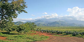
Mlimba is a town in central Tanzania on the plains.
Baray is an administrative ward in the Karatu district of the Arusha Region of Tanzania. The ward is home to the Hadza. According to the 2012 census, the ward has a total population of 23,554.
Ngerengere River is a river of the Morogoro Region of Tanzania. It rises in the Uluguru Mountains, and flows eastwards to join the Ruvu River at approximately 7.05085 S, 38.51571 E. The city of Morogoro is on the Ngerengere River.
Mandege is an administrative ward in Gairo District in the Morogoro Region of Tanzania, East Africa. As of August 2022, the population of the ward was 9,625. The Mandege Forest Station, headquarters for the Mamiwa Forest Reserve, is located there.

Morogoro Airstrip is an airstrip serving the city of Morogoro in the Morogoro Region of Tanzania. It is 3.5 kilometres (2.2 mi) north of the town. The airstrip location is just off the western side of the prohibited airspace (HTP6) of the Ngerengere Air Force Base but lies within the restricted airspace (HTR7).

The Tanzania Air Force Command is the aerial service branch of the Tanzania People's Defence Force (TPDF). The current commander of the Tanzania Air Force Command is Major General Shaban Mani, who replaced major general Ingram upon the latter's retirement in 2021.
Ngerengere Air Force Base is a military airbase of the Tanzania Air Force Command. It is located about 120 kilometres (75 mi) west of Dar es Salaam, in Ngerengere ward, Morogoro District of Morogoro Region in Tanzania.

Chamwino District is one of the seven districts of the Dodoma Region of Tanzania. It is bordered to the north by Chemba District, to the east by Manyara Region, Kongwa District and Mpwapwa District, to the south by Iringa Region, and to the west by Singida Region, Bahi District and Dodoma District. Its administrative seat is the town of Chamwino.

The Ruvu River is a river in eastern Tanzania.
