
The Geography of Kenya is diverse, varying amongst its 47 counties. Kenya has a coastline on the Indian Ocean, which contains swamps of East African mangroves. Inland are broad plains and numerous hills. Kenya borders South Sudan to the northwest, Uganda to the west, Somalia to the east, Tanzania to the south, and Ethiopia to the north.

Nyeri is a town situated in the Central Highlands of Kenya. It is the county headquarters of Nyeri County. The town was the central administrative headquarters of the country's former Central Province. Following the dissolution of the former provinces by Kenya's new constitution on 26 August 2010, the city is situated about 150 km north of Kenya's capital Nairobi, in the country's densely populated and fertile Central Highlands, lying between the eastern base of the Aberdare (Nyandarua) Range, which forms part of the eastern end of the Great Rift Valley, and the western slopes of Mount Kenya.
Tsavo East National Park is a national park in Kenya with an area of 13,747 km2 (5,308 sq mi). It was established in April 1948 and covers a semi-arid area previously known as the Taru Desert. Together with the Tsavo West National Park, it forms an area of about 22,000 square kilometers. The Tsavo River flows west to east through the national park, which is located in the Taita-Taveta County of the former Coast Province.

The Luigi Broglio Space Center (BSC) located near Malindi, Kenya, is an Italian Space Agency (ASI) Spaceport. It was named after its founder and Italian space pioneer Luigi Broglio. Developed in the 1960s through a partnership between the Sapienza University of Rome's Aerospace Research Centre and the National Aeronautics and Space Administration (NASA), the BSC served as a spaceport for the launch of both Italian and international satellites (1967–1988). The center comprises a main offshore launch site, known as the San Marco platform, as well as two secondary control platforms and a communications ground station on the mainland.

Lake Nakuru is one of the Rift Valley lakes at an elevation of 1,754 m (5,755 ft) above sea level. It lies to the south of Nakuru, in the rift valley of Kenya and is protected by Lake Nakuru National Park.

The Bartang is a river of Central Asia, tributary to the Panj and consequently to the Amu Darya. In its upper reaches, it is also known as the Murghab and Aksu; it flows through the Wakhan in Afghanistan, then through the Rushon District of the Gorno-Badakhshan autonomous region, Tajikistan. The river is 528 kilometres (328 mi) long and has a basin area of 24,700 square kilometres (9,500 sq mi).

Ojców National Park is a national park in Kraków County, Lesser Poland Voivodeship in southern Poland, established in 1956. It takes its name from the village of Ojców, where it also has its headquarters. Chopin visited Ojców in 1829.

Kitui County is a county in the former Eastern Province of Kenya. Its capital and largest town is Kitui, although Mwingi is also another major urban centre. The county has a population of 1,136,187. and an area of 30,430 km2. It lies between latitudes 0°10 South and 3°0 South and longitudes 37°50 East and 39°0 East.
Kersa is Districts of Ethiopia in the East Hararghe Zone of the Oromia, Ethiopia. It is named after a river that flows through it, the Kersa. The district is bordered on the south by Bedeno, on the west by Meta, on the north by Dire Dawa, on the northeast by Haro Maya, and on the southeast by Kurfa Chele. The administrative center of the district is Kersa; other towns include Langey.Before modern kersa established the city mid 17 century the Arab trader exchange bartery clothes with potate and cow goat and sheep. This area is Richest uranium deposit pegmatite rock and pitblende type of uranium.but our people growth chat crop in these area there is sweet chat when chewing it's a good "mirqaana" but a great health influence in this society this mineral dangerous health problems.

The developing nations of Africa are popular locations for the application of renewable energy technology. Currently, many nations already have small-scale solar, wind, and geothermal devices in operation providing energy to urban and rural populations. These types of energy production are especially useful in remote locations because of the excessive cost of transporting electricity from large-scale power plants. The applications of renewable energy technology has the potential to alleviate many of the problems that face Africans every day, especially if done in a sustainable manner that prioritizes human rights.
Lokitaung is a settlement in Kenya's Turkana County, a few miles inland of northwest Lake Turkana. Lokitaung is the site of the 36-million year old Lokitaung Basalt lava flows, which lay atop Cretaceous sediments including dinosaur bones. The basalts are over 1 kilometer thick, and approximately 100 kilometers wide.
The men's 3000 metres steeplechase was the only steeplechase on the Athletics at the 1968 Summer Olympics program in Mexico City. It was held on 14 October and 16 October 1968.
The space programme of Kenya has been largely shaped by Kenya's equatorial latitude, and has basis of existed foreign infrastructure and experience. The development of the programme started in May 2012.

Longido District is one of seven districts of the Arusha Region of Tanzania. The district is bordered to the east by the Ngorongoro District, to the south west by the Monduli District and southeast by the Arusha Rural District and Meru District. To the far east by Siha District of Kilimanjaro Region and the north by Kenya. It covers an area of 7,885 km2 (3,044 sq mi). The district is comparable in size to the land area of Puerto Rico.Longido District was created in 2007 from Monduli District. Mount Longido, Gelai and Kitumbeine volcano are all located within the boundaries of the district. The administrative seat is the town of Longido. According to the 2012 census, the population of the district was 123,153. Longido District is known as Arusha's gem district as its home to Anyolite and Rubies.

The women's marathon event at the 2016 Summer Olympics took place on 14 August on the Sambadrome.

Lonah Korlima Chemtai Salpeter is a Kenyan-Israeli runner. She won the bronze medal in the marathon at the 2022 World Athletics Championships. At the European Athletics Championships, Chemtai took victory in the 10,000 metres in 2018 and earned bronze in 2022. She won the 2020 Tokyo Marathon, finished second at the 2022 New York City Marathon and third at the 2023 Boston Marathon.
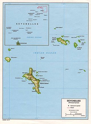
The geology of Seychelles is an example of a felsic granite microcontinent that broke off from the supercontinent Gondwana within the past 145 million years and become isolated in the Indian Ocean. The islands are primarily granite rock, with some sequences of sedimentary rocks formed during rift basin periods or times when the islands were submerged in shallow water.
The geology of Uganda extends back to the Archean and Proterozoic eons of the Precambrian, and much of the country is underlain by gneiss, argillite and other metamorphic rocks that are sometimes over 2.5 billion years old. Sedimentary rocks and new igneous and metamorphic units formed throughout the Proterozoic and the region was partially affected by the Pan-African orogeny and Snowball Earth events. Through the Mesozoic and Cenozoic, ancient basement rock has weathered into water-bearing saprolite and the region has experienced periods of volcanism and rift valley formation. The East Africa Rift gives rise to thick, more geologically recent sediment sequences and the country's numerous lakes. Uganda has extensive natural resources, particularly gold.
Ras Ngomeni is a cape on the Indian Ocean coast of Kenya. A Swahili settlement lay just to its south between the 5th and 13th centuries. It continued as a harbour into the 16th century.
Ruweida Mohamed Obo was born in 1978, in Pate Island, Lamu County. She is a Kenyan politician.
