Related Research Articles

The Ngorongoro Conservation Area is a protected area and a World Heritage Site located 180 km (110 mi) west of Arusha in the Crater Highlands area of Tanzania. The area is named after Ngorongoro Crater, a large volcanic caldera within the area. The conservation area is administered by the Ngorongoro Conservation Area Authority, an arm of the Tanzanian government, and its boundaries follow the boundary of the Ngorongoro Division of the Arusha Region.

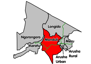
Monduli District is one of the seven districts of the Arusha Region of Tanzania. It is located in the northeastern section of the country. It is bordered to the north by Longido District, to the east by Arusha Rural District, to the south by the Manyara Region and to the west by Ngorongoro District and Karatu District. The town of Monduli is the administrative seat of the district. According to the 2002 Tanzania National Census, the population of the Monduli District was 185,237. By 2012, the population of the district was 158,929. The population decreased, as Longido District was split off.

Karatu District is one of the seven districts in the Arusha Region of Tanzania. It is bordered by the Ngorongoro District to the north, the Shinyanga Region to the west, the Monduli District to the east, and the Manyara Region to the south and southeast.

Ngorongoro District is one of the five districts of the Arusha Region of Tanzania. It is bordered to the north by Kenya, to the east by Monduli District, to the south by the Karatu District and to the west by the Mara Region.
Arash is an administrative ward in the Ngorongoro District of the Arusha Region of Tanzania. According to the 2002 census, Arash has a total population of 8,503.
Digodigo is an administrative ward in the Ngorongoro District of the Arusha Region of Tanzania. According to the 2002 census, the ward has a total population of 10,831. Digodigo is central part of Sale Division, it is endowed with water for irrigation system therefore able to provides all type of vegetables and fruits to the district headquarters as the other part of the district is dry. Digo digo is the second largest developed area and center of business within the districts with more than 50 retail shops,5 quest houses, and other more public services as the area is developing very fast
Enduleni is an administrative ward in the Ngorongoro District of the Arusha Region of Tanzania. According to the 2002 census, the ward has a total population of 11,738.
Kakesio is an administrative ward in the Ngorongoro District of the Arusha Region of Tanzania. According to the 2002 census, the ward has a total population of 4,135.
Nainokanoka is an administrative ward in the Ngorongoro District of the Arusha Region of Tanzania. According to the 2002 census, the ward has a total population of 15,606.
Nayobi is an administrative ward in the Ngorongoro District of the Arusha Region of Tanzania. According to the 2002 census, the ward has a total population of 11,011.
Olbalbal is an administrative ward in the Ngorongoro District of the Arusha Region of Tanzania. According to the 2002 census, the ward has a total population of 7,561.
Oldonyo-Sambu is an administrative ward in the Ngorongoro District of the Arusha Region of Tanzania. According to the 2002 census, the ward has a total population of 3,256.
Orgosorok is an administrative ward in the Ngorongoro District of the Arusha Region of Tanzania. According to the 2002 census, the ward has a total population of 16,064.
Pinyinyi is an administrative ward in the Ngorongoro District of the Arusha Region of Tanzania. According to the 2002 census, the ward has a total population of 5,574.
Sale is an administrative ward in the Ngorongoro District of the Arusha Region of Tanzania. According to the 2002 census, the ward has a total population of 2,904.
Soit Sambu is an administrative ward in the Ngorongoro District of the Arusha Region of Tanzania. According to the 2002 census, the ward has a total population of 13,147.
Mto wa Mbu is an administrative ward in the Monduli district of the Arusha Region of Tanzania. According to the 2012 census, the ward had a total population of 11,405. The name Mto wa Mbu means " Mosquitoes' River ". Mto wa Mbu has an area of 3,600 square kilometres (1,400 sq mi) of which 1,800 square kilometres (690 sq mi) is for cultivation. Mto wa Mbu is estimated to be in the midway between the neighbouring Karatu and Makuyuni towns. It is one of the towns in the rift valley in the northern part of Tanzania. It close to lake Manyara and Manyara national park. The town of Mto wa Mbu features lodges, rest houses and camp sites for tourists who visit Lake Manyara and Manyara national park. Banana is the common and largest agricultural product in the town and the surrounding area. Mto wa Mbu is can be reached by driving from Arusha. It is approximately 112 km from Arusha city and the road is well repaired with tarmac. Tourists vehicles from Arusha, Nairobi, Moshi and Babati always passes through this town on the way to Ngorongoro crater and Serengeti national park.
Mbulumbulu is an administrative ward in the Karatu district of the Arusha Region of Tanzania. According to the 2002 census, the ward has a total population of 17,418.
Ufana is an administrative ward in the Kongwa district of the Dodoma Region of Tanzania. According to the 2002 census, the ward has a total population of 14,520.
Itunundu is an administrative ward in the Iringa Rural district of the Iringa Region of Tanzania. According to the 2002 census, the ward has a total population of 18,962.
References
- ↑ "2002 Population and Housing Census General Report". Government of Tanzania. Archived from the original on 2004-09-04. Retrieved 2008-08-19.CS1 maint: discouraged parameter (link)
Coordinates: 3°15′S35°31′E / 3.250°S 35.517°E