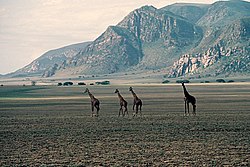
Malambo, Tanzania

Last updated

Malambo, Arusha Region

Giraffe on Plain near Malambo Village, Arusha Region 1985 Tanzania, near Malambo, giraffe.jpg
Giraffe on Plain near Malambo Village, Arusha Region

Malambo is a village in northern Tanzania, located near the Sanjan River, east of the Serengeti, west of Lake Natron, and north of Ngorongoro, in a picturesque but remote region. It is on the western edge of the Eastern Rift Valley, bordered by mountains on the west and a vast plain on the east.

Tanzania Country in Africa

Tanzania officially the United Republic of Tanzania, is a country in eastern Africa within the African Great Lakes region. It borders Uganda to the north; Kenya to the northeast; Comoro Islands at the Indian Ocean to the east; Mozambique and Malawi to the south; Zambia to the southwest; and Rwanda, Burundi, and the Democratic Republic of the Congo to the west. Mount Kilimanjaro, Africa's highest mountain, is in north-eastern Tanzania.

Serengeti geographical region in Africa

The Serengeti ecosystem is a geographical region in Africa. It is located in northern Tanzania. It spans approximately 30,000 km2 (12,000 sq mi).

Lake Natron salt lake

Lake Natron is a salt or soda lake in Arusha Region in Tanzania. It is in the Gregory Rift, which is the eastern branch of the East African Rift. The lake is within the Lake Natron Basin, a Ramsar Site wetland of international significance.

Contents

Malambo has served as home for many Maasai, and a rest stop for many more who pass through the region. It boasts a school, a medical clinic, a maternity clinic, and a small airstrip, though the village is still considered remote and impoverished. Because it is close to areas that are popular tourist safari attractions, visitors occasionally pass through.

Maasai people ethnic group inhabiting Kenya, Tanzania and Uganda

The Maasai are a Nilotic ethnic group inhabiting northern, central and southern Kenya and northern Tanzania. They are among the best known local populations internationally due to their residence near the many game parks of the African Great Lakes, and their distinctive customs and dress. The Maasai speak the Maa language, a member of the Nilo-Saharan family that is related to the Dinka, Kalenjin and Nuer languages. Some have become educated in the official languages of Kenya and Tanzania, Swahili and English. The Maasai population has been reported as numbering 841,622 in Kenya in the 2009 census, compared to 377,089 in the 1989 census.

Notable people

Latang'amwaki Ndwati Mollel

Agbert Tajewo Mollel (Ngorongoro District)

Malambo, Rukwa Region

Malambo' is a village in western Tanzania on the road between Sumbawanga, the capital of Rukwa Region, and Kigoma, the port city on the northern shore of Lake Tanganyika. It is on the western edge of Katavi National Park, a rarely visited park abundant with wildlife. This western area of Tanzania is remote with few tourist facilities and rarely visited by tourist safaris.

Sumbawanga Place in Rukwa Region, Tanzania

Sumbawanga is a city located in western Tanzania. It is the capital of Rukwa Region with postcode number 55100. The regional population is approximately 150,000 based on a 2002 census. Sumbawanga lies in the territory of the Wafipa Fipa tribe and so many people speak Kifipa, as well as Kiswahili, the most widely used language of Tanzania. The name of the town literally translates as "throw away your witchcraft", thought to be a warning from local spiritual "healers" to any bringing in superstitions and practices relating to spiritual healers from other areas; there are still some healers who practice both in town and in the surrounding smaller villages on the plateau. The town has the largest hospital in the region, Rukwa General Hospital, which is government funded, as well as the smaller Dr. Atiman Hospital administrated and run by the Catholic Diocese of Sumbawanga.

Rukwa Region Region in Southern Highlands, Tanzania

Rukwa Region is one of Tanzania's 31 administrative regions with a postcode number 55000. The regional capital is the municipality of Sumbawanga. According to the 2012 national census, the region had a population of 1,004,539. For 2002-2012, the region's 3.2 percent average annual population growth rate was tied for the third highest in the country. It was also the twentieth most densely populated region with 44 people per square kilometer.

Kigoma Place in Kigoma Region, Tanzania

Kigoma is a town and lake port in north western Tanzania, on the north eastern shores of Lake Tanganyika and close to the border with Burundi and The Democratic Republic of the Congo. It serves as the capital for the surrounding Kigoma Region and has a population of 135,234 and an elevation of 775 m.

Coordinates: 02°30′S35°36′E / 2.500°S 35.600°E / -2.500; 35.600

Geographic coordinate system Coordinate system

A geographic coordinate system is a coordinate system that enables every location on Earth to be specified by a set of numbers, letters or symbols. The coordinates are often chosen such that one of the numbers represents a vertical position and two or three of the numbers represent a horizontal position; alternatively, a geographic position may be expressed in a combined three-dimensional Cartesian vector. A common choice of coordinates is latitude, longitude and elevation. To specify a location on a plane requires a map projection.


Related Research Articles

Geography of Tanzania

Tanzania comprises many lakes, national parks, and Africa's highest point, Mount Kilimanjaro. Northeast Tanzania is mountainous, while the central area is part of a large plateau covered in grasslands. The country also contains the southern portion of Lake Victoria on it's northern border with Uganda and Kenya.

Serengeti National Park national park in Africa

The Serengeti National Park is a Tanzanian national park in the Serengeti ecosystem in the Mara and Simiyu regions. It is famous for its annual migration of over 1.5 million white-bearded wildebeest and 250,000 zebra and for its numerous Nile crocodile and honey badger.

Tourism in Albania

Tourism in Albania has been a key element to the country's economic activity and is constantly developing. It is characterized by its rich archaeological and cultural heritage dating back to the classical period when Illyrians and Ancient Greeks inhabited the region. Over the course of history, the territory of Albania was occupied and populated by Romans, Byzantines, Venetians and Ottomans. Notably the country features unspoiled beaches, mountainous landscapes, traditional cuisine, archaeological artifacts, unique traditions, low prices and the wild atmosphere of the countryside.

Wasatch Range Mountain range in Utah, United States

The Wasatch Range is a mountain range that stretches approximately 160 miles (260 km) from the Utah-Idaho border, south through central Utah in the western United States. It is the western edge of the greater Rocky Mountains, and the eastern edge of the Great Basin region. The northern extension of the Wasatch Range, the Bear River Mountains, extends just into Idaho, constituting all of the Wasatch Range in that state.

Lake Manyara salinity

Lake Manyara is the seventh-largest lake of Tanzania by surface area, at 470-square-kilometre (180 sq mi). It is a shallow, alkaline lake in the Natron-Manyara-Balangida branch of the East African Rift in Manyara Region in Tanzania. Said by Ernest Hemingway to be the "loveliest [lake] ... in Africa". The northwest quadrant of the lake is included within Lake Manyara National Park and it is part of the Lake Manyara Biosphere Reserve, established in 1981 by UNESCO as part of its Man and the Biosphere Programme.

Ngorongoro Conservation Area Protected area

The Ngorongoro Conservation Area is a protected area and a World Heritage Site located 180 km (110 mi) west of Arusha in the Crater Highlands area of Tanzania. The area is named after Ngorongoro Crater, a large volcanic caldera within the area. The conservation area is administered by the Ngorongoro Conservation Area Authority, an arm of the Tanzanian government, and its boundaries follow the boundary of the Ngorongoro Division of the Arusha Region.

Arusha Region Region in Northern, Tanzania

Arusha Region is one of Tanzania's 31 administrative regions. Its capital and largest city is the city of Arusha. The region is bordered by Kajiado County and Narok County in Kenya to the north, the Kilimanjaro Region to the east, the Manyara and Singida regions to the south, and the Mara and Simiyu regions to the west. Major towns include Monduli, Namanga, Longido, and Loliondo to the north, Mto wa Mbu and Karatu to the west, and Usa River to the east. The region is comparable in size to the combined land and water areas of the United States state of Maryland.

Lake Manyara National Park national park

Lake Manyara National Park is a protected area in Tanzania's Arusha and Manyara Regions, situated between Lake Manyara and the Great Rift Valley. It covers an area of 325 km2 (125 sq mi) including about 230 km2 (89 sq mi) lake surface. More than 350 bird species have been observed on the lake.

Arusha National Park National Park in Tanzania

Arusha National Park covers Mount Meru, a prominent volcano with an elevation of 4566 m, in the Arusha Region of north eastern Tanzania. The park is small but varied with spectacular landscapes in three distinct areas. In the west, the Meru Crater funnels the Jekukumia River; the peak of Mount Meru lies on its rim. Ngurdoto Crater in the south-east is grassland. The shallow alkaline Momella Lakes in the north-east have varying algal colours and are known for their wading birds.

Monduli District District in Arusha Region, Tanzania

Monduli District is one of the five districts of the Arusha Region of Tanzania. It is located in the northeastern section of the country. It is bordered to the north by Kenya, to the east by the Kilimanjaro Region and Arumeru District, to the south by the Manyara Region and to the west by Ngorongoro District and Karatu District. The town of Monduli is the administrative seat of the district. According to the 2002 Tanzania National Census, the population of the Monduli District was 185,237.

Ngorongoro District District in Northern, Tanzania

Ngorongoro District is one of the five districts of the Arusha Region of Tanzania. It is bordered to the north by Kenya, to the east by Monduli District, to the south by the Karatu District and to the west by the Mara Region.

Loliondo Village in Arusha Region, Tanzania

Loliondo village is situated in Ngorongoro District of Arusha Region in Northern Tanzania. Together with neighbouring Wasso village, it hosts the district offices and forms the commercial centre of Loliondo division. Loliondo is the seat of the current District Commissioner for Ngorongoro.

Olduvai Gorge Museum

The Olduvai Gorge Museum is located in the Ngorongoro Conservation Area in Northern Tanzania on the edge of the Olduvai Gorge. The museum was founded by Mary Leakey and is now under the jurisdiction of the Tanzanian government's Department of Cultural Antiquities. It is a museum dedicated to the appreciation and understanding of the Olduvai Gorge and Laetoli fossil sites.

Crater Highlands massif

The Crater Highlands are a region along the East African Rift in the Arusha and Manyara Regions of northern Tanzania.

Tourism in Tanzania

Tanzania is a country with many tourist attractions. Approximately 38 percent of Tanzania's land area is set aside in protected areas for conservation. There are 16 national parks, 29 game reserves, 40 controlled conservation areas and marine parks. Tanzania is also home to Mount Kilimanjaro, the highest point in Africa.

Lolland island of Denmark

Lolland is the fourth largest island of Denmark, with an area of 1,243 km2 (480 sq mi). Located in the Baltic Sea, it is part of Region Sjælland. As of 1 January 2013, it has 62,578 inhabitants.

Magugu is an administrative ward in the Babati district of the Manyara Region of Tanzania. According to the 2002 census, the ward has a total population of 23,682. It is famous for its aromatic rice.

Wildlife of Tanzania

Tanzania contains some 20 percent of the species of Africa’s large mammal population, found across its reserves, conservation areas, marine parks, and 17 national parks, spread over an area of more than 42,000 square kilometres (16,000 sq mi) and forming approximately 38 percent of the country's territory. Wildlife resources of Tanzania are described as "without parallel in Africa" and "the prime game viewing country". Serengeti National Park, the country's second largest national park area at 14,763 square kilometres (5,700 sq mi), is located in northern Tanzania and is famous for its extensive migratory herds of wildebeests and zebra while also having the reputation as one of the great natural wonders of the world. The Ngorongoro Conservation Area, established in 1959, is a UNESCO World Heritage Site and inhabited by the Maasai people. Its Ngorongoro Crater is the largest intact caldera in the world.

Gregory Rift

The Gregory Rift is the eastern branch of the East African Rift fracture system. The rift is being caused by the separation of the Somali plate from the Nubian plate, driven by a thermal plume. Although the term is sometimes used in the narrow sense of the Kenyan Rift, the larger definition of the Gregory Rift is the set of faults and grabens extending southward from the Gulf of Aden through Ethiopia and Kenya into Northern Tanzania, passing over the local uplifts of the Ethiopian and Kenyan domes. Ancient fossils of early hominins, the ancestors of humans, have been found in the southern part of the Gregory Rift.