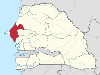
Thiès is a region of western Senegal. The capital is also called Thiès.

Val-de-Reuil is a commune in the Eure department in Normandy in north-western France. It is located south of Rouen in a loop of the Seine. Created as the new town of Le Vaudreuil in 1972, its name was changed to Val-de-Reuil in 1984 to avoid confusion with its neighbour, Le Vaudreuil.
Joal-Fadiouth is a town and urban commune in the Thiès Region at the end of the Petite Côte of Senegal, south-east of Dakar.

M'Bour or Mbour, is a city in the Thiès Region of Senegal. It lies on the Petite Côte, approximately 80 kilometres (50 mi) south of Dakar. It is home to a population of 284,189.

The 14 regions of Senegal are subdivided into 46 departments and 103 arrondissements and by collectivités locales which elect administrative officers.

Concarneau is a commune in the Finistère department of Brittany in Northwestern France. Concarneau is bordered to the west by the Baie de La Forêt.

Dakoro is a town and commune located in the Maradi Region of Niger. As of 2012, it had a population of 71,201. It is the capital of the Dakoro Department.

M'bour department is one of the 46 departments of Senegal, one of three in the Thiès region. Its capital is M'Bour.

Ferrières-en-Brie is a commune in the Seine-et-Marne department in the Île-de-France region in north-central France.

Wasquehal is a commune in the Nord department in northern France.

Beuvry is a commune in the Pas-de-Calais department in the Hauts-de-France region in northern France.
Nianing is a city in Petite Côte, Senegal, south of Dakar, 8 kilometres (5.0 mi) from M'Bour.
Saly is a seaside resort and urban commune in Thiès Region on the Petite Côte of Senegal, south of Dakar. It is a major tourist destination in Senegal.
Fatick is a town and urban commune in Senegal, located between M'bour and Kaolack and inhabited by the Serer people. Its 2023 population was at 39,361. It is the capital of the Fatick Region and the Fatick Department.

The Communes of Senegal are the fourth-level administrative divisions in Senegal. There are some 121 communes in Senegal which have urban status, apart from 46 communes d'arrondissement in the large towns and 370 rural communities in the countryside.
Wendou M'Bour is a town and sub-prefecture in the Gaoual Prefecture in the Boké Region of north-western Guinea. As of 2014 it had a population of 25,150 people.
Mbour Sign Language is an indigenous sign language used in a neighborhood of the city of M'Bour in Senegal. Deaf people in the neighborhood meet regularly.
Thiadiaye is a town and urban commune in the Thiès Region of western Senegal. It is located in the M'bour Department. The population in 2023 was 20,168, an increase from the 14,975 counted in 2013.
Popenguine-Ndayane is a small town and urban commune on the shore of the Atlantic Ocean in Senegal, located 70 km south of Dakar, on the Petite Côte, in the department of M'Bour in the region of Thiès Region. Since 2008, it brings together two localities, Popenguine and Ndayane.
Malicounda is a rural commune in the Sindia Arrondissement within the M'bour Department of the Thiès Region in western Senegal. At the 2013 census Malicounda had a population of 61,031 making it the second most populous rural commune after the pilgrimage site Touba Mosquée. Malicounda is also the name of three interconnected villages one of them being Malicounda Bambara, the epicentre of the FGC Abandonment Movement.


