
The Krishna River in the Deccan plateau is the third-longest river in India, after the Ganga and Godavari. It is also the fourth-largest in terms of water inflows and river basin area in India, after the Ganges, Indus and Godavari. The river, also called Krishnaveni, is 1,400 kilometres (870 mi) long and its length in Maharashtra is 282 kilometres. It is a major source of irrigation in the Indian states of Maharashtra, Karnataka, Telangana and Andhra Pradesh.

The Godavari is India's second longest river after the Ganga River and drains the third largest basin in India, covering about 10% of India's total geographical area. Its source is in Trimbakeshwar, Nashik, Maharashtra. It flows east for 1,465 kilometres (910 mi), draining the states of Maharashtra (48.6%), Telangana (18.8%), Andhra Pradesh (4.5%), Chhattisgarh (10.9%) and Odisha (5.7%). The river ultimately empties into the Bay of Bengal through an extensive network of distributaries. Measuring up to 312,812 km2 (120,777 sq mi), it forms one of the largest river basins in the Indian subcontinent, with only the Ganga and Indus rivers having a larger drainage basin. In terms of length, catchment area and discharge, the Godavari is the largest in peninsular India, and had been dubbed as the Dakshina Ganga.

Rangoli is an art form that originates from the Indian subcontinent, in which patterns are created on the floor or a tabletop using materials such as powdered limestone, red ochre, dry rice flour, coloured sand, quartz powder, flower petals, and coloured rocks. It is an everyday practice in many Hindu households; however, making it is mostly reserved for festivals and other important celebrations as it is time-consuming. Rangolis are usually made during Diwali or Tihar, Onam, Pongal, and other Hindu festivals in the Indian subcontinent, and are most often made during Diwali. Designs are passed from one generation to the next, keeping both the art form and the tradition alive.

Coastal Andhra, also known as Kosta Andhra, is a geographic region in the Indian state of Andhra Pradesh, comprising the coastal districts of the state between the Eastern Ghats and the Bay of Bengal, from the northern border with Orissa to Rayalaseema in the south. It includes major cities such as Visakhapatnam and Vijayawada as well as the state capital Amaravati and is recognized for its fertile lands, rich cultural heritage, and economic importance. Coastal Andhra plays a significant role in the state's agricultural output, particularly in rice and tobacco production, supported by abundant water resources from the Godavari, Krishna, and Penna rivers.

Telangana is a state in India situated in the south-central part of the Indian peninsula on the high Deccan Plateau. It is the eleventh largest state and the twelfth most populated state in India as per the 2011 census. On 2 June 2014, the area was separated from the northwestern part of United Andhra Pradesh as the newly formed state of Telangana, with Hyderabad as its capital. Telugu, one of the classical languages of India, is the most widely spoken and the primary official language of the state.

Kolleru Lake is one of the largest freshwater lakes in India and forms the largest shallow freshwater lake in Asia. 15 kilometers away from Eluru and 65 km from Rajamahendravaram, the lake is located between the Krishna and Godavari river deltas. Kolleru Lake is located in the Eluru district in the state of Andhra Pradesh. The lake is fed directly by water from the seasonal Budameru and Tammileru rivulets, and is connected to the Krishna and Godavari irrigation systems by over 67 major and minor irrigation canals. This lake is a major tourist attraction. Many birds migrate here in winter, such as Siberian crane, ibis, and painted storks. The lake was an important habitat for an estimated 20 million resident and migratory birds, including the grey or spot-billed pelican. The lake was declared as a wildlife sanctuary in November 1999 under India's Wildlife Protection Act of 1972, and designated a wetland of international importance in November 2002 under the international Ramsar Convention. The wildlife sanctuary covers an area of 308 km2.
Krishna is a Hindu deity.

Kakinada is a port city and municipal corporation in the Indian state of Andhra Pradesh. Situated along the Bay of Bengal, it serves as the headquarters of Kakinada district and is a significant economic and cultural centre in the region. It is the sixth most populous city in the state and is recognised as one of the most liveable and cleanest cities in India among those with a population under one million. Nicknamed the "Pensioners' Paradise," Kakinada is known for its well-planned layout and modern infrastructure.
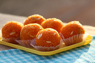
Laddu or laddoo is a spherical sweet from the Indian subcontinent made of various ingredients and sugar syrup or jaggery. It has been described as "perhaps the most universal and ancient of Indian sweets."
Sullurupeta is a town in Tirupati district of Andhra Pradesh, India. It is a municipality and the headquarters of Sullurpeta mandal and Sullurupeta revenue division. It serves as a gateway to Satish Dhawan Space Centre(SDSC) at Sriharikota.
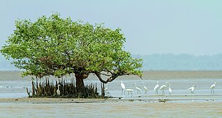
Coringa Wildlife Sanctuary is an estuary situated near Kakinada in Andhra Pradesh, India. It is the third largest stretch of mangrove forests in India with 24 mangrove tree species and more than 120 bird species. It is home to the critically endangered white-backed vulture and the long billed vulture. Mangroves are a group of trees and shrubs that live in the coastal intertidal zone, with a dense tangle of prop roots that make the trees appear to be standing on stilts above the water. This tangle of roots allows the trees to handle the daily rise and fall of tides; hence, the mangrove forest gets flooded at least twice per day. The roots also slow the movement of tidal waters, causing sediments to settle out of the water and build up the muddy bottom.

Andhra Pradesh is a state in India. Andhra Pradesh Tourism Development Corporation (APTDC) is a state government agency which promotes tourism in Andhra Pradesh, describing the state as the Koh-i-Noor of India. Andhra Pradesh has a variety of tourist attractions including beaches, hills, caves, wildlife, forests and temples.

Pulicat Lake Bird Sanctuary is a sanctuary for birds, 759 km2 in area, located in the Tirupati district of Andhra Pradesh and a protected area of the Thiruvallur District of Tamil Nadu, India. Pulicat Lake is the second largest brackish-water eco-system in India after Chilka lake in Orissa. The sanctuary's international name is Pulicat Lake Wildlife Sanctuary.

The Geography of South India comprises the diverse topological and climatic patterns of South India. South India is a peninsula in the shape of a vast inverted triangle, bounded on the west by the Arabian Sea, on the east by the Bay of Bengal and on the north by the Vindhya and Satpura ranges.

Guilandina bonduc, commonly known as grey nicker, nicker bean, fever nut or knicker nut, is a species of flowering plant in the senna tribe, Caesalpinieae, that has a pantropical distribution.

The state of Andhra Pradesh is considered one of the rich 123 bio-diversified states in India. Natural vegetation (flora) and animal life (fauna) depend mainly on climate, relief, and soil. Krishna and Godavari are the two largest rivers flowing through the state. The Andhra Pradesh Forest Department deals with protection, conservation and management of forests.

The coastline of Andhra Pradesh is located on the southeastern coast of the Indian Peninsula in the Bay of Bengal and is part of the Northern Circars. With a length of 975 km, it has the third longest coastline in India after Gujarat and Tamil Nadu. The coastal corridor boasts several ports, harbors, vast stretches of sandy beaches, wildlife and bird sanctuaries, as well as fresh water lakes and estuaries.
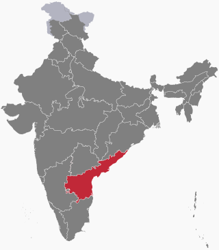
The following outline is provided as an overview of and topical guide to Andhra Pradesh:

Kolleru Bird Sanctuary is a sanctuary in Andhra Pradesh, India. It covers 673 square kilometers. It was established in November 1999, under the Wildlife Protection Act of 1972. The sanctuary protects part of the Kolleru Lake wetland, which gained Ramsar Convention for International importance in 2002.

Tourism in India is economically important and ever-growing. The World Travel & Tourism Council calculated that tourism generated ₹14.02 lakh crore (US$170 billion) or 9.6% of the nation's GDP in 2016 and supported 40.343 million jobs, 9.3% of its total employment. The sector is predicted to grow at an annual rate of 6.8% to ₹28.49 lakh crore (US$340 billion) by 2027.


