Oleśniczka is a village in the administrative district of Gmina Długołęka, within Wrocław County, Lower Silesian Voivodeship, in south-western Poland. Prior to 1945 it was in Germany.
Zabłocie is a village in the administrative district of Gmina Biała Podlaska, within Biała Podlaska County, Lublin Voivodeship, in eastern Poland. It lies approximately 14 kilometres (9 mi) west of Biała Podlaska and 94 km (58 mi) north of the regional capital Lublin.
Wólka Waniewska is a village in the administrative district of Gmina Łapy, within Białystok County, Podlaskie Voivodeship, in north-eastern Poland.
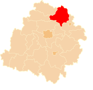
Zaleszany is a village in the administrative district of Gmina Michałowo, within Białystok County, Podlaskie Voivodeship, in north-eastern Poland, close to the border with Belarus. It lies approximately 24 kilometres (15 mi) east of Michałowo and 54 km (34 mi) east of the regional capital Białystok.
Przybudki is a village in the administrative district of Gmina Narew, within Hajnówka County, Podlaskie Voivodeship, in north-eastern Poland.
Ludwin-Kolonia is a village in the administrative district of Gmina Ludwin, within Łęczna County, Lublin Voivodeship, in eastern Poland.
Stara Prawda is a village in the administrative district of Gmina Stoczek Łukowski, within Łuków County, Lublin Voivodeship, in eastern Poland.
Zagóra is a village in the administrative district of Gmina Wola Uhruska, within Włodawa County, Lublin Voivodeship, in eastern Poland, close to the border with Ukraine.
Jarząbki is a village in the administrative district of Gmina Gnojno, within Busko County, Świętokrzyskie Voivodeship, in south-central Poland. It lies approximately 6 kilometres (4 mi) east of Gnojno, 20 km (12 mi) north-east of Busko-Zdrój, and 40 km (25 mi) south-east of the regional capital Kielce.
Budki Kotłowskie is a village in the administrative district of Gmina Żelechów, within Garwolin County, Masovian Voivodeship, in east-central Poland. It lies approximately 2 kilometres (1 mi) east of Żelechów, 24 km (15 mi) south-east of Garwolin, and 79 km (49 mi) south-east of Warsaw.
Nad Rzeką is a village in the administrative district of Gmina Żelechów, within Garwolin County, Masovian Voivodeship, in east-central Poland. It lies approximately 2 kilometres (1 mi) east of Żelechów, 24 km (15 mi) south-east of Garwolin, and 79 km (49 mi) south-east of Warsaw.
Kurówko is a village in the administrative district of Gmina Krasne, within Przasnysz County, Masovian Voivodeship, in east-central Poland. It lies approximately 13 kilometres (8 mi) south of Przasnysz and 77 km (48 mi) north of Warsaw.
Chomętów-Szczygieł is a village in the administrative district of Gmina Skaryszew, within Radom County, Masovian Voivodeship, in east-central Poland.
Kaczory is a village in the administrative district of Gmina Wiśniew, within Siedlce County, Masovian Voivodeship, in east-central Poland. It lies approximately 3 kilometres (2 mi) south of Wiśniew, 13 km (8 mi) south of Siedlce, and 90 km (56 mi) east of Warsaw.
Witoldowo is a village in the administrative district of Gmina Gostyń, within Gostyń County, Greater Poland Voivodeship, in west-central Poland. It lies approximately 7 kilometres (4 mi) west of Gostyń and 60 km (37 mi) south of the regional capital Poznań.
Jagodnia is a village in the administrative district of Gmina Miejska Górka, within Rawicz County, Greater Poland Voivodeship, in west-central Poland.
Amalka is a village in the administrative district of Gmina Sulęczyno, within Kartuzy County, Pomeranian Voivodeship, in northern Poland. It lies approximately 6 kilometres (4 mi) north-east of Sulęczyno, 27 km (17 mi) west of Kartuzy, and 55 km (34 mi) west of the regional capital Gdańsk.
Ryński Dwór is a village in the administrative district of Gmina Ryn, within Giżycko County, Warmian-Masurian Voivodeship, in northern Poland. It lies approximately 2 kilometres (1 mi) south of Ryn, 19 km (12 mi) south-west of Giżycko, and 71 km (44 mi) east of the regional capital Olsztyn.
Kocierz is a village in the administrative district of Gmina Płoty, within Gryfice County, West Pomeranian Voivodeship, in north-western Poland. It lies approximately 5 kilometres (3 mi) north of Płoty, 10 km (6 mi) south-east of Gryfice, and 67 km (42 mi) north-east of the regional capital Szczecin.
Stare Koprzywno is a former village in the administrative district of Gmina Barwice, within Szczecinek County, West Pomeranian Voivodeship, in north-western Poland. It lies approximately 5 kilometres (3 mi) west of Barwice, 27 km (17 mi) west of Szczecinek, and 118 km (73 mi) east of the regional capital Szczecin.