Elsloo is a town in the Dutch province of Limburg. It is located in the municipality of Stein, about 2 km south of the town of Stein itself. Beek-Elsloo railway station serves Elsloo. Until 1982, when it was merged with Stein, Elsloo was a separate municipality, also incorporating the smaller villages of Meers and Catsop.
Bayannuur, "Rich lake" is a sum (district) of the Bayan-Ölgii Aimag (province) in Mongolia. It is located to the very east of the aimag capital Ölgii and it has a border with the Uvs Aimag. Like in Bayan-Ölgii's other sums, Bayannuur is primarily inhabited by ethnic Kazakhs.

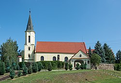
Stößen is a town in the Burgenlandkreis district, in Saxony-Anhalt, Germany. It is situated southeast of Naumburg. It is part of the Verbandsgemeinde Wethautal.
Lingapalem is a village in West Godavari district of the Indian state of Andhra Pradesh.

Bystre is a village in the administrative district of Gmina Boćki, within Bielsk County, Podlaskie Voivodeship, in north-eastern Poland. It lies approximately 10 kilometres (6 mi) south-east of Boćki, 21 km (13 mi) south of Bielsk Podlaski, and 60 km (37 mi) south of the regional capital Białystok.
Danowo is a village in the administrative district of Gmina Szczuczyn, within Grajewo County, Podlaskie Voivodeship, in north-eastern Poland.

Yellicə is a village in the Kalbajar Rayon of Azerbaijan.
Zadnoga is a village in the administrative district of Gmina Krynice, within Tomaszów Lubelski County, Lublin Voivodeship, in eastern Poland. It lies approximately 2 kilometres (1 mi) west of Krynice, 16 km (10 mi) north of Tomaszów Lubelski, and 93 km (58 mi) south-east of the regional capital Lublin.
Budynin is a village in the administrative district of Gmina Ulhówek, within Tomaszów Lubelski County, Lublin Voivodeship, in eastern Poland, close to the border with Ukraine. It lies approximately 13 kilometres (8 mi) east of Ulhówek, 38 km (24 mi) east of Tomaszów Lubelski, and 133 km (83 mi) south-east of the regional capital Lublin.

Powroźnik is a village in the administrative district of Gmina Muszyna, within Nowy Sącz County, Lesser Poland Voivodeship, in southern Poland, close to the border with Slovakia.
Falki is a village in the administrative district of Gmina Gnojno, within Busko County, Świętokrzyskie Voivodeship, in south-central Poland. It lies approximately 3 kilometres (2 mi) south-west of Gnojno, 15 km (9 mi) north-east of Busko-Zdrój, and 36 km (22 mi) south-east of the regional capital Kielce.
Słup Pierwszy is a village in the administrative district of Gmina Borowie, within Garwolin County, Masovian Voivodeship, in east-central Poland.
Przyłubie is a village in the administrative district of Gmina Zatory, within Pułtusk County, Masovian Voivodeship, in east-central Poland.
Kamionek is a village in the administrative district of Gmina Kiszkowo, within Gniezno County, Greater Poland Voivodeship, in west-central Poland.
Kolonia Lipiny is a village in the administrative district of Gmina Sompolno, within Konin County, Greater Poland Voivodeship, in west-central Poland.
Ujazdowo is a village in the administrative district of Gmina Włoszakowice, within Leszno County, Greater Poland Voivodeship, in west-central Poland. It lies approximately 3 kilometres (2 mi) north-west of Włoszakowice, 19 km (12 mi) north-west of Leszno, and 64 km (40 mi) south-west of the regional capital Poznań.
Sambród Mały is a village in the administrative district of Gmina Małdyty, within Ostróda County, Warmian-Masurian Voivodeship, in northern Poland. It lies approximately 4 kilometres (2 mi) north of Małdyty, 32 km (20 mi) north-west of Ostróda, and 54 km (34 mi) west of the regional capital Olsztyn.

Veliko Trnjane is a village in the municipality of Leskovac, Serbia. According to the 2002 census, the village has a population of 1013 people.
Valgu-Vanamõisa is a village in Märjamaa Parish, Rapla County in western Estonia.

Château de la Fontaine is a château in Anse, Rhône, France. It was built in the 16th century.