Cierplewo is a village in the administrative district of Gmina Lubiewo, within Tuchola County, Kuyavian-Pomeranian Voivodeship, in north-central Poland. It lies approximately 8 kilometres (5 mi) south of Lubiewo, 24 km (15 mi) south of Tuchola, and 32 km (20 mi) north of Bydgoszcz.
Skotniki is a village in the administrative district of Gmina Uniejów, within Poddębice County, Łódź Voivodeship, in central Poland. It lies approximately 7 kilometres (4 mi) north of Uniejów, 20 km (12 mi) north-west of Poddębice, and 55 km (34 mi) north-west of the regional capital Łódź.
Trzcinka is a village in the administrative district of Gmina Brąszewice, within Sieradz County, Łódź Voivodeship, in central Poland. It lies approximately 6 kilometres (4 mi) north-west of Brąszewice, 26 km (16 mi) west of Sieradz, and 79 km (49 mi) west of the regional capital Łódź.
Majdan Trzebieski is a village in the administrative district of Gmina Opole Lubelskie, within Opole Lubelskie County, Lublin Voivodeship, in eastern Poland.
Wójeczka is a village in the administrative district of Gmina Pacanów, within Busko County, Świętokrzyskie Voivodeship, in south-central Poland. It lies approximately 7 kilometres (4 mi) west of Pacanów, 19 km (12 mi) south-east of Busko-Zdrój, and 59 km (37 mi) south-east of the regional capital Kielce.
Gliniany Las is a village in the administrative district of Gmina Mniów, within Kielce County, Świętokrzyskie Voivodeship, in south-central Poland.
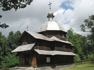
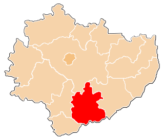
Radruż is a village in the administrative district of Gmina Horyniec-Zdrój, within Lubaczów County, Subcarpathian Voivodeship, in south-eastern Poland, close to the border with Ukraine. It lies approximately 21 kilometres (13 mi) east of Lubaczów and 101 km (63 mi) east of the regional capital Rzeszów.
Kłucko is a village in the administrative district of Gmina Radoszyce, within Końskie County, Świętokrzyskie Voivodeship, in south-central Poland. It lies approximately 9 kilometres (6 mi) south-east of Radoszyce, 20 km (12 mi) south of Końskie, and 25 km (16 mi) north-west of the regional capital Kielce.
Kwaszyn is a village in the administrative district of Gmina Działoszyce, within Pińczów County, Świętokrzyskie Voivodeship, in south-central Poland. It lies approximately 4 kilometres (2 mi) east of Działoszyce, 21 km (13 mi) south-west of Pińczów, and 60 km (37 mi) south of the regional capital Kielce.
Adamów is a village in the administrative district of Gmina Brody, within Starachowice County, Świętokrzyskie Voivodeship, in south-central Poland. It lies approximately 5 kilometres (3 mi) west of Brody, 7 km (4 mi) south-east of Starachowice, and 42 km (26 mi) north-east of the regional capital Kielce.
Radkowice-Kolonia is a village in the administrative district of Gmina Pawłów, within Starachowice County, Świętokrzyskie Voivodeship, in south-central Poland. It lies approximately 6 kilometres (4 mi) west of Pawłów, 10 km (6 mi) south of Starachowice, and 31 km (19 mi) east of the regional capital Kielce.
Maziarnia is a village in the administrative district of Gmina Bojanów, within Stalowa Wola County, Podkarpackie Voivodeship, in south-eastern Poland.
Pruszynek is a village in the administrative district of Gmina Siedlce, within Siedlce County, Masovian Voivodeship, in east-central Poland.
Koszajec is a village in the administrative district of Gmina Rybno, within Sochaczew County, Masovian Voivodeship, in east-central Poland.
Rusocin is a village in the administrative district of Gmina Dolsk, within Śrem County, Greater Poland Voivodeship, in west-central Poland. It lies approximately 7 kilometres (4 mi) north-east of Dolsk, 11 km (7 mi) south-east of Śrem, and 44 km (27 mi) south of the regional capital Poznań.
Ostrowite is a village in Gmina Lipnica, Bytów County, Pomeranian Voivodeship, in northern Poland. It lies approximately 10 kilometres (6 mi) south-west of Bytów and 55 km (34 mi) south-west of Gdańsk.
Leśna Góra is a village in the administrative district of Gmina Sulechów, within Zielona Góra County, Lubusz Voivodeship, in western Poland.

Zawada, German Zowade, is a village in the administrative district of Gmina Głogówek, within Prudnik County, Opole Voivodeship, in south-western Poland, close to the Czech border. It lies approximately 8 kilometres (5 mi) north-west of Głogówek, 20 km (12 mi) north-east of Prudnik, and 31 km (19 mi) south of the regional capital Opole.
Stawiska is a village in the administrative district of Gmina Kościerzyna, within Kościerzyna County, Pomeranian Voivodeship, in northern Poland. It lies approximately 7 kilometres (4 mi) south-east of Kościerzyna and 53 km (33 mi) south-west of the regional capital Gdańsk.
Płoki is a village in the administrative district of Gmina Choszczno, within Choszczno County, West Pomeranian Voivodeship, in north-western Poland. It lies approximately 3 kilometres (2 mi) south of Choszczno and 63 km (39 mi) south-east of the regional capital Szczecin.