
Nieuwegein is a municipality and city in the Dutch province of Utrecht. It is bordered on the north by the city of Utrecht, the provincial capital. It is separated from Vianen to the south by the river Lek and borders on IJsselstein in the southwest and Houten in the east. Nieuwegein has 64,606 inhabitants as of 1 December 2021.

The Amsterdam Metro is a rapid transit system serving Amsterdam, Netherlands, and extending to the surrounding municipalities of Diemen and Ouder-Amstel. Until 2019, it also served the municipality of Amstelveen, but this route was closed and converted into a tram line. The network is owned by the City of Amsterdam and operated by municipal public transport company Gemeente Vervoerbedrijf (GVB), which also operates trams, free ferries and local buses.

Amsterdam Zuid is a railway station situated in the borough of Amsterdam-Zuid in Amsterdam, Netherlands. For a number of years, it was named Amsterdam Zuid WTC, in reference to the neighbouring World Trade Center Amsterdam. During 2006, in conjunction with the rapid development of the area surrounding the station, the station was enlarged and the reference to the WTC was formally dropped from the name.
RandstadRail is a tram-train network in the Rotterdam–The Hague metropolitan area in the west of the Netherlands that is jointly operated by HTM Personenvervoer (HTM) and Rotterdamse Elektrische Tram (RET). It connects the cities of Rotterdam, The Hague and Zoetermeer, primarily using former train and existing tram tracks.
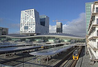
Utrecht Centraal, officially Station Utrecht Centraal, is the transit hub that integrates three bicycle parkings, two bus stations, two tram stops and the central railway station for Utrecht, Netherlands. It is the biggest train station in the Netherlands.

Tramlijn 5 is a tram line operating between Amsterdam and Amstelveen in the Netherlands. Operated by the municipal transport company GVB, the route normally runs between Van Hallstraat in Amsterdam and Stadshart in the neighbouring municipality of Amstelveen. Tram line 5 connects several important areas of the city, including the Zuidas financial district and Leidseplein, and also provides a rapid tram route south of Amsterdam Zuid station to Stadshart, Amstelveen's town centre.

The Amsterdam Tram is a tram network in Amsterdam, Netherlands. It dates back to 1875 and since 1943 has been operated by municipal public transport operator Gemeentelijk Vervoerbedrijf (GVB), which also runs the Amsterdam Metro and the city bus and ferry services. Amsterdam has the largest tram network in the Netherlands and one of the largest in Europe.
The main public transport in the Netherlands for longer distances is by train. Long-distance buses are limited to a few missing railway connections. Regional and local public transport is by bus and in some cities by metro and tram. There are also ferries.

The Utrechtse sneltram is a light rail system in the Dutch city of Utrecht. The system consists of three tram routes connecting Utrecht Centraal railway station with the residential areas of Lombok and Kanaleneiland and the suburbs Nieuwegein and IJsselstein to the southwest of the station, and with the Uithof district and Utrecht University to the southeast.

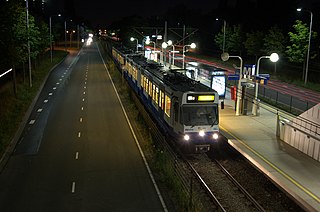
Amstelveenseweg is an Amsterdam Metro station in the south of Amsterdam, Netherlands. The station opened in 1997 and is served by line 50 and 51.
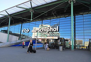
Schiphol Airport railway station is a major passenger railway station in Haarlemmermeer, Netherlands, beneath the terminal complex of Amsterdam Airport Schiphol, operated by the Nederlandse Spoorwegen. The station's six platforms are accessible via twelve escalators and three elevators located in the main concourse of the airport. The original station was opened in 1978, and the current station in 1995. It connects the airport to Amsterdam and other cities in the Netherlands, as well as to Belgium and France.

Westwijk is a tram stop serving the neighborhood of Westwijk in the city of Amstelveen, Netherlands. It serves tram line 25, dubbed the Amsteltram, which opened officially on 13 December 2020, unofficially 4 days earlier on 9 December. It used to be the southern terminus of the line until the opening of the extension to Uithoorn Centrum on 21 July 2024.
Ouderkerkerlaan is a tram stop within the city of Amstelveen, Netherlands. The stop lies along tram line 25, which was dubbed the Amsteltram before it received its line number. It opened officially on 13 December 2020, unofficially 4 days earlier on 9 December.

Sportlaan is a tram stop within the city of Amstelveen, Netherlands. The stop lies along tram line 25, which was dubbed the Amsteltram before it received its line number. It opened officially on 13 December 2020, unofficially 4 days earlier on 9 December.
Meent is a tram stop within the city of Amstelveen, Netherlands. The stop lies along tram line 25, which was dubbed the Amsteltram before it received its line number. It opened officially on 13 December 2020, unofficially 4 days earlier on 9 December.
Brink is a tram stop within the city of Amstelveen, Netherlands. The stop lies along tram line 25, which was dubbed the Amsteltram before it received its line number. It opened officially on 13 December 2020, unofficially 4 days earlier on 9 December.
Poortwachter is a tram stop within the city of Amstelveen, Netherlands. The stop lies along tram line 25, which was dubbed the Amsteltram before it received its line number. It opened officially on 13 December 2020, unofficially 4 days earlier on 9 December.

Sacharovlaan is a tram stop within the city of Amstelveen, Netherlands. The stop lies along tram line 25, which was dubbed the Amsteltram before it received its line number. It opened officially on 13 December 2020, unofficially 4 days earlier on 9 December. The tram stop serves the Legmeer business district.
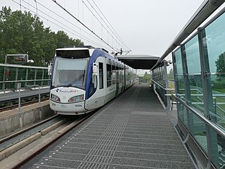
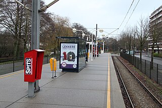
Nieuwegein-Zuid is a tram stop of the Utrecht sneltram network, located in the most southern part of Nieuwegein. The stop opened in 1983. Today it is the terminus of tram route 20 from Utrecht Central Station and P+R Science Park. It connects the Hoog-Zandveld neighbourhood of Nieuwegein with IJsselstein and Utrecht. It is located right next to a shopping center.

Amsterdam tram line 25, also known as the Amsteltram, is a tram line running south from Amsterdam Zuid station in Amsterdam via Westwijk in Amstelveen to Uithoorn Centrum in Uithoorn. It officially opened to Westwijk on 13 December 2020. The tram line replaced metro line 51, a light rail line (sneltram) that ceased running south of Amsterdam Zuid station on 3 March 2019 to convert it for low-floor trams. Tram line 5 shares the stops with line 25 between Zuid station and Oranjebaan stations. Line 5 had also shared the same tracks with metro line 51, the former using low-level platforms for regular trams, and the latter using high-level platforms.
