Nieuwveen | |
|---|---|
Town | |
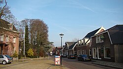 Dorpsstraat | |
 Flag  Coat of arms | |
 | |
 The town centre (dark green) and the statistical district (light green) of Nieuwveen in the municipality of Liemeer. | |
| Coordinates: 52°11′40″N4°45′25″E / 52.19444°N 4.75694°E | |
| Country | Netherlands |
| Province | South Holland |
| Municipality | Nieuwkoop |
| Population (2004) | |
• Total | 3,970 |
| Time zone | UTC+1 (CET) |
| • Summer (DST) | UTC+2 (CEST) |
Nieuwveen is a town in the Dutch province of South Holland, located close to the border of province North Holland, about 35 kilometers (22 miles) southwest of the city of Amsterdam. It is a part of the municipality of Nieuwkoop (until 2007: Liemeer), and lies about 9 kilometers (6 miles) northeast of Alphen aan den Rijn.
In 2001, the town of Nieuwveen had 2,806 inhabitants. The built-up area of the town was 0.73 km², and contained 931 residences. [1] The statistical area "Nieuwveen", which also can include the peripheral parts of the village, as well as the surrounding countryside, has a population of around 3,630 people. [2]
Zevenhoven was added to the municipality of Nieuwveen in 1991, and the municipality was renamed Liemeer in 1994. [3] The Jostiband Orchestra was founded here.