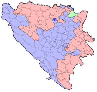
Usora is a village and municipality located in Zenica-Doboj Canton of the Federation of Bosnia and Herzegovina, an entity of Bosnia and Herzegovina. It borders with Doboj and Tešanj municipality, and it is named after the Usora River.
The Vojlovica Monastery is a Serb Orthodox monastery situated in the Banat region, in the northern Serbian province of Vojvodina. It is in the Pančevo municipality. It was founded during the time of Despot Stefan Lazarević (1374-1427).

Wola Dereźniańska is a village in the administrative district of Gmina Biłgoraj, within Biłgoraj County, Lublin Voivodeship, in eastern Poland. It lies approximately 9 kilometres (6 mi) south-west of Biłgoraj and 86 km (53 mi) south of the regional capital Lublin.
Siedliska is a village in the administrative district of Gmina Józefów, within Biłgoraj County, Lublin Voivodeship, in eastern Poland. It lies approximately 4 kilometres (2 mi) east of Józefów, 27 km (17 mi) east of Biłgoraj, and 93 km (58 mi) south-east of the regional capital Lublin.
Wysiółki is a settlement in the administrative district of Gmina Korycin, within Sokółka County, Podlaskie Voivodeship, in north-eastern Poland.

Novruzlu is a village in the Lachin Rayon of Azerbaijan.
Młynek is a village in the administrative district of Gmina Gidle, within Radomsko County, Łódź Voivodeship, in central Poland. It lies approximately 4 kilometres (2 mi) north of Gidle, 11 km (7 mi) south of Radomsko, and 90 km (56 mi) south of the regional capital Łódź.
Niesulów is a village in the administrative district of Gmina Gidle, within Radomsko County, Łódź Voivodeship, in central Poland. It lies approximately 4 kilometres (2 mi) north of Gidle, 11 km (7 mi) south of Radomsko, and 90 km (56 mi) south of the regional capital Łódź.
Strzała is a village in the administrative district of Gmina Gidle, within Radomsko County, Łódź Voivodeship, in central Poland. It lies approximately 4 kilometres (2 mi) north of Gidle, 11 km (7 mi) south of Radomsko, and 90 km (56 mi) south of the regional capital Łódź.
Chorążanka is a village in the administrative district of Gmina Tomaszów Lubelski, within Tomaszów Lubelski County, Lublin Voivodeship, in eastern Poland.
Mnichów is a village in the administrative district of Gmina Jędrzejów, within Jędrzejów County, Świętokrzyskie Voivodeship, in south-central Poland. It lies approximately 9 kilometres (6 mi) north-east of Jędrzejów and 27 km (17 mi) south-west of the regional capital Kielce.
Kamieniec is a village in the administrative district of Gmina Iwaniska, within Opatów County, Świętokrzyskie Voivodeship, in south-central Poland. It lies approximately 8 kilometres (5 mi) south-east of Iwaniska, 13 km (8 mi) south of Opatów, and 57 km (35 mi) east of the regional capital Kielce.
Wólka Lipowa is a village in the administrative district of Gmina Tarłów, within Opatów County, Świętokrzyskie Voivodeship, in south-central Poland. It lies approximately 5 kilometres (3 mi) south of Tarłów, 26 km (16 mi) north-east of Opatów, and 77 km (48 mi) east of the regional capital Kielce.
Trzylatków Mały is a village in the administrative district of Gmina Błędów, within Grójec County, Masovian Voivodeship, in east-central Poland. It lies approximately 14 kilometres (9 mi) south-west of Grójec and 50 km (31 mi) south-west of Warsaw.

Kalinowiec is a village in the administrative district of Gmina Łochów, within Węgrów County, Masovian Voivodeship, in east-central Poland. It lies approximately 11 kilometres (7 mi) south-east of Łochów, 15 km (9 mi) north-west of Węgrów, and 65 km (40 mi) north-east of Warsaw.
Dębowiec is a settlement in the administrative district of Gmina Poczesna, within Częstochowa County, Silesian Voivodeship, in southern Poland. It lies approximately 9 kilometres (6 mi) east of Poczesna, 15 km (9 mi) south-east of Częstochowa, and 53 km (33 mi) north of the regional capital Katowice.
Dęby is a village in the administrative district of Gmina Górowo Iławeckie, within Bartoszyce County, Warmian-Masurian Voivodeship, in northern Poland, close to the border with the Kaliningrad Oblast of Russia. It lies approximately 7 kilometres (4 mi) north of Górowo Iławeckie, 23 km (14 mi) north-west of Bartoszyce, and 61 km (38 mi) north of the regional capital Olsztyn.
Bēne Parish is an administrative territorial entity of the Auce Municipality, Latvia.

Tupadly is a village and municipality in Mělník District in the Central Bohemian Region of the Czech Republic.
Aru is a village in Saaremaa Parish, Saare County in western Estonia.


