
The Bodoland Territorial Region (BTR) is an autonomous division in Assam, India, and a proposed state in Northeast India. It is made up of five districts on the north bank of the Brahmaputra River below the foothills of Bhutan and Arunachal Pradesh. It is administered by an elected body known as the Bodoland Territorial Council which came into existence under the terms of a peace agreement signed in February 2003 and its autonomy was further extended by an agreement signed in January 2020. The region covers an area of over nine thousand square kilometres and is predominantly inhabited by the Bodo people and other indigenous communities of Assam.

Kamrup Rural district, or simply Kamrup district, is an administrative district in the state of Assam in India formed by dividing the old Kamrup district into two in the year 2003; other being Kamrup Metropolitan district, named after the region it constitutes. This district, along with Nalbari, Barpeta, Kamrup Metropolitan, Bajali and Baksa districts has been created from the Undivided Kamrup district.

Nagaon district is an administrative district in the Indian state of Assam. At the time of the 2011 census it was the most populous district in Assam, before Hojai district was split from it in 2016.

Nalbari is an administrative district in the state of Assam in India. The district headquarters is located at Nalbari. The district derives its name from the combination of two words, "Nal" and "Bar."

The Rabha people are a Tibeto-Burmese ethnic group who live mostly in the Northeast Indian state of Assam, with a lesser population in the adjacent state of West Bengal. They primarily inhabit the plains of Lower Assam and the Dooars, while some are found in the Garo Hills. Most of the Rabhas of Dooars refer to themselves as Rabha, but some of them often declare themselves as Kocha.

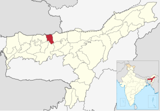
Baksa district is an administrative district in the Bodoland Territorial Region of Assam, one of the North-Eastern states of India. The administrative headquarters is at Mushalpur. Manas National Park is a part of this district.

Lower Assam division is one of the 5 administrative divisions of Assam in India. It was formed in 1874, consisting of the undivided Kamrup district of Western Assam, undivided Darrang and Nagaon districts of Central Assam and Khasi & Jaintia hills of Meghalaya, created for revenue purposes. The division is under the jurisdiction of a Commissioner, who is stationed at Guwahati. The division currently covers the Western Brahmaputa Valley. Shri Jayant Narlikar, IAS is the current Commissioner of Lower Assam division.

From the night of 1 May 2014 until the early morning hours of 3 May, a series of attacks occurred against Bengali Muslims in Assam, a north-eastern state of India. The perpetrators are suspected to be members of the terrorist group National Democratic Front of Bodoland's Songbijit faction. Speculated to be revenge for not voting for the National Democratic Front in the Lok Sabha elections, the death toll reached 32.

Chapaguri Assembly constituency is one of the 126 assembly constituencies of Assam Legislative Assembly. Chapaguri forms part of the Kokrajhar Lok Sabha constituency. It is a reserved seat for the Scheduled tribes (ST).
Tamulpur district, is an administrative district in Bodoland Territorial Region of Assam, one of the North-Eastern states of India. The administrative headquartered at Tamulpur.
Niz Juluki, also known as Nij-Juluki, is a village in Barama Tehsil of Baksa district, Assam, India. As per 2011 Census of India, Niz Juluki village has a population of 3,064 people with 80.29% literacy rate.
Nagrijuli is an urban locality and Gram Panchayat (Block) in Baksa district, Assam, India. Nagrijuli is an area with 7,426 hectares, and has a tea estate.
Athiabari is a census village in Baksa district, Assam, India. As per the 2011 Census of India, Athiabari has a total population of 4,234 people including 2,141 males and 2,093 females.
Kekerikuchi is a census village in Tamulpur district, Assam, India. As per the 2011 Census of India, Kekerikuchi has a total population of 1,867 people including 927 males and 940 females.
Dumunibagan, commonly known as Doomni and Dumuni, is a census village in Baksa district, Assam, India. The Dumni Tea Estate, tea cultivation area, is located in the village.
Darrangamela, commonly known as Darranga mela or Darangamela or Darranga, is a census village in Tamulpur district, Assam, India. As per the 2011 Census of India the village has a total population of 1,123 people including 584 males and 539 females with a literacy rate of 73.02%.
Bahbari is a census village in Tamulpur district, Assam, India. According to the 2011 Census of India, the Bahbari village has a total population of 4,214 people including 2,150 males and 2,064 females with a literacy rate of 68.58%.
Simlabari, also known as Simlubari, is a census village in Baksa district, Assam, India. As per the 2011 Census of India, the Simlabari village has a total population of 4,357 people including 2,206 males and 2,151 females with a literacy rate of 54.56%.

