
Bath is a city in the Bath and North East Somerset unitary area in the county of Somerset, England, known for and named after its Roman-built baths. At the 2021 Census, the population was 101,557. Bath is in the valley of the River Avon, 97 miles (156 km) west of London and 11 miles (18 km) southeast of Bristol. The city became a World Heritage Site in 1987, and was later added to the transnational World Heritage Site known as the "Great Spa Towns of Europe" in 2021. Bath is also the largest city and settlement in Somerset.

The Royal Crescent is a row of 30 terraced houses laid out in a sweeping crescent in the city of Bath, England. Designed by the architect John Wood, the Younger and built between 1767 and 1774, it is among the greatest examples of Georgian architecture to be found in the United Kingdom and is a Grade I listed building. Although some changes have been made to the various interiors over the years, the Georgian stone facade remains much as it was when first built.
William Wilkins was an English architect, classical scholar and archaeologist. He designed the National Gallery and University College London, and buildings for several Cambridge colleges.
John Wood, the Elder was an English architect, working mainly in Bath.

Great Pulteney Street is a grand thoroughfare that connects Bathwick on the east of the River Avon with the City of Bath, England via the Robert Adam designed Pulteney Bridge. Viewed from the city side of the bridge the road leads directly to the Holburne Museum of Art that was originally the Sydney Hotel where tea rooms, card rooms, a concert room and a ballroom were installed for the amusement of Bath's many visitors.

Park Street is a major shopping street in Bristol, England, linking the city centre to Clifton. It forms part of the A4018.
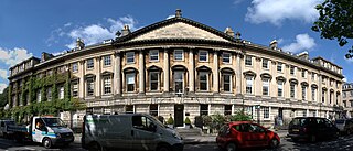
Queen Square is a square of Georgian houses in the city of Bath, England. Queen Square is the first element in "the most important architectural sequence in Bath", which includes the Circus and the Royal Crescent. All of the buildings which make up the square are Grade I listed.

Norfolk Crescent in Bath, Somerset, England was built between c.1793 and c.1822 and has been designated as a Grade II* listed building. The original design was by John Palmer, but minor alterations were later made by John Pinch.
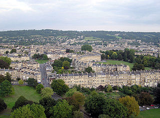
The buildings and architecture of Bath, a city in Somerset in the south west of England, reveal significant examples of the architecture of England, from the Roman Baths, to the present day. The city became a World Heritage Site in 1987, largely because of its architectural history and the way in which the city landscape draws together public and private buildings and spaces. The many examples of Palladian architecture are purposefully integrated with the urban spaces to provide "picturesque aestheticism". In 2021, the city was added to a second World Heritage Site, a group of historic spa towns across Europe known as the "Great Spas of Europe". Bath is the only entire city in Britain to achieve World Heritage status, and is a popular tourist destination.

Nelson Place West is a Grade II listed Georgian terrace of houses in Bath, Somerset, England. It was built as "Nelson Place" in the early 19th century, and the suffix "West" was added to avoid confusion with Nelson Place East on the other side of the city. The end houses have Ionic pilasters and there is a wrought iron balcony on the second floor of Nos. 2–8. These features match the adjacent Norfolk Crescent, which was built as part of the same urban development.

The Strand Campus is the founding campus of King's College London and is located on the Strand in the City of Westminster, sharing its frontage along the River Thames. The original campus comprises the Grade I listed King's Building of 1831 designed by Sir Robert Smirke, and the college chapel, redesigned in 1864 by Sir George Gilbert Scott with the subsequent purchase of much of adjacent Surrey Street since the Second World War and the 1972 Strand Building. The Macadam Building of 1975 previously housed the Strand Campus Students' Union and is named after King's alumnus Sir Ivison Macadam, first President of the National Union of Students.

Central Saint Giles is a mixed-use development in central London. Built at a cost of £450 million and completed in May 2010, it was designed by the Italian architect Renzo Piano and is his first work in the UK. The development consists of two buildings of up to 15 storeys in height, arranged around a public courtyard lined with shops and restaurants. It is chiefly notable for its façades, covered with 134,000 glazed tiles in vivid shades: orange, red, lime green and a warm yellow. It has attracted a number of high-profile tenants including NBCUniversal, MindShare, and Google.

Montpelier is an inner suburban area of Brighton, part of the English city and seaside resort of Brighton and Hove. Developed together with the adjacent Clifton Hill area in the mid-19th century, it forms a high-class, architecturally cohesive residential district with "an exceptionally complete character". Stucco-clad terraced housing and villas predominate, but two of the city's most significant Victorian churches and a landmark hospital building are also in the area, which lies immediately northwest of Brighton city centre and spreads as far as the ancient parish boundary with Hove.

The Market Hall, in Priory Street, Monmouth, Wales, is an early Victorian building by the prolific Monmouth architect George Vaughan Maddox. It was constructed in the years 1837–39 as the centrepiece of a redevelopment of part of Monmouth town centre. After being severely damaged by fire in 1963, it was partly rebuilt and is now the home of Monmouth Museum. At the rear of the building are original slaughterhouses, called The Shambles, opening onto the River Monnow. The building is Grade II listed as at 27 June 1952, and it is one of 24 buildings on the Monmouth Heritage Trail. The Shambles slaughterhouses are separately listed as Grade II*.

George Vaughan Maddox was a nineteenth-century British architect and builder, whose work was undertaken principally in the town of Monmouth, Wales, and in the wider county. Working mainly in a Neo-Classical style, his extensive output made a significant contribution to the Monmouth townscape. The architectural historian John Newman considers that Monmouth owes to Maddox "its particular architectural flavour. For two decades from the mid-1820s he put up a sequence of public buildings and private houses in the town, in a style deft, cultured, and only occasionally unresolved." The Market Hall and 1-6 Priory Street are considered his "most important projects".

Glendower Street is a historic street in the town centre of Monmouth, Monmouthshire, Wales. It extends to the southeast from the intersection of Agincourt Street and St John's Street, within the medieval town walls. Glendower Street is lined with numerous listed buildings, including one of the 24 blue plaque buildings on the Monmouth Heritage Trail.

The Nelson Rooms is a grade II listed building in Monmouth, Monmouthshire, Wales. It is in the historic Glendower Street and Agincourt Street neighbourhood, within the medieval town walls. The building initially served as a gymnasium and was a gift from Lady Llangattock to the town of Monmouth. In 1924, after the benefactor's death, it reopened as the Nelson Museum, and showcased the collection of memorabilia related to Admiral Horatio Nelson that had been amassed by the baroness. The Nelson Museum moved to new quarters at the Market Hall in 1969. The former gymnasium and museum is now an apartment building.

The following is a timeline of the history of the city of Bath, Somerset, England.

The New York Hotel is a heritage-listed former hotel located at 153-155 George Street in the inner city Sydney suburb of The Rocks in the City of Sydney local government area of New South Wales, Australia. It was built during 1908. It is now part of the modern Duty Free Store complex. The property is owned by Property NSW. It was added to the New South Wales State Heritage Register on 10 May 2002.

George Hotel is a heritage-listed former hotel at 631 George Street, Sydney, Australia. It was added to the New South Wales State Heritage Register on 2 April 1999.


