Wollumbin National Park is a national park located in northern New South Wales, Australia, 642 kilometres (399 mi) north of Sydney near the border with the state of Queensland. It surrounds Mount Warning, part of a remnant caldera of a much larger extinct volcano. The park is administered by the NSW National Parks and Wildlife Service. The park is part of the Scenic Rim Important Bird Area, identified as such by BirdLife International because of its importance in the conservation of several species of threatened birds. In addition to numerous bird species, carpet python, land mullet, eastern small-eyed snake, lace monitor, black-bellied marsh snake and long-nosed potoroo can be found here.

The Nightcap National Park is a national park situated within the Nightcap Range in the Northern Rivers region of New South Wales, Australia. The 8,080-hectare (20,000-acre) park was created in April 1983 and is situated 35 kilometres (22 mi) north of Lismore. The national park is classed by the IUCN World Commission on Protected Areas as Category II and is part of the Shield Volcano Group of the World Heritage Site Gondwana Rainforests of Australia inscribed in 1986 and added to the Australian National Heritage List in 2007.

Northern Rivers is the most north-easterly region of the Australian state of New South Wales, located between 590 and 820 kilometres north of the state capital, Sydney, and encompasses the catchments and fertile valleys of the Clarence, Richmond, and Tweed rivers. It extends from Tweed Heads in the north to the southern extent of the Clarence river catchment which lies between Grafton and Coffs Harbour, and includes the main towns of Tweed Heads, Byron Bay, Ballina, Kyogle, Lismore, Casino and Grafton. At its most northern point, the region is 102 kilometres (63 mi) south-southeast of the Queensland capital, Brisbane.

The Tweed River is a river situated in the Northern Rivers district of New South Wales, Australia. From the middle reaches of its course, the state boundary between New South Wales and Queensland is located approximately 10 kilometres (6.2 mi) north.

Nimbin is a village in the Northern Rivers area of the Australian state of New South Wales, approximately 30 km (19 mi) north of Lismore, 33 km (21 mi) northeast of Kyogle, and 70 km (43 mi) west of Byron Bay.

Tweed Heads is a town in New South Wales. It is located on the Tweed River in north-eastern New South Wales, Australia, in Tweed Shire, next to the border with Queensland and adjacent to its "twin town" of Coolangatta, which is a suburb of the Gold Coast. It is often referred to as a town where people can change time zones – even celebrate New Year twice within an hour – simply by crossing the street, due to its proximity to the Queensland border, and the fact that New South Wales observes daylight saving whereas Queensland does not.

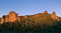
Mount Warning, a mountain in the Tweed Range in the Northern Rivers region of New South Wales, Australia, was formed from a volcanic plug of the now-gone Tweed Volcano. The mountain is located 14 kilometres (9 mi) west-south-west of Murwillumbah, near the border between New South Wales and Queensland. Lieutenant James Cook saw the mountain from the sea and named it Mount Warning.

Murwillumbah is a town in far north-eastern New South Wales, Australia, in the Tweed Shire, on the Tweed River. Sitting on the south eastern foothills of the McPherson Range in the Tweed Volcano valley, Murwillumbah is 848 km north-east of Sydney, 13 km south of the Queensland border and 132 km south of Brisbane.
The Nimbin Aquarius Festival was a counter-cultural arts and music festival organised by the Australian Union of Students. It was the fourth in a biannual series of festivals, first organised by the National Union of Australian University Students (NUAUS). The First Australian Universities Arts Festival was held in Sydney in 1967, and the Second Australian Universities Arts Festival was held in Melbourne in 1969. The third added "Aquarius" to its name and was held in Canberra in 1971. The fourth and last was held in Nimbin, New South Wales in 1973.

Tweed Volcano is a partially eroded Early Miocene shield volcano located in northeastern New South Wales, which formed when this region of Australia passed over the East Australia hotspot around 23 million years ago. Mount Warning, Lamington Plateau and the Border Ranges between New South Wales and Queensland are among the remnants of this volcano that was originally over 100 kilometres (62 mi) in diameter and nearly twice the height of Mount Warning today, at 1,156 metres (3,793 ft). Despite its size, Tweed Volcano was not a supervolcano; other shield volcanoes—such as in the Hawaiian Islands—are much larger. In the 23 million years since the volcano was active, erosion has been extensive, forming a large erosion caldera around the volcanic plug of Mount Warning. Its erosion caldera is the largest in the Southern Hemisphere.

The Needles of the Black Hills of South Dakota are a region of eroded granite pillars, towers, and spires within Custer State Park. Popular with rock climbers and tourists alike, the Needles are accessed from the Needles Highway, which is a part of Sylvan Lake Road. The Cathedral Spires and Limber Pine Natural Area, a 637-acre (258 ha) portion of the Needles containing six ridges of pillars as well as a disjunct stand of limber pine, was designated a National Natural Landmark in 1976.

Mount Price is a small stratovolcano in the Garibaldi Ranges of the Pacific Ranges in southwestern British Columbia, Canada. It has an elevation of 2,049 metres and rises above the surrounding landscape on the western side of Garibaldi Lake in New Westminster Land District. The mountain contains a number of subfeatures, including Clinker Peak on its western flank, which was the source of two thick lava flows between 15,000 and 8,000 years ago that ponded against glacial ice. These lava flows are structurally unstable, having produced large landslides as recently as the 1850s. A large provincial park surrounds Mount Price and other volcanoes in its vicinity. It lies within an ecological region that surrounds much of the Pacific Ranges.

The Scenic Rim is a group of forested mountain ranges of the Great Dividing Range, located south of Brisbane agglomeration, straddling the border between south-eastern Queensland and north-eastern New South Wales, Australia. In 2021, the Scenic Rim was named as a Lonely Planet top destination for 2022.

The Channon is a village in the Northern Rivers area of New South Wales, Australia. It is about 18 kilometres northwest of Lismore and about 21 km from Nimbin, NSW. It is part of the City of Lismore. The name of the village, Channon, comes from a local Aboriginal term for the Burrawang palm, a type of cycad that proliferates along the ridgelines in the area.

The Cascade Volcanoes are a number of volcanoes in a volcanic arc in western North America, extending from southwestern British Columbia through Washington and Oregon to Northern California, a distance of well over 700 miles (1,100 km). The arc formed due to subduction along the Cascadia subduction zone. Although taking its name from the Cascade Range, this term is a geologic grouping rather than a geographic one, and the Cascade Volcanoes extend north into the Coast Mountains, past the Fraser River which is the northward limit of the Cascade Range proper.
The Rainforest Way is a circular series of tourist drives that extends through South East Queensland, Australia across the border into the Northern Rivers region of New South Wales.
The Leycester Creek, a perennial stream of the Richmond River catchment, is located in Northern Rivers region in the state of New South Wales, Australia.

The Minyon Falls is a plunge waterfall on Repentance Creek in the Northern Rivers region of New South Wales, Australia. The waterfall descends more than 100 metres (330 ft) over the huge rhyolite cliffs which were once part of the Tweed Volcano. The water flow eroded the rocks to create the waterfall.

The Nimbin was a steel screw steamer built in 1927 at Copenhagen, that was the first motor vessel placed into the New South Wales coastal trade. It was owned and operated by the North Coast Steam Navigation Company and was the first Australian registered merchant ship to be lost during World War II when it struck a mine laid by the German auxiliary cruiser Pinguin. The Nimbin was on its way from Coffs Harbour to its home port, Sydney, with a cargo of bundled three-ply timber and a cargo of pigs. One third of the ship was blown away and it sank in three minutes. Seven men were killed. The remaining thirteen clung to bundles of plywood. Some hours later an air force plane from RAAF Base Rathmines saw the survivors and directed the coastal ship SS Bonalbo to the scene to retrieve them.

The Nightcap Range is a mountain range located in the Northern Rivers region of New South Wales, Australia, in the area between Lismore and the New South Wales-Queensland border. It includes Mount Burrell and Mount Nardi as well as containing the Nightcap National Park. The range is mainly covered with relict warm temperate rainforest and contains several rare and/or endemic species, most notably the Nightcap oak and the Minyon quandong.