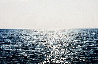
The Arabian Sea is a region of sea in the northern Indian Ocean, bounded on the west by the Arabian Peninsula, Gulf of Aden and Guardafui Channel, on the northwest by Gulf of Oman and Iran, on the north by Pakistan, on the east by India, and on the southeast by the Laccadive Sea and the Maldives, on the southwest by Somalia. Its total area is 3,862,000 km2 (1,491,000 sq mi) and its maximum depth is 4,652 meters (15,262 ft). The Gulf of Aden in the west connects the Arabian Sea to the Red Sea through the strait of Bab-el-Mandeb, and the Gulf of Oman is in the northwest, connecting it to the Persian Gulf.

The Laccadive or Cannanore Islands are one of the three island subgroups in the Union Territory of Lakshadweep, India. It is the central subgroup of the Lakshadweep, separated from the Amindivi Islands subgroup roughly by the 11th parallel north and from the atoll of Minicoy (Maliku)—far to the south—by the 9 Degree or Mamala Channel.

South Canara was a district of the Madras Presidency of British India, located at 13.00°N 75.40°E. It comprised the towns of Kassergode and Udipi and adjacent villages, with the administration at Mangalore city. South Canara was one of the most heterogeneous areas of Madras Presidency, with Tulu, Malayalam, Kannada, Konkani, Marathi, Urdu, and Beary languages being spoken side by side. It was succeeded by the Tulu-speaking areas of Dakshina Kannada district, the Malayalam-speaking area of Kasaragod district and the Amindivi islands sub-division of the Laccadives, in the year 1956.

Minicoy, locally known as Maliku, is an island in Lakshadweep, India. Along with Viringili, it is on Maliku atoll, the southernmost atoll of Lakshadweep archipelago. Administratively, it is a census town in the Indian union territory of Lakshadweep. The island is situated 425 km west of Trivandrum, the capital city of Kerala.
The Aminidivi Islands are one of the three island subgroups in the Union Territory of Lakshadweep, India. It is the northern group of the Lakshadweep, separated from the Laccadive Islands subgroup roughly by the 11th parallel north. The total land area of the group is 9.26 km².

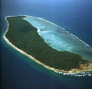
Lakshadweep is a union territory of India. It is an archipelago of 36 islands divided into three island subgroups: the Laccadive Islands in the middle with the Amindivi Islands in the north separated roughly by the 11th parallel north and the atoll of Minicoy to the south separated by the Nine Degree Channel along the 9th parallel north. The islands are sandwiched between the Arabian Sea to the west and the Laccadive Sea to the east with the islands located about 220–440 km (140–270 mi) off the Malabar Coast of mainland India.
Bitra, also known as Bitrā Par, is a coral atoll belonging to the Amindivi Subgroup of islands of the Union Territory of Lakshadweep in India. It is 483 km (300 mi) west of the city of Kochi.
Kiltan or Kilthān Island is a coral island belonging to the Amindivi Subgroup of islands of the Union Territory of Lakshadweep in India. It is at a distance of 291 km away from Kannur, 303 km away from Kozhikode, and 394 km (245 mi) west of the city of Kochi. The nearest mainland body is Cannanore and the nearest port is Mangalore.
Kalpeni is an inhabited Atoll in the Union Territory of Lakshadweep, India. It has a distance of 287 km (178 mi) west of the city of Kochi.
Chetlat Island is a coral island belonging to the Amindivi Subgroup of islands of the Lakshadweep archipelago in India. It has a distance of 432 km (268 mi) west of the city of Kochi.
The Investigator Bank is a submerged bank or sunken atoll in the Union Territory of Lakshadweep, India. It is located 31 km (19 mi) to the northeast of Minicoy Island in Lakshadweep.
Cherbaniani Reef, also known as Beleapani Reef, is a coral atoll belonging to the Amindivi Subgroup of islands of the Union Territory of Lakshadweep, India. It has a distance of 1,880 km (1,170 mi) south of the city of Delhi.
Byramgore Reef, also known as Chereapani Reef, is a coral atoll belonging to the Amindivi Subgroup of islands of the Union Territory of Lakshadweep, India. It has a distance of 1,940 km (1,210 mi) south of the city of Delhi.
Suheli Par is a coral atoll in the Union Territory of Lakshadweep, India. It is an oval-shaped 17 km long atoll surrounded by a zone of rich marine fauna.
Elikalpeni Bank is a submerged bank or sunken atoll belonging to the Amindivi Subgroup of islands of the Union Territory of Lakshadweep, India.
Pitti, also known as Pakshipitti, is an uninhabited coral islet in the Union Territory of Lakshadweep, India.
Perumal Par, also known as Peremul Par, is an uninhabited coral atoll belonging to the Amindivi Subgroup of islands of the Union Territory of Lakshadweep, India. It has a distance of 2,001 km (1,243 mi) south of the city of Delhi.

The States Reorganisation Act, 1956 was a major reform of the boundaries of India's states and territories, organising them along linguistic lines.
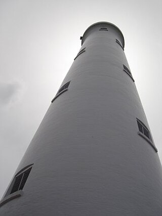
The Minicoy Island Lighthouse, which was established on 2 February 1885 at the southern end of the Minicoy Island in the Indian state of Lakshadweep during the British regime, is 49.5 metres (162 ft) in height and has now a range of 40 nautical miles (74 km) it is built in brick masonry and has a lantern and gallery.
