
Dingelstädt is a town in the district of Eichsfeld in Thuringia, Germany. It is situated on the upper course of the river Unstrut, 8 km (5 mi) south of Leinefelde-Worbis and 15 km (9 mi) northwest of Mühlhausen. The former municipalities Helmsdorf, Kefferhausen, Kreuzebra and Silberhausen were merged into Dingelstädt in January 2019.

Niederorschel is a municipality in the district of Eichsfeld in Thuringia, Germany. The former municipalities Deuna, Gerterode, Hausen and Kleinbartloff were merged into Niederorschel in January 2019. It further includes the localities of Niederorschel, Oberorschel, and Rüdigershagen.
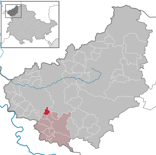
Dieterode is a municipality in the district Eichsfeld, Thuringia, Germany. It is part of the municipal association Ershausen/Geismar.

Rudolstadt is a town in the German federal state Thuringia, with the Thuringian Forest to the southwest, and to Jena and Weimar to the north.

Schleiz is a town in the district of Saale-Orla-Kreis in Thuringia, Germany. The former municipality Crispendorf was merged into Schleiz in January 2019, and Burgk in December 2019.
Bleicherode is a town in the district of Nordhausen, in Thuringia, Germany. It is situated on the river Wipper, 17 km southwest of Nordhausen. On 1 December 2007, the former municipality Obergebra was incorporated by Bleicherode. The former municipalities Etzelsrode, Friedrichsthal, Kleinbodungen, Kraja, Hainrode, Nohra, Wipperdorf and Wolkramshausen were merged into Bleicherode in January 2019. Every Thursday, there is a market held in the town.

Eisfeld is a town and a municipality in the district of Hildburghausen, in Thuringia, Germany. It is situated on the river Werra, 12 km east of Hildburghausen, and 19 km north of Coburg. The former municipality Sachsenbrunn was merged into Eisfeld in January 2019.

Hirschberg is a town in the Saale-Orla-Kreis district, in Thuringia, Germany. It is situated on the river Saale, 20 km south of Schleiz, 12 km northwest of Hof (Bavaria), and 25 km southwest of Plauen (Saxony).

Königsee is a town and a municipality in the district of Saalfeld-Rudolstadt, in Thuringia, Germany. It is situated 12 kilometres (7.5 mi) east of Ilmenau, and 35 kilometres (22 mi) south of Erfurt. The present municipality was formed on 31 December 2012 by the merger of the former municipalities Königsee and Rottenbach, under the name Königsee-Rottenbach. On 1 January 2019 the former municipalities Dröbischau and Oberhain were absorbed, and the name was changed to Königsee.

Neuhaus am Rennweg is a town in the district of Sonneberg, in Thuringia, Germany. It is situated in the Thuringian Forest, 17 km north of Sonneberg, and 22 km southwest of Saalfeld. The former municipalities Lichte and Piesau were merged into Neuhaus am Rennweg in January 2019.

Wasungen is a town in the Schmalkalden-Meiningen district, in Thuringia, Germany. It is situated on the river Werra, 11 km north of Meiningen. The former municipalities Hümpfershausen, Metzels, Oepfershausen, Unterkatz and Wahns were merged into Wasungen in January 2019.

Dermbach is a municipality in the Wartburgkreis district of Thuringia, Germany. The former municipalities Brunnhartshausen, Diedorf, Neidhartshausen, Stadtlengsfeld, Urnshausen and Zella/Rhön were merged into Dermbach in January 2019.

Weinbergen is a former municipality in the Unstrut-Hainich-Kreis district of Thuringia, Germany. It was created on 30 June 1994 in the course of a territorial reform by the merger of the municipalities of Bollstedt, Grabe, Höngeda and Seebach. On 1 January 2019, Weinbergen was dissolved, and the four villages which it consisted of were incorporated into the territory of the town of Mühlhausen. The Seebach State Bird Protection Station, located in the former municipality, is known beyond the region.

Albersdorf is a municipality in the Saale-Holzland district of Thuringia, Germany. As of 2018, the population is 288.
Weißbach is a municipality in the district Saale-Holzland, in Thuringia, Germany. The name of the location was vouched first about 1400, according to other sources in 1072. Meat production is dominating in local business.
Grabfeld is a municipality in the district Schmalkalden-Meiningen, in Thuringia, Germany.

Föritztal is a municipality in the Sonneberg district of Thuringia, Germany. It was formed on 6 July 2018 by the merger of the former municipalities Föritz, Judenbach and Neuhaus-Schierschnitz. It takes its name from the small river Föritz, a tributary of the Steinach.

Rosenthal am Rennsteig is a municipality in the district Saale-Orla-Kreis, in Thuringia, Germany. It was created with effect from 1 January 2019 by the merger of the former municipalities of Birkenhügel, Blankenberg, Blankenstein, Harra, Neundorf bei Lobenstein, Pottiga and Schlegel.

Am Ettersberg is a municipality in the district Weimarer Land, in Thuringia, Germany. It was created with effect from 1 January 2019 by the merger of the former municipalities of Berlstedt, Buttelstedt, Großobringen, Heichelheim, Kleinobringen, Krautheim, Ramsla, Sachsenhausen, Schwerstedt, Vippachedelhausen and Wohlsborn. The name refers to the hill Ettersberg.

Grammetal is a municipality in the Weimarer Land district, in Thuringia, Germany. It was created with effect from 31 December 2019 by the merger of the former municipalities of Bechstedtstraß, Daasdorf am Berge, Hopfgarten, Isseroda, Mönchenholzhausen, Niederzimmern, Nohra, Ottstedt am Berge and Troistedt, that had previously coöperated in the Verwaltungsgemeinschaft Grammetal. It takes its name from the river Gramme, that flows through the municipality.


