
The Keweenaw Peninsula is the northernmost part of Michigan's Upper Peninsula. It projects into Lake Superior and was the site of the first copper boom in the United States, leading to its moniker of "Copper Country." As of the 2000 census, its population was roughly 43,200. Its major industries are now logging and tourism, as well as jobs related to Michigan Technological University and Finlandia University.
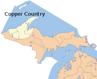
The Copper Country is an area in the Upper Peninsula of Michigan in the United States, including Keweenaw County, Michigan, Houghton, Baraga and Ontonagon counties as well as part of Marquette County. The area is so named as copper mining was prevalent there from 1845 until the late 1960s, with one mine continuing through 1995. In its heyday in the latter half of the 19th century and the early 20th century, the area was the world's greatest producer of copper.

Dee Stadium, also called The Dee, is an ice hockey arena in Houghton, Michigan, that replaced, and is located on the same site as, the Amphidrome. It is regarded as the birthplace of professional hockey, and is the seventh oldest indoor ice rink in the world.
The Minesota Mine is a former copper mine near Rockland, Ontonagon County in the Upper Peninsula of the U.S. state of Michigan. The Minesota was one of the most productive and famous early mines in the Michigan Copper Country.

The Quincy Mine is an extensive set of copper mines located near Hancock, Michigan. The mine was owned by the Quincy Mining Company and operated between 1846 and 1945, although some activities continued through the 1970s. The Quincy Mine was known as "Old Reliable," as the Quincy Mine Company paid a dividend to investors every year from 1868 through 1920. The Quincy Mining Company Historic District is a United States National Historic Landmark District; other Quincy Mine properties nearby, including the Quincy Mining Company Stamp Mills, the Quincy Dredge Number Two, and the Quincy Smelter are also historically significant.
Keweenaw National Historical Park is a unit of the U.S. National Park Service. Established in 1992, the park celebrates the life and history of the Keweenaw Peninsula in the Upper Peninsula of the U.S. state of Michigan. As of 2009, it is a partly privatized park made up of two primary units, the Calumet Unit and the Quincy Unit, and 21 cooperating "Heritage Sites" located on federal, state, and privately owned land in and around the Keweenaw Peninsula. The National Park Service owns approximately 1,700 acres (690 ha) in the Calumet and Quincy Units. Units are located in Baraga, Houghton, Keweenaw, and Ontonagon counties.
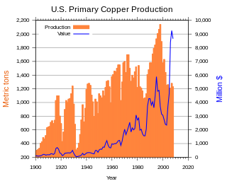
Copper mining in the United States has been a major industry since the rise of the northern Michigan copper district in the 1840s. In 2017 the United States produced 1.27 million metric tonnes of copper, worth $8 billion, making it the world's fourth largest copper producer, after Chile, China, and Peru. Copper was produced from 23 mines in the US. Top copper producing states in 2014 were Arizona, Utah, New Mexico, Nevada, and Montana. Minor production also came from Idaho, and Missouri. As of 2014, the US had 45 million tonnes of known remaining reserves of copper, the fifth largest known copper reserves in the world, after Chile, Australia, Peru, and Mexico.

The Calumet and Hecla Mining Company was a major copper-mining company based within Michigan's Copper Country. In the 19th century, the company paid out more than $72 million in shareholder dividends, more than any other mining company in the United States during that period.
The Copper Range Company was a major copper-mining company in the Copper Country of Michigan, United States. It began as the Copper Range Company in the late 19th century as a holding company specializing in shares in the copper mines south of Houghton, Michigan. The company was bought by Louisiana Land and Exploration in 1977.

Copper mining in Michigan became an important industry in the 19th and early 20th centuries. Its rise marked the start of copper mining as a major industry in the United States.

Copper mining in Arizona, a state of the United States, has been a major industry since the 19th century. In 2007 Arizona was the leading copper-producing state in the US, producing 750 thousand metric tons of copper, valued at $5.54 billion. Arizona's copper production was 60% of the total for the United States. Copper mining also produces gold and silver as byproducts. Byproduct molybdenum from copper mining makes Arizona the nation's second-largest producer of that metal. Although copper mineralization was found by the earliest Spanish explorers of Arizona, the territory was remote, and copper could seldom be profitably mined and shipped. Early Spanish, Mexican, and American prospectors searched for gold and silver, and ignored copper. It was not until the completion of the Southern Pacific Railroad in 1876 that copper became broadly economic to mine and ship to market.

The Nonesuch Shale is a Proterozoic geologic formation that outcrops in Michigan and Wisconsin, United States, but has been found by drill holes to extend in the subsurface as far southwest as Iowa.

The Cliff mine was the first successful copper mine in the Copper Country of the state of Michigan in the United States. The mine is at the now-abandoned town of Clifton in Keweenaw County. Mining began in 1845, and the Cliff was the most productive copper mine in the United States from 1845 through 1854. Large-scale mining stopped in 1878.

The Calumet Downtown Historic District is a historic district located in Calumet, Michigan, on 5th Street and 6th Street, between Scott Street and Pine Street. It is also known as the Red Jacket Downtown Historic District, reflecting the original name of the village. The Historic District is completely contained in the Calumet Historic District and the Keweenaw National Historical Park. It was designated a Michigan State Historic Site in 1973 and listed on the National Register of Historic Places in 1974.Much of the 100 block of 5th street was destroyed in a fire that took place on May 22, 2021

Winona, Michigan is an unincorporated community, ghost town and one-time boomtown of Elm River Township in Houghton County, Michigan. It was once home to over 1,000 individuals in 1920, but today is home to as few as 13. It is located 33 miles to the south of the city of Houghton off of M-26. In its heyday, Winona had restaurants, a brewery, sports teams, churches, boarding houses, a train depot, a saloon, stores, boardwalks, a school, five neighbourhoods, a dance hall and a barber shop. Only a school, a church, and a few homes remain intact.

Michigan Technological University's campus sits on 925 acres on a bluff overlooking Portage Lake.
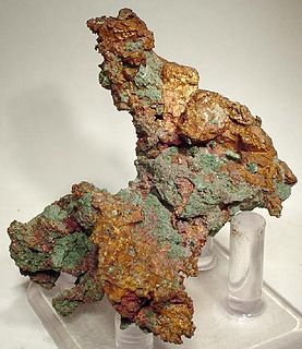
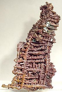
The Victoria Mine is the name given to a series of copper mines located in Rockland Township, Ontonagon County, in Michigan's Copper Country. It was near this location that a large piece of float copper, known as the Ontonagon Boulder, was found. The mine operated off and on from 1849 until its final closure in 1921. Most of the metal found there was low grade native copper from the Forest Lode. Quartz, epidote, calcite, prehnite, and pumpellyite are also found in the rock.
The Mohawk Mining Company was a major copper mining company, based in the Keweenaw Peninsula of Michigan, that was established in November 1898 and lasted until 1932. The company, between 1906 and 1932, paid out more than $15 million in shareholder dividends. The Mine is best known for the large amounts of mohawkite that were found on the property. The Mohawk mine operated until 1932; in 1934 it was purchased by the Copper Range Company.
Clarence J. Monette was a prolific author and historian from Michigan's Copper Country, writing extensively on Copper Country history. He has published more than sixty books and has written numerous outdoor survival guides.

