Aoraki / Mount Cook is the highest mountain in New Zealand. Its height, as of 2014, is listed as 3,724 metres. It sits in the Southern Alps, the mountain range that runs the length of the South Island. A popular tourist destination, it is also a favourite challenge for mountain climbers. Aoraki / Mount Cook consists of three summits: from south to north, the Low Peak, the Middle Peak and the High Peak. The summits lie slightly south and east of the main divide of the Southern Alps, with the Tasman Glacier to the east and the Hooker Glacier to the southwest. Mount Cook is ranked 10th in the world by topographic isolation.

The Southern Alps are a mountain range extending along much of the length of New Zealand's South Island, reaching its greatest elevations near the range's western side. The name "Southern Alps" generally refers to the entire range, although separate names are given to many of the smaller ranges that form part of it.

A Foehn, or Föhn, is a type of dry, relatively warm downslope wind that occurs in the lee of a mountain range. It is a rain shadow wind that results from the subsequent adiabatic warming of air that has dropped most of its moisture on windward slopes. As a consequence of the different adiabatic lapse rates of moist and dry air, the air on the leeward slopes becomes warmer than equivalent elevations on the windward slopes.

Orographic lift occurs when an air mass is forced from a low elevation to a higher elevation as it moves over rising terrain. As the air mass gains altitude it quickly cools down adiabatically, which can raise the relative humidity to 100% and create clouds and, under the right conditions, precipitation.

A rain shadow is an area of significantly reduced rainfall behind a mountainous region, on the side facing away from prevailing winds, known as its leeward side.

Chinook winds, or simply Chinooks, are two types of prevailing warm, generally westerly winds in western North America: Coastal Chinooks and interior Chinooks. The coastal Chinooks are persistent seasonal, wet, southwesterly winds blowing in from the ocean. The interior Chinooks are occasional warm, dry föhn winds blowing down the eastern sides of interior mountain ranges. The coastal Chinooks were the original term, used along the northwest coast, and the term in the interior of North America is later and derives from the coastal term.

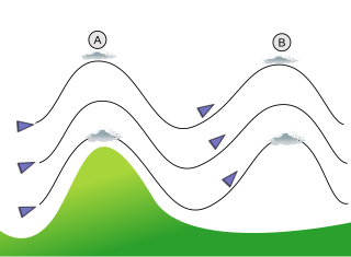
In meteorology, lee waves are atmospheric stationary waves. The most common form is mountain waves, which are atmospheric internal gravity waves. These were discovered in 1933 by two German glider pilots, Hans Deutschmann and Wolf Hirth, above the Giant Mountains. They are periodic changes of atmospheric pressure, temperature and orthometric height in a current of air caused by vertical displacement, for example orographic lift when the wind blows over a mountain or mountain range. They can also be caused by the surface wind blowing over an escarpment or plateau, or even by upper winds deflected over a thermal updraft or cloud street.

Lenticular clouds are stationary clouds that form mostly in the troposphere, typically in parallel alignment to the wind direction. They are often comparable in appearance to a lens or saucer. Nacreous clouds that form in the lower stratosphere sometimes have lenticular shapes.

Berg wind is the South African name for a katabatic wind: a hot dry wind blowing down the Great Escarpment from the high central plateau to the coast.

A Föhn cloud or Foehn cloud is any cloud associated with a Föhn (Foehn), usually an orographic cloud, a mountain wave cloud, or a lenticular cloud.

The climate of New Zealand is varied due to the country's diverse landscape. Most regions of New Zealand belong to the temperate zone with a maritime climate characterised by four distinct seasons. Winters are relatively mild and summers comparatively cool. The main contributing factors are the Pacific Ocean and latitude, although the mountain ranges can cause significant climate variations in locations barely tens of kilometres from each other. Conditions vary from extremely wet on the West Coast of the South Island to almost semi-arid in Central Otago and subtropical in Northland.

A cold front is the leading edge of a cooler mass of air at ground level that replaces a warmer mass of air and lies within a pronounced surface trough of low pressure. It often forms behind an extratropical cyclone, at the leading edge of its cold air advection pattern—known as the cyclone's dry "conveyor belt" flow. Temperature differences across the boundary can exceed 30 °C (54 °F) from one side to the other. When enough moisture is present, rain can occur along the boundary. If there is significant instability along the boundary, a narrow line of thunderstorms can form along the frontal zone. If instability is weak, a broad shield of rain can move in behind the front, and evaporative cooling of the rain can increase the temperature difference across the front. Cold fronts are stronger in the fall and spring transition seasons and are weakest during the summer.

The Canterbury–Otago tussock grasslands is an ecoregion of the South Island, New Zealand, part of the wider tussock grasslands of New Zealand.

A kalbaisakhi, also known in Assam as a bordoisila (বৰদৈচিলা) and in some English publications as a nor'wester, is a localised rainfall and thunderstorm event which occurs in Bangladesh as well as the Indian states of Bihar, Jharkhand, Odisha, Tripura, Assam, and West Bengal during summer. These storms generally occur in the afternoon or just before sunset, when thick dark black clouds start appearing over the sky and then bring gale-speed wind with torrential rain, often with hail, but spanning only a short period of time.

This glossary of meteorology is a list of terms and concepts relevant to meteorology and atmospheric science, their sub-disciplines, and related fields.

A black nor'easter is a persistent and potentially violent north-easterly storm that occurs on the east coast of Australia, particularly from southeastern Queensland to southern New South Wales, usually between late spring and early autumn, about two days a year.

The southeast Australian foehn is a westerly foehn wind and a rain shadow effect that usually occurs on the coastal plain of southern New South Wales, and as well as in southeastern Victoria and eastern Tasmania, on the leeward side of the Great Dividing Range.

The Taieri Pet is a lenticular cloud formation that occurs in the Strath-Taieri region of Otago in the South Island of New Zealand. The cloud formation is created when north-westerly winds are forced upwards over the Rock and Pillar Range.


