Nor'west arch

Last updated

The Nor'west arch, as visible from Christchurch, shows a blue belt of clear sky to the west from which high white cloud streams. Nor'west arch2.JPG
The Nor'west arch, as visible from Christchurch, shows a blue belt of clear sky to the west from which high white cloud streams.

The Nor'west arch is a weather pattern peculiar to the east coast of New Zealand's South Island. For this reason, it is also often referred to as the Canterbury arch, although it is visible in both Otago and Marlborough as well as in the Canterbury Region. It is shown in an apparent arch of high white cloud in an otherwise clear blue sky over the Southern Alps, and is accompanied by a strong hot northwesterly or northerly wind simply known as The Nor'wester.

Contents

Closer to the Canterbury coast, some distance from the mountains of the Southern Alps, it appears as a clear area of blue above the mountains, with white cloud streaming to the east from it. The phenomenon is similar to the Chinook arch seen in the Pacific regions of the United States and Canada.

Formation

The Nor'wester is a fohn wind - moist air is driven over the Southern Alps, falling as condensation on the western side, leaving the eastern plains in the rain shadow. Foehn effect mechanisms.png
The Nor'wester is a föhn wind - moist air is driven over the Southern Alps, falling as condensation on the western side, leaving the eastern plains in the rain shadow.
Typical shot of a Canterbury, New Zealand nor'west arch during sunset Northwest arch new zealand canterbury.jpg
Typical shot of a Canterbury, New Zealand nor'west arch during sunset

The Nor'west arch is a föhn cloud. The northwesterly wind drives warm moist air from over the Tasman Sea, and it is pushed up by the presence of the Southern Alps, causing it to cool rapidly. The area to the east of the divide is in the rain shadow of the Alps; much of the moisture is dumped on the West Coast, and is responsible for the temperate rainforests found there. As the air passes over the alps, the water vapour remaining becomes visible in a band of cloud over the mountains at the top of each wave of air. From the perspective of a viewer on the eastern side, this appears as an 'arch' of cloud. The standing wave or arch is caused by the moisture condensing and becoming visible towards the top of the wave and then evaporating again as the air descends to the trough of the wave.

Nor'westers caused by cold fronts will often change within a day or two to a cool southerly wind accompanied by rain showers, as the front passes through. In mid-winter, a Nor'wester is often followed by a brief but intense cold snap, frequently bringing thunder, hail, or rain and sometimes snow which may settle to sea level.

Occurrence

The Nor'west arch can be seen as far north as Amberley and as far south as Central Otago, but it is at its most prominent on the Canterbury Plains, due to the flat and low-lying nature of the land to the east of the mountains.

The Nor'wester can blow at any time of year, but is less common in winter. Many of the strongest northerly and northwesterly winds blow ahead of cold fronts. A front lying across the South Island will often extend from northwest to southeast, reaching northern parts of the West Coast before it reaches corresponding areas on the east coast. The steep air pressure gradient ahead of the cyclonic system associated with a front gives these nor'westers their strength; they will commonly reach gale force and cause isolated damage to trees and buildings. [1] Once every few years, a nor'wester will approach hurricane strength and cause widespread damage.

Effects

The heat and lack of moisture characteristic of nor'westers play a major role in the intermittent droughts experienced by Canterbury and other regions on New Zealand's eastern coasts.[ citation needed ] The Nor'wester has a deep psychological effect on many people subjected to its hot, dry nature. It has been statistically linked to increases in suicide and domestic violence. [2]

About 10 percent of people affected by the nor’wester feel elated and wonderful. But the rest feel depressed, irritable, and lacking energy. People feel they can’t cope with everyday things. ... There is irrational anxiety and a sense of foreboding.

See also

Related Research Articles

<span class="mw-page-title-main">Aoraki / Mount Cook</span> Highest mountain in New Zealand

Aoraki / Mount Cook is the highest mountain in New Zealand. Its height, as of 2014, is listed as 3,724 metres. It sits in the Southern Alps, the mountain range that runs the length of the South Island. A popular tourist destination, it is also a favourite challenge for mountain climbers. Aoraki / Mount Cook consists of three summits: from south to north, the Low Peak, the Middle Peak and the High Peak. The summits lie slightly south and east of the main divide of the Southern Alps, with the Tasman Glacier to the east and the Hooker Glacier to the southwest. Mount Cook is ranked 10th in the world by topographic isolation.

<span class="mw-page-title-main">Fog</span> Atmospheric phenomenon

Fog is a visible aerosol consisting of tiny water droplets or ice crystals suspended in the air at or near the Earth's surface. Fog can be considered a type of low-lying cloud usually resembling stratus, and is heavily influenced by nearby bodies of water, topography, and wind conditions. In turn, fog affects many human activities, such as shipping, travel, and warfare.

<span class="mw-page-title-main">Southern Alps</span> Mountain range on the South Island in New Zealand

The Southern Alps are a mountain range extending along much of the length of New Zealand's South Island, reaching its greatest elevations near the range's western side. The name "Southern Alps" generally refers to the entire range, although separate names are given to many of the smaller ranges that form part of it.

<span class="mw-page-title-main">Mistral (wind)</span> Cold northwesterly wind experienced in southern France

The mistral is a strong, cold, northwesterly wind that blows from southern France into the Gulf of Lion in the northern Mediterranean. It produces sustained winds averaging 31 miles an hour, sometimes reaching 60 miles an hour. It can last for several days. Periods of the wind exceeding 30 km/h for more than sixty-five hours have been reported. It is most common in the winter and spring, and strongest in the transition between the two seasons.

<span class="mw-page-title-main">Foehn wind</span> Type of dry down-slope wind occurring near mountains

A Foehn, or Föhn, is a type of dry, relatively warm downslope wind that occurs in the lee of a mountain range. It is a rain shadow wind that results from the subsequent adiabatic warming of air that has dropped most of its moisture on windward slopes. As a consequence of the different adiabatic lapse rates of moist and dry air, the air on the leeward slopes becomes warmer than equivalent elevations on the windward slopes.

<span class="mw-page-title-main">Orographic lift</span> Air mass forced upwards as it moves over rising terrain

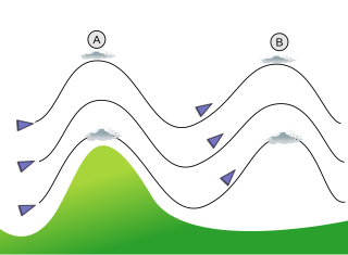
Orographic lift occurs when an air mass is forced from a low elevation to a higher elevation as it moves over rising terrain. As the air mass gains altitude it quickly cools down adiabatically, which can raise the relative humidity to 100% and create clouds and, under the right conditions, precipitation.

<span class="mw-page-title-main">Nor'easter</span> Type of cyclone occurring in the northern Atlantic coast of North America

A nor'easter is a large-scale extratropical cyclone in the western North Atlantic Ocean. The name derives from the direction of the winds that blow from the northeast. Typically, such storms originate as a low-pressure area that forms within 100 miles (160 km) of the shore between North Carolina and Massachusetts. The precipitation pattern is similar to that of other extratropical storms, although nor'easters are usually accompanied by heavy rain or snow, and can cause severe coastal flooding, coastal erosion, hurricane-force winds, or blizzard conditions. They tend to develop most often and most powerfully between the months of November and March, because of the difference in temperature between the cold polar air mass coming down from central Canada and the warm ocean waters off the upper East Coast. The susceptible regions—the upper north Atlantic coast of the United States and the Atlantic Provinces of Canada—are generally impacted by nor'easters a few times each winter.

<span class="mw-page-title-main">Rain shadow</span> Leeward side of a mountain range

A rain shadow is an area of significantly reduced rainfall behind a mountainous region, on the side facing away from prevailing winds, known as its leeward side.

<span class="mw-page-title-main">Chinook wind</span> Warm, dry wind in North America

Chinook winds, or simply Chinooks, are two types of prevailing warm, generally westerly winds in western North America: Coastal Chinooks and interior Chinooks. The coastal Chinooks are persistent seasonal, wet, southwesterly winds blowing in from the ocean. The interior Chinooks are occasional warm, dry föhn winds blowing down the eastern sides of interior mountain ranges. The coastal Chinooks were the original term, used along the northwest coast, and the term in the interior of North America is later and derives from the coastal term.

<span class="mw-page-title-main">Weather lore</span> Body of informal folklore related to the prediction of the weather

Weather lore is the body of informal folklore related to the prediction of the weather and its greater meaning.

<span class="mw-page-title-main">Weather front</span> Boundary separating two masses of air of different densities

A weather front is a boundary separating air masses for which several characteristics differ, such as air density, wind, temperature, and humidity. Disturbed and unstable weather due to these differences often arises along the boundary. For instance, cold fronts can bring bands of thunderstorms and cumulonimbus precipitation or be preceded by squall lines, while warm fronts are usually preceded by stratiform precipitation and fog. In summer, subtler humidity gradients known as dry lines can trigger severe weather. Some fronts produce no precipitation and little cloudiness, although there is invariably a wind shift.

<span class="mw-page-title-main">Berg wind</span> Wind in South Africa

Berg wind is the South African name for a katabatic wind: a hot dry wind blowing down the Great Escarpment from the high central plateau to the coast.

<span class="mw-page-title-main">Climate of New Zealand</span>

The climate of New Zealand is varied due to the country's diverse landscape. Most regions of New Zealand belong to the temperate zone with a maritime climate characterised by four distinct seasons. Winters are relatively mild and summers comparatively cool. The main contributing factors are the Pacific Ocean and latitude, although the mountain ranges can cause significant climate variations in locations barely tens of kilometres from each other. Conditions vary from extremely wet on the West Coast of the South Island to almost semi-arid in Central Otago and subtropical in Northland.

<span class="mw-page-title-main">Cold front</span> Leading edge of a cooler mass of air

A cold front is the leading edge of a cooler mass of air at ground level that replaces a warmer mass of air and lies within a pronounced surface trough of low pressure. It often forms behind an extratropical cyclone, at the leading edge of its cold air advection pattern—known as the cyclone's dry "conveyor belt" flow. Temperature differences across the boundary can exceed 30 °C (54 °F) from one side to the other. When enough moisture is present, rain can occur along the boundary. If there is significant instability along the boundary, a narrow line of thunderstorms can form along the frontal zone. If instability is weak, a broad shield of rain can move in behind the front, and evaporative cooling of the rain can increase the temperature difference across the front. Cold fronts are stronger in the fall and spring transition seasons and are weakest during the summer.

<i>Kalbaisakhi</i> Severe storms in Eastern India and Bangladesh

A kalbaisakhi, also known in Assam as a bordoisila (বৰদৈচিলা) and in some English publications as a nor'wester, is a localised rainfall and thunderstorm event which occurs in Bangladesh as well as the Indian states of Bihar, Jharkhand, Odisha, Tripura, Assam, and West Bengal during summer. These storms generally occur in the afternoon or just before sunset, when thick dark black clouds start appearing over the sky and then bring gale-speed wind with torrential rain, often with hail, but spanning only a short period of time.

<span class="mw-page-title-main">Glossary of meteorology</span> List of definitions of terms and concepts commonly used in meteorology

This glossary of meteorology is a list of terms and concepts relevant to meteorology and atmospheric science, their sub-disciplines, and related fields.

<span class="mw-page-title-main">Southeast Australian foehn</span> Weather event in Australia

The southeast Australian foehn is a westerly foehn wind and a rain shadow effect that usually occurs on the coastal plain of southern New South Wales, and as well as in southeastern Victoria and eastern Tasmania, on the leeward side of the Great Dividing Range.

<span class="mw-page-title-main">Taieri Pet</span> Cloud formation in New Zealand

The Taieri Pet is a lenticular cloud formation that occurs in the Strath-Taieri region of Otago in the South Island of New Zealand. The cloud formation is created when north-westerly winds are forced upward over the Rock and Pillar Range.

References

  1. "Dunedin homes without water as wind topples trees". Radio New Zealand . 21 December 2010. Retrieved 1 November 2011.
  2. Erick Brenstrum, Canterbury's damaging nor'wester, New Zealand Geographic. Reprinted from New Zealand Geographic No.1 (Jan-Mar 1989). Accessed 2007-06-17.
  3. Chinooks, Plains Folk, Prairie Public Broadcasting. Accessed 2007-06-17.